

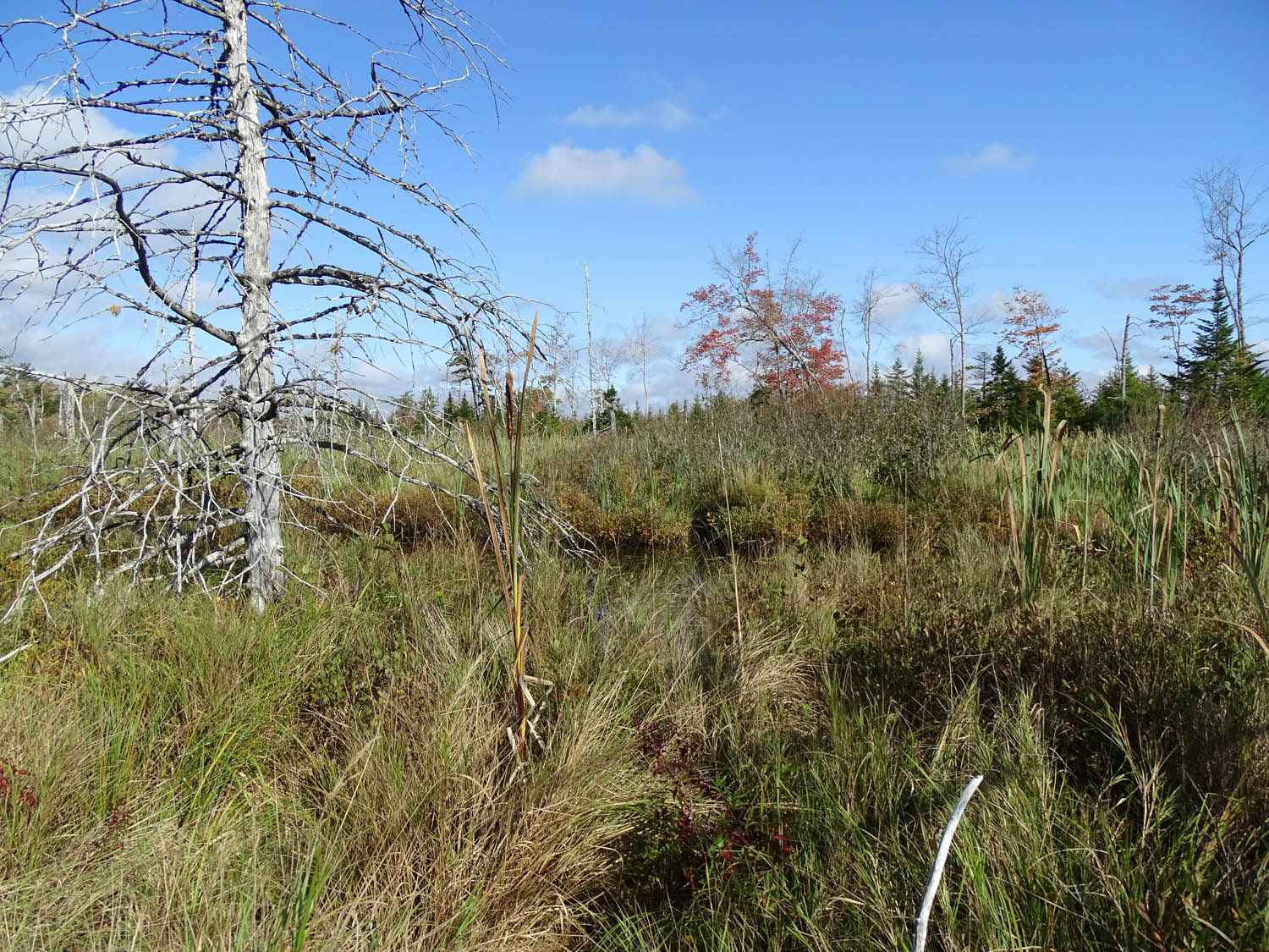
Top: View of Northern edge of a large wetland in Bedford West subarea 12; it lies on a headwater stream for Sandy Lake. Bottom: Google map of the area Click on image for larger version
Initial Comments in reference to the request for public feedback on Case 23307 – Bedford West subareas 12 & 1 Special Planning Area. I have spent some time in this area as a retired Biology Prof/naturalist looking at the landscape and wetlands, and making some measurements of salt content of the surface waters in relation to a broader assessment of the state of Sandy Lake and Environs begun in 2017 and ongoing as reported at www.versicolor.ca/sandylakebedford. My observations are made in support of the broad objectives of the Sandy Lake-Sackville River Regional Park Coalition, and of the Sandy Lake Conservation Association but are conducted and reported entirely independently of those organizations.
– David Patriquin
I submitted these comments to Dalih Salih, Senior Planner, HRM, cc to Kevin Neatt (V.P., Clayton Developments), NW Community Council, Sandy Lake Conservation Association, Sackville Rivers Association. View
Covering Letter
For Brevity, I refer to Bedford West subareas 12 & 1 as “BW12&1”
Some important features of BW12&1 and just downstream:
- BW12&1 lies entirely or close to entirely within the Sandy Lake Watershed – see Fig 2, page 3 in AECOM 2014). The Sandy Lake watershed, is the largest or 2nd largest* sub-watershed of the Sackville River Watershed *Depending on how the sub-watersheds are aggregated. View Fig 2, page 4 in the Sackville River Watershed Wetland Inventory
- Surface waters from the BW12&1 drain into Sandy Lake via the “Murphy’s Pit Convergence” and are already significantly polluted as indicated by elevated salt levels – View W and SW of S. Lake 2Oct2020 and South of HPR 20Aug2020
- BW12&1 contains significant wetlands on the watercourses that lead to Sandy Lake. View Wetlands,.. South of HPR 20Aug2020 … WESP1; also Photo Album
- The main watercourse draining BW12&1 flows partially through NIA1 wetland, aka “Walter’s Wetland” which lies north of Hammonds Plains Road and within the area proposed for new development; View Photo Album

View of NIE1 close to its center. View towards the north. Open watercourse just ahead. Vegetation predominantly sedges, grasses and cattail; and alder further back (south). Photo on Oct 2, 2020. View Location in Google Maps Under some of the development scenarios for lands west of Sandy Lake, this wetland would be eliminated.
NIA1 is a particularly impressive wetland. View this Photo Album for many photos with Google Map locations and several videos…It’s very wet – at several places I suddenly sunk up to my waist. So NIA1 stores a lot of water and a lot of water flows through it. In the AECOM Report, the area is identified as an area of maximum groundwater recharge; there is elevated land just to the west of it. Read more
Also relevant: The failure of the AECOM 2014 Phosphorus Load Model to predict effects of development on Sandy Lake WQ (water quality). It is now clear that the prediction of AECOM 2014, based on a Phosphorus Load Model (aka “Lake Capacity Model”) that major development on the west side of Sandy Lake just north of Hammonds Plains Road would be compatible with maintaining acceptable water quality in Sandy Lake is not tenable. View: DRAFT Report and Post of 21Mar2023
AECOM 2o14 recognized limitations to such predictions and advised follow-up monitoring which was not subsequently undertaken. A group of volunteers (led by myself) initiated partial monitoring in 2017 which by 2022, in combination with some historical data, illustrated a clear trend of decline in deep water oxygen, dropping to close to 1 mg/L by 2022. View Limnological Profiles and and Post of 21Mar2023
Of particular concern is the possibility that the low oxygen could trigger “internal phosphorus loading” and further accelerate eutrophication and deterioration of water quality of Sandy Lake. A completely independent set of observations conducted in 2021 by Casey Doucet in her Masters of Applied Science research confirmed the low oxygen levels, and, further, provided evidence of such internal phosphorus loading. The lake is in trouble now, even without further major development. Rising salt levels are another major concern. View Casey Doucet Thesis on Dalspace and Comments to Stantec
Also relevant: The omission of the Sandy Lake sub-watershed in floodplain modelling for the Sackville River Watershed.
In principle, the risk of flooding downstream, especially in the Bedford Mall area, from possible new development of lands by Sandy Lake should have been modelled as part of the Sackville Rivers Floodplains Study (2017). But it wasn’t.
I attended a public presentation of the Sackville Rivers Floodplains Study on Sep 22, 2018 and asked one of the consultants involved why the Sandy Lake Sub-Watershed wasn’t included in the modelling as it is the largest or 2nd largest sub-watershed in the Sackville River watershed, depending on how the watercourses are aggregated.
He said they they were following instructions from HRM, and those did not include modelling of the Sandy Lake watershed. I asked if he knew why. He said they must have assumed there would be no significant new development in the watershed over the next 100 years which was the timeframe of the modelling.
Conclusion: The impacts of development in BW12&1 and of BW12&1 in combination with proposed new development north of Hammonds Plains Road on Sandy Lake Water Quality, and on flooding downstream and if and how those might be mitigated have not been adequately assessed.
It is especially important to take into account the extreme flooding we have experienced recently, and the trend year by year of more beach closures and increasing incidents of Blue Green Algae more broadly in HRM lakes, a reflection of climate warming and increasing urbanization.
The 2022 McCallum Report recommended and Halifax Regional Council accepted the recommendation that riparian buffers in the area of the proposed expanded Sandy Lake Park, all above Hammonds Plains Road, be 50 m for wetlands and 100 m for watercourses to address critical water quality and wildlife issues.
Logically and in the same context, riparian buffers in BW12&1 should likewise be 50 m for wetlands and 100 m for watercourses. These may seem excessive in relation to past requirements in HRM but we have learned the hard way that we need to do much better to protect our natural assets and the costs of not doing so.
Postscript.
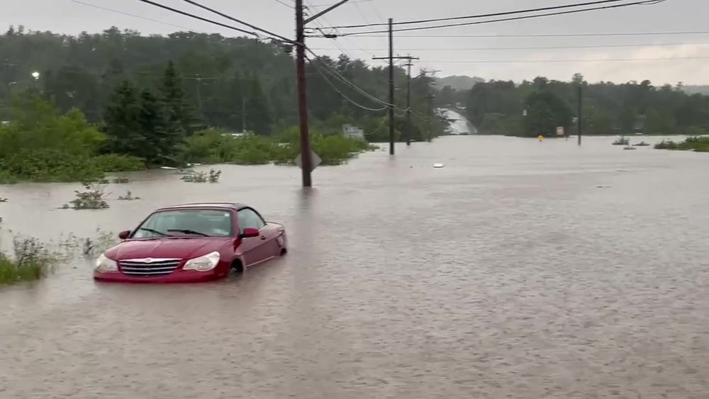
I was told about the request issued by HRM for public feedback regarding Case 23307 – Bedford West subareas 12 & 1 Special Planning Area just 2 days ago and scrambled to put together some comments for the session scheduled for tomorrow (Wed. July 26), only to discover that the session has been delayed because of all of the issues associated with recent flooding in Nova Scotia.
Of special relevance to the importance of Bedford West subareas 12 & 1 which enclose headwaters for the Sandy Lake watershed and in turn for the larger Sackville River watershed: the flooding overwhelmed a wastewater treatment plant associated with the dairy just to the west of Sandy Lake causing direct pollution to Sandy Lake (CTV 24 July); and the Bedford floodplain experienced extreme flooding (Global News July 24).
Perhaps most difficult is the realization that we can expect more of the same in the near future. Surely, that puts a premium on taking precautionary actions, whenever and wherever possible, to protect the natural assets that help to ameliorate such extreme events. In regard to BW12&1, surely that entails extra wide riparian buffers.
Also, I have viewed several developments in the Bedford-Sandy Lake-Sackville area where the developers began by clear-cutting entire areas, even when they allowed the forest to grow back over more than 50% of the area subsequently. Look at the tree cover in the google map in the top figure above and think about how their removal will affect water interception, storage and movement during future storms.
Surely going forward in mid-2023, after drought and forest fires followed by excessive precipitation and flooding all within a few months, we should (i) to improve water retention and reduce flooding issues, require that trees not be removed except where there will be hard surfaces, lawns etc.; and (ii) to reduce fire risks to properties, require that FireSmart practices be applied to all properties.
Widening riparian buffers and retaining more trees on landscapes where new developments are planned are hardly radical steps to take in 2023.
From Forest Fires to Floods
View across Sandy Lake from Sandy Lake Beach Park on May 30, 2023. From my “Photo – Diary”: This pic was taken at Sandy Lake beach Park on my way back from a hike at 4.08 pm; there were no fire clouds looking west across the lake.over the Farmers Dairy area. Roughy 1/2 hr later I drove west on Hammonds Plains Road to go to a plant nursery, also out of the fire zone. There was a big plume of smoke in the sky, I wasn’t sure exactly where it was; as I approached the road to Farmers Dairy on the west side of Sandy Lake, Fire Engines were screaming and going up that road…& a helicopter was overhead. So within approx. 1/2 hr, a fire had taken off on in forest on the west side of Sandy Lake. View News Report: Evacuations extend into Bedford after new blaze sparked in Sandy Lake West area
Bluewater Rd intersection with Hammonds Plains Rd. on July 22, 2023. Photo and related video (on facebook) by Kelly Regan. The white object is the roof of a communications cable van.