
Observations were conducted on 22 separate days over the interval June 14 to Nov 1, 2017. Two of those days were spent exclusively on Sandy Lake; the others were focused primarily on land, but some included observations on streams, wetlands and lakeshores.
Observations continued during 2018, 2019 and 2020.
The observations were exploratory and largely descriptive in nature. Several types or categories of observations were made.
Walking routes
The general locations of walking routes were chosen to provide broad coverage of the area within the proposed SLSRRP (Sandy Lake-Sackville River Regional Park).
As I walked to a desired destination or through an area I wanted to document, I took photographs and recorded observations intermittently on a low res video. Most photographs were taken with GPS-enabled cameras. On some routes or days, specific locations were also recorded as waypoints on a Garmin GPSmap 62S which is more accurate/less variable than the camera GPS units.
Routine observations included a description of the species of trees, shrubs and herbaceous plants; moss and lichen cover of soil and tree trunks; occurrence of blowdowns, snags, coarse wood debris, rocky outcrops or erratics.
I noted occurrence of all trees 20” (51 cm) and greater dbh (diameter at breast height) that were “readily visible” which were those lying within about 20-30 m on either side as I walked a particular route. In some cases I changed the route to examine an area of larger trees in the distance. I estimated and/or measured the dbh, the latter calculated from the circumference measured with a tape measure. About 1/4 of the trees were measured. Preliminary examination of those data indicate close correspondence between averages of estimated and measured values, some spread for individual trees.
Surface waters
I routinely measured electrical conductivity on watercourses that I encountered, and pH of some of them. The EC measurement were made with a pocket HM Digital Aquapro Water Tester AP-2 which measures electrical conductivity and temperature.* It was inserted directly in the water or a sample was placed in a jar and the measurement made immediately. I purchased this piece of equipment in June of 2017 specifically for this purpose (cost ~$30). It was factory calibrated with a 700 µS standard. According to the manual, readings are temperature compensated, so are Specific Conductance values (Electrical Conductivity at 25 deg C).* I had no technical issues using it and measurements on a reference sample of tap water were consistent. I purchased a second Aquapro Water Tester in July of 2020. In an in-field comparison of the two meters on Oct 2, 2020, the two meters gave identical results. A 342 ppm NaCl standard from HMDigital read 699-704 uS/cm, Temp 19.4oC (Mar 2, 2021); the ppm 500 scale valueis 684 uS/cm. (I assume the standard is HM Digital’s 700 uS/cm standard they use to factory calibrate these instruments.) View Manual for this instrument.*Available at amazon.ca (Apr13, 2026)
pH was measured with a pocket Ecosense pH10 meter on loan from the Community Based Environmental Monitoring Network (CBEMN, now the Atlantic Water Network) at St. Mary’s University. It was calibrated by SMU. The batteries tended to run put quickly so I was not able to use it consistently.
I purchased a 7Pros High Accuracy Pen Type Water Quality Tester in April of 2018. It is calibrated using buffers provided with the instrument.
Beginning on Jan 19, 2019 and using the same Aquapro Water Tester, Bruce Sarty conducted monthly measurements of electrical at several locations. He observed temperature and electrical conductivity in the field, and took the samples home and measured them again the next day.
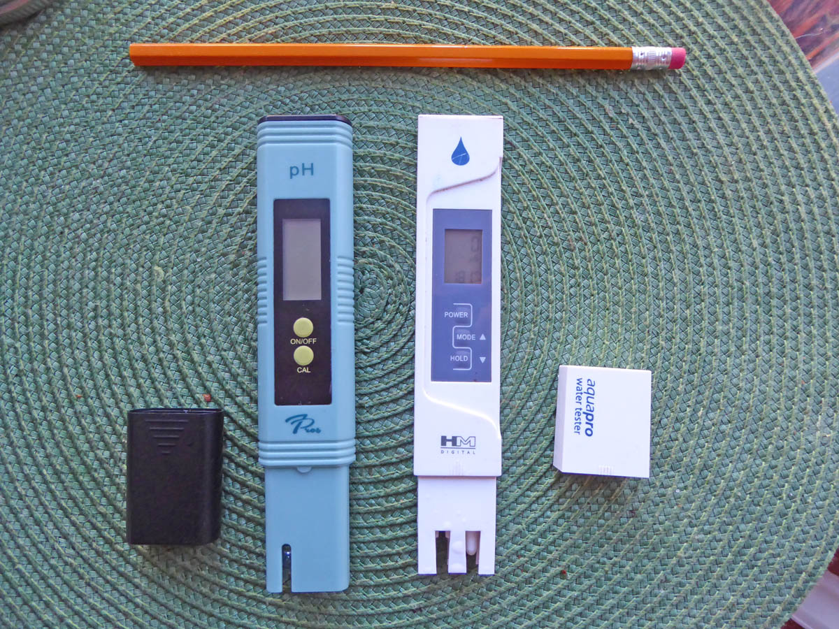
Pocket meters used for EC and pH measurements. pH meter comes with pH 4 and 6.86 calibration solutions. I use a 342 (533 uS/cm) ppm calibration solution to check the EC meter (it is factory calibrated).
A Wet-Pro Field Kit with a 30 meter probe borrowed from CBEMN was used to obtain vertical profiles of oxygen, temperature, pH and electrical conductivity at 3 sites on Sandy lake on Oct 3, 2017. A secchi disk was also borrowed from CBEMN for use on the same day. Measurements were made when there was very little wind activity.
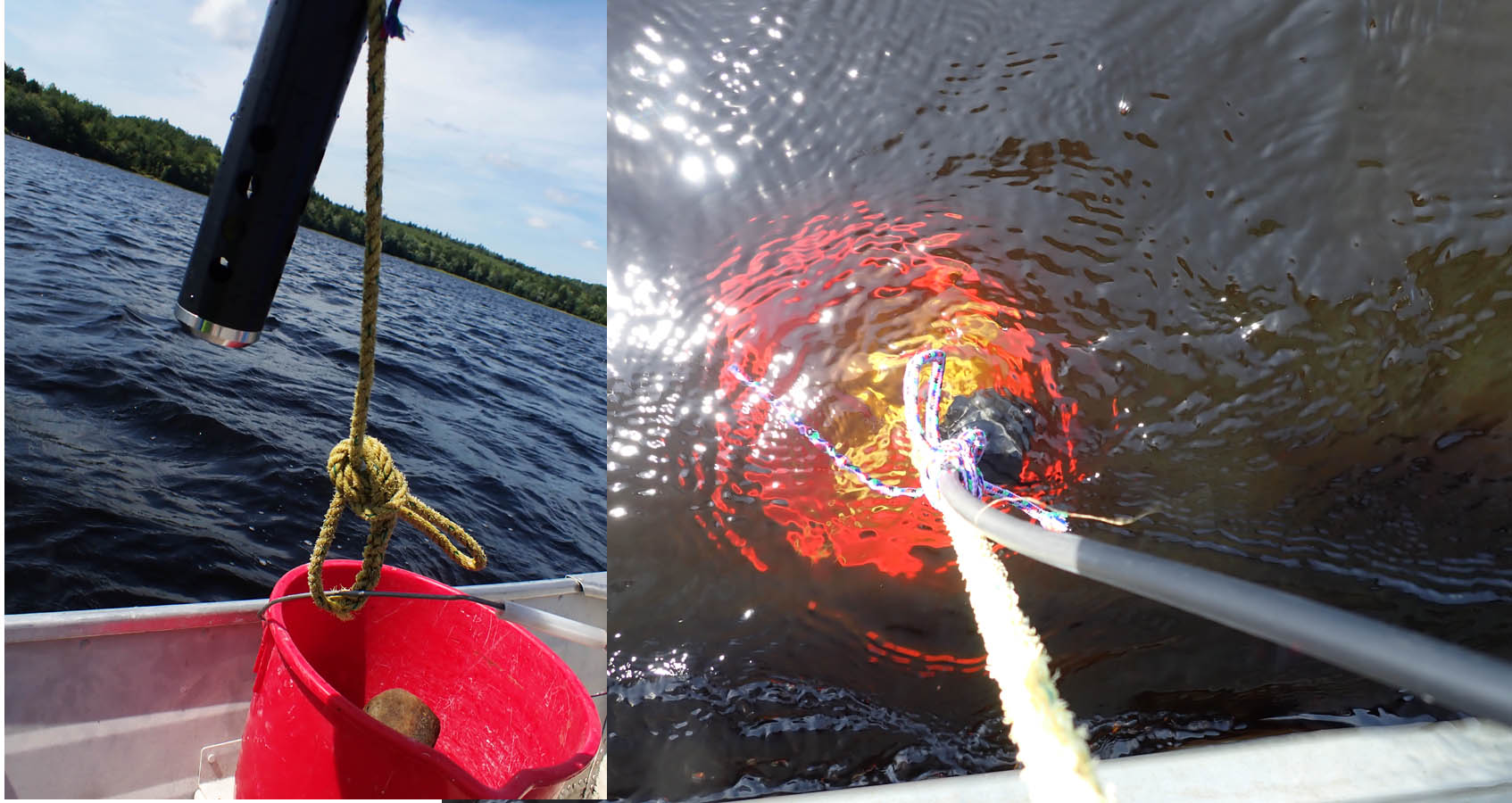 The probe was attached to a bucket full of rocks on the end of a separate line (so there was no stress on the probe cord) to ensure that is descended vertically and so that we were certain when it reached bottom. (Some instruments have a pressure sensor which provides the depth; this one did not have such a sensor. In previous work with this instrument I had found it difficult to tell when it reached the bottom, hence the bucket of rocks.) Ed Glover used the same procedure and equipment to obtain a profile at the deepest point in the lake on Sep 30, 2019.
Beginning in April of 2022, we conducted our observations under the umbrella of the newly formed HRM LakeWatchers program, which allowed us to make the observations within more consistent time intervals – prior to that, the equipment was borrowed from community equipment banks and we could not always get it at the desired sampling times.
Sandy Lake is one of 72 Lakes that had been “assessed as either highly vulnerable or moderately vulnerable through a previous study” and were selected initially to be included in the LakeWatchers Program. The Vulnerability Class for Sandy Lake was “Class A – High Vulnerability” and the Priority Concerns concerns were identified as “Eutrophication” and “Bacteria Contamination (Beaches)” – Table 9, p 53 in HRM Water Quality Monitoring Policy and Program Development (AECOM 2020)*. As Sandy lake is a “Class A — High Vulnerability Lake”. 2 sampling events per year are prescribed (Table 12, p 66)
– once in spring during mixed-water column conditions [our samplings have been in April which is at or following spring turnover of the water column]
– once at the end of summer [our sampling have been in the latter part of August which is close to the time of peak summer stratification]
Limnological profiles were/are obtained at the deepest spot in the lake; these consist of measurements made with a Water Quality Multimeter of temperature, conductivity (a measure of salt content), oxygen and (sometimes) pH at 1 meter or shorter depth intervalss.
In addition to the limnological profiles at the deepest spot in the lake, the observations at the deepest spot under the LakeWatchers program include a secchi disk measure of water transparency, top and near-bottom water samples analyzed for TP (Total Phosphorous, and chloride (near bottom sample only) . Also surface water near the outlet is sampled: measurements are made with the Multimeter as described above but there is only one surface water measurement ; and a water sample is taken and analyzed for TP ( the spring sample only) and chloride. Measurements of chlorophyll-a in water samples are sometimes made for some or all samples or none; likewise E.coli counts are sometimes made on some surface water samples.
* Halifax Regional Municipality Water Quality Monitoring Policy and Program Development, Prepared by: AECOM Canada Ltd., September 2020, 99 pages + Appendices, 505 pages total. Also view Environment & Sustainability Standing Committee June 3, 2021 SUBJECT: Water Quality Monitoring Policy & Program Development (14 pages)
Sandy Lake’s wetland fringe
On Aug 10, 2017, I paddled the margins of all of Sandy Lake, measuring or estimating the width of the fringe occupied by emergent aquatics, and noting the occurrence of floating aquatics; species were identified as possible. I made some additional observations of fringes at the northern end of the lake on several more days in August. More limited observations were made from land at Marsh Lake and Jack Lack. Measurements of electrical conductivity were made at the same times.
Old Growth
With the collaboration of Colin Gray of the Mersey Tobeatic Research Institute, three sites were assessed for Old Forest ranking according to the scheme used by the Nova Scotia Department of Natural Resources. We cored one tree at a 4th site to determine its age.
Pit and Mound Topography
Measurements were made to characterize Pit and Mound topography at the three candidate Old Growth sites. Details of methods are included with the results. This is now an ongoing study conducted with collaboration locally of Bob Guscott, a retired NSDNF forester. Bob has been conducting similar observations in the area of Grand Lake (Oakfield, NS). With soil scientist Dr. Elena Ponomarenko and ecologist Donna Crossland we are members of a “Pit and Mound Working Group”.
Drone photography
I suggested to Karen Robinson of the SLCA that it would be nice to obtain some drone photography of Sandy Lake and Environs when the leaves are changing and different species are most readily discerned. The SLCA made arrangements to obtain some drone video and photographs in the second half of October; credits are cited where I have made use of these materials.