
Some Literature and links relevant to wetlands in Nova Scotia
 The Menu on NSE Wetlands Page, Click on image to go to functional menu Nova Scotia Wetlands A few of the sections:
|
| NS Natural Resources: Nova Scotia Wet Places The NS Wet Places series introduces readers to wetland habitats found in Nova Scotia. Each factsheet highlights a habitat, describing its appearance, ecology and contribution to the environment. The series fosters an understanding and appreciation of nature, and promotes conservation. Titles in the NS Wet Places series: – Freshwater wetlands Overview doc. – Freshwater marshes A freshwater marsh is a nutrient-rich wetland that normally is covered with water throughout the year. Marshes tend to have a mix of lush aquatic plants and open water, and be bordered by shrubs and grasses. Often marshes develop on the edge of ponds and lakes or along the sides of streams and rivers. In fact, many marshes are actually old beaver ponds or shallow lakes that have become in-filled over time. There are two general classes of marsh: deep marsh and shallow marsh. Deep marshes have water depths averaging between 15 – 90 cm during summer. The most conspicuous types of plants in a deep marsh are emergents – plants that stand above the water’s surface. Floating plants and submergent (underwater) plants also occur in deep marshes. Shallow marshes average less than 15 cm in depth during summer and are usually covered with emergent plants. – Bogs and fens Bogs and fens are poorly drained areas that are covered with either sphagnum moss or grass-like sedges and are filled with decomposing plant matter or ‘peat.’ It is this overwhelming presence of peat that largely distinguishes bogs and fens from other wetlands. Generally, bogs and fens – also called ‘peatlands’ – appear quite similar. On the surface, both are mostly open areas covered with knee-high shrubs and either moss or sedges, and bordered by coniferous trees, primarily black spruce…Bogs are like bowls full of peat and water. They tend to be self-contained wetlands whose sole source of water is rainfall…Fens are connected to small streams or lakeshores and may also receive water from surrounding uplands. Unlike in bogs, water slowly moves through a fen. – Floodplains Floodplains are nutrient-rich wetlands that form on banks of rivers and streams that seasonally flood. In summer, they appear mainly as grassland meadows that sometimes are interspersed with marshy areas. Some floodplains also may contain shrubs and trees. – Swamps Swamps are similar to freshwater marshes in form and function. They develop in depressions surrounded by higher ground and can either be wet like marshes or merely waterlogged. The main distinction between marshes and swamps is water level. In Nova Scotia, marshes tend to be covered with standing water throughout most of the year whereas swamps are normally just moist on the surface. Swamps regularly form where seasonal flooding occurs, such as at the edge of ponds and lakes, and along borders of streams and rivers. Low lying areas with nearby ground seepage and springs also tend to develop into swamps. Two general types of swamp exist in Nova Scotia: shrub swamps and wooded swamps. Shrub swamps are permanently or seasonally flooded areas. Dominant plants are tall bushes like alder, and low bushy shrubs like sweet gale and rhodora. Wooded swamps usually experience flooding during spring and fall and tend not to be as wet as shrub swamps. Because the soil of a wooded swamp is not constantly waterlogged, deciduous and coniferous trees such as red maple, black spruce and balsam fir are able to establish themselves. Shrubs flourish in wetter spots within a wooded swamp. – Lakeshore wetlands Lakeshore wetlands are generally nutrient-low wetlands that develop in protected shallow margins along lake shorelines. A wide variety of plants, ranging from grass-like sedges to water lilies, grow in zones on the shoreline that are non-rocky and where wave action is minimal. Aquatic plants can grow in shallow waters where there is sufficient penetration of sunlight to a lake bottom. In essence, lakeshore wetlands are pockets of marshy habitat that occur along lakeshores. Several factors determine the kinds of plants that grow in each lakeshore wetland: water depth, nutrient level, amount of wave action and fluctuation in seasonal water levels. For example, broad-leaved plants such as pickerelweed and arrowhead flourish in calm protected areas. Thin-leaved plants like sedges and rushes are more tolerant of disturbance from wind and waves. Lakeshore wetlands often link with nearby marshes, swamps and fens, making it difficult to distinguish a border between adjoining wetlands. Consequently, lakeshore wetlands may appear as mixtures of several different types of wetland. |
Canadian Wetland Classification System, 2nd Ed
By the National Wetlands Working Group / Edited by B.G. Warner and C.D.A. Rubec. 1997. 76 pages, illustrated.
Manual for Wetland Ecosystem Services Protocol for Atlantic Canada (WESP-AC): Non-tidal Wetlands
Paul Raymond Adamus. New Brunswick Department of Environment and Local Government Fredericton, New Brunswick April 2018. “WESP-AC is a standardised method for rapidly assessing some of the important natural functions of non-tidal wetlands in Atlantic Canada. An accompanying document contains a standardised method for rapidly assessing some of the important natural functions of tidal wetlands in the same region.”
A Citizen’s Guide to Wetland Conservation in the Halifax Regional Municipality
Prepared by East Coast Environmental Law In partnership with the Ecology Action Centre with support from the Sage Environmental Program 20 February 2014
Natural Freshwater Lakes and Ponds in New Hampshire: Draft
Nichols, W. F. 2015.NH Natural Heritage Bureau. Includes descriptions of wetland vegetation in relation to lake & pond trophic status
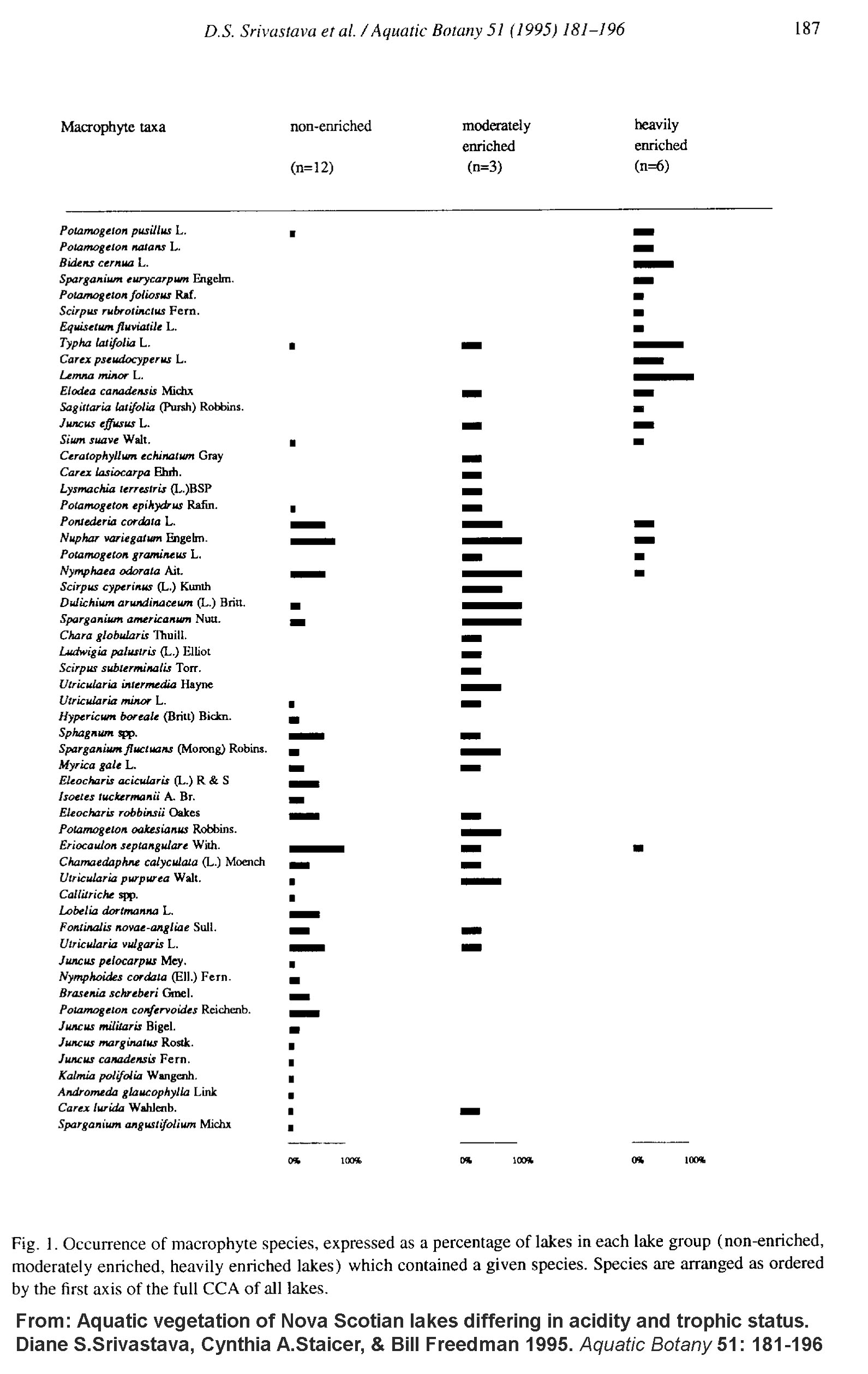
Aquatic vegetation of Nova Scotian lakes differing in acidity and trophic status
Diane S.Srivastava, Cynthia A.Staicer, & Bill Freedman 1995. Aquatic Botany 51: 181-196 “Aquatic macrophytes of the littoral zone were surveyed in 21 Nova Scotian lakes, and macrophyte composition was interpreted in relation to chemical and physical characteristics. The lake set included both nutrient-enriched and acidified lakes, and consequently had a wide range of water chemistry variables, notably pH (3.7–8.3) and total phosphorus (0.003–6.0 mg l−1). Using canonical correspondence analysis, we related differences in vegetation among lakes to 14 water chemistry and three physical variables. Alkalinity, total phosphorus, and total nitrogen were most strongly correlated with differences in vegetation between heavily enriched, moderately enriched and non-enriched lakes. Interestingly, macrophyte composition was not strongly correlated with pH. Even in a subset of lakes consisting of moderately enriched and non-enriched lakes, alkalinity, total phosphorus and total nitrogen remained strongly correlated with vegetation differences. By contrast, vegetation differences among non-enriched laks correlated most strongly with substrate slope, lake area, calcium, and alkalinity.” View Figure 1 showing species in relation to trophic status
Connectivity of Streams and Wetlands To Downstream Waters: A Review and Synthesis of the Scientific Evidence (Final Report)
U.S. Environmental Protection Agency, Washington, DC, EPA/600/R-14/475F, 2015. “The report summarizes current scientific understanding about the connectivity of streams and wetlands to downstream waters. EPA has conducted a thorough review of the literature – more than 1,200 peer-reviewed and published documents – on the scientific evidence regarding the effects that streams, nontidal wetlands, and open -waters have on larger downstream waters such as rivers, lakes, estuaries, and oceans. The focus of the report is on surface and shallow subsurface connections by which small or temporary streams, nontidal wetlands, and open waters affect larger waters such as rivers, lakes, reservoirs, and estuaries. EPA, along with other federal agencies and states, can use this scientific report to inform policy and regulatory decisions, including the Clean Water Rule being developed by EPA and the U.S. Army Corps of Engineers.”
Also published as CONNECTIVITY OF STREAMS AND WETLANDS TO DOWNSTREAM WATERS: AN INTEGRATED SYSTEMS FRAMEWORK
Scott G. Leibowitz et al., 2018. J Am Water Resour Assoc. 54(2): 298–322.
Rivers and Streams: Life in Flowing Water
By: Declan McCabe © 2011 Nature Education in Nature Education Knowledge 3(10):19 Learning Resource. “What lies beneath? Rivers: diverse habitats with broadly varying niches. Communities reflect and influence local, upstream, downstream, and broader landscape conditions.”
AQUATIC PLANTS – Lake Stewards of Maine
basic Info on aquatic plants, seasonal wetland plant communities, aquatic invasives, key to common species of aquatic plants, links.
Nova Scotia Wetland Plant Indicator List
Nova Scotia Environment “The Nova Scotia Wetland Indicator Plant List was developed by Sean Blaney at the Atlantic Canada Conservation Data Centre in 2011. It is primarily intended to assist professional wetland assessors identify wetland habitats and their boundaries based on the plants that are present, but will also be useful to anyone with an interest in wetland habitats and the plants that characterize them. In addition to a plant’s wetland indicator rating, phytogeographic (e.g., northern, temperate deciduous, or coastal plain flora affinities) and additional habitat affinities are included for many species, as are rarity ranks and status as exotic or native species. Details are included in the Data Dictionary, but habitat affinities in addition to affinity for wetlands include (e.g., floodplain, shoreline, marsh, swamp, peatland, forest, seep and aquatic habitat affinities) and physical-chemical tolerances (e.g., pH, salinity).”
Recovery Strategy and Management Plan for Multiple Species of Atlantic Coastal Plain Flora in Canada
Environment Canada and Parks Canada Agency. 2010 96 pp. + appendices.
Ontario Wetland Evaluation System, 3rd edition
(version 3.2)
Ontario Ministry of Natural Resources. Comprehensive
AQUATIC PLANTS – Lake Stewards of Maine
basic Info on aquatic plants, seasonal wetland plant communities, aquatic invasives, key to common species of aquatic plants, links.
Nova Scotia Wetland Plant Indicator List
Nova Scotia Environment “The Nova Scotia Wetland Indicator Plant List was developed by Sean Blaney at the Atlantic Canada Conservation Data Centre in 2011. It is primarily intended to assist professional wetland assessors identify wetland habitats and their boundaries based on the plants that are present, but will also be useful to anyone with an interest in wetland habitats and the plants that characterize them. In addition to a plant’s wetland indicator rating, phytogeographic (e.g., northern, temperate deciduous, or coastal plain flora affinities) and additional habitat affinities are included for many species, as are rarity ranks and status as exotic or native species. Details are included in the Data Dictionary, but habitat affinities in addition to affinity for wetlands include (e.g., floodplain, shoreline, marsh, swamp, peatland, forest, seep and aquatic habitat affinities) and physical-chemical tolerances (e.g., pH, salinity).”
Ontario Wetland Evaluation System, 3rd edition
(version 3.2)
Ontario Ministry of Natural Resources. Comprehensive