
An Estimate of water input to Sandy Lake from settled versus unsettled areas
An estimate of the proportion of water going into Sandy Lake that comes from settled areas, versus water coming from intact landscapes can be made from the EC (salt) values for lake water, water coming from settled areas, and water coming from intact landscapes.
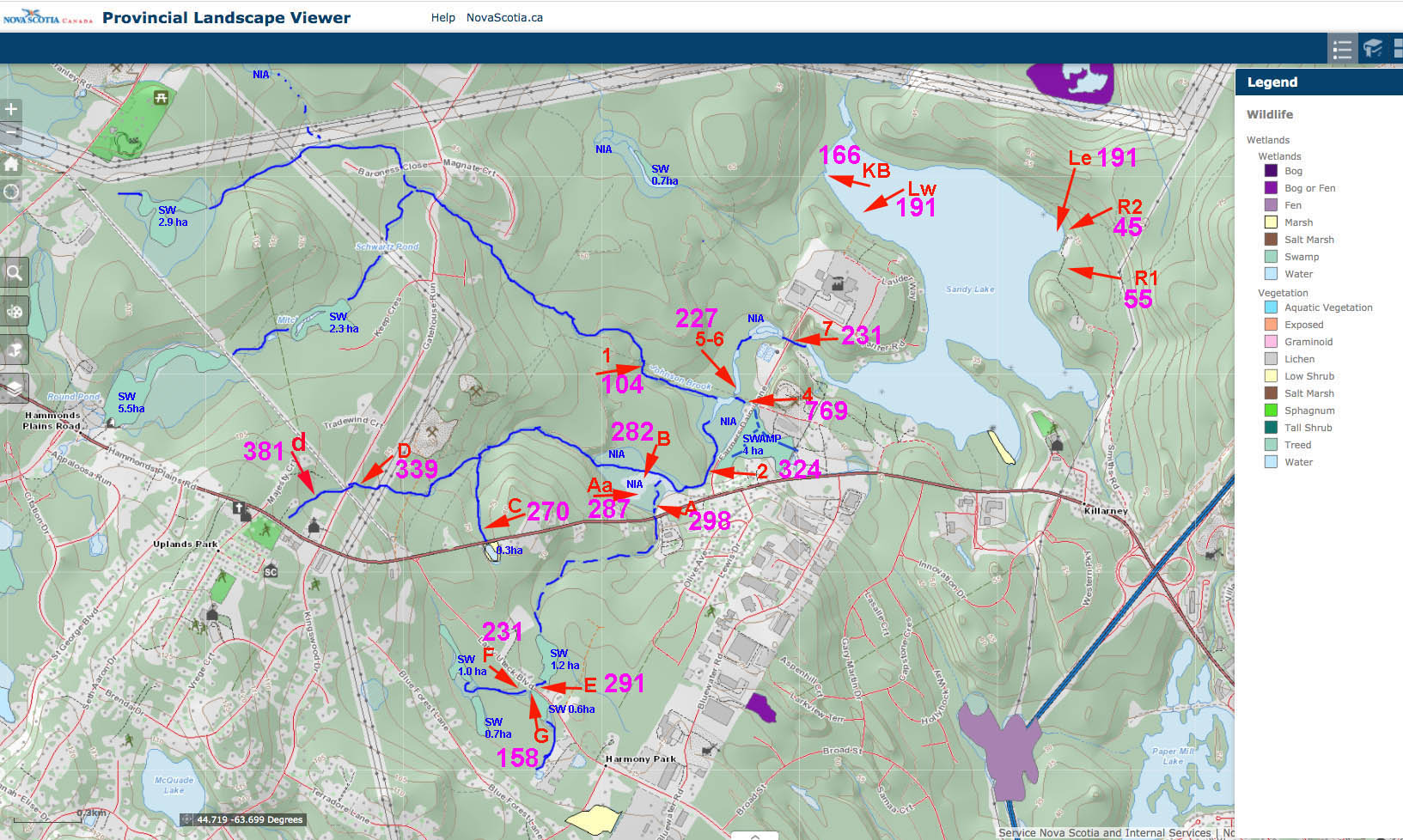
EC Values Oct 2, 2020
Click on image for larger version
For Oct 2, 2020, the value at the inlet at the southwest corner of the lake – water from partially settled landscape – was 231 uS/cm. The lake water was 191 uS/cm, and two streams on the east side (undeveloped landscape) averaged 50 uS/cm.
So we can ask: If we were going to mix water from settled areas (231 uS/cm) with water from intact landscapes (50 uS/cm) what proportion of each would we need to get a mixture with an EC value of 191 uS/cm (the lake water)?
The Answer: 0.78 parts of water (or 78%) from settled areas and 0.22 parts of water (or 22%) from intact landscapes:
(0.78*231) + (0.22*50) = 191
The average value for water samples taken at the inlet at the SW corner 11 times over the course of 2019 is 232 uS/cm, i.e., similar to the above. Other values for surface waters on the east side of the lake are in the range 30 to 55 uS/cm (n=6), so are also of similar magnitude to the value used above.
This is a very simplified “mass balance” calculation, but it gives an idea of the relative magnitude of the two sources. Some water enters as ground water rather than surface water; AECOM 2014 estimated it as 11% of total flow into the lake.
So here is what I think can be concluded:
Two-thirds or more and possibly as much as 80% of the water entering Sandy Lake in 2020 is significantly influenced by built landscape to the west and southwest of Sandy Lake, even though much of that area is still not developed.
This conclusion is consistent with comments in AECOM 2014, Appendix A – Page 6 :
The greatest flow into Sandy Lake is from Bobs Brook and other tributaries from the western portion of the watershed. Bobs Brook and its tributaries accumulate flow from Lucasville, Uplands Park, Kingswood North and Atlantic Acres Industrial Park.
Comment May 14, 2026: Not identified as a significant tributary by AECOM… (to be added)
Page created/calculations on Nov 22, 2020