
 View subsections
Also view (this website under Geology): Groundwater
“Surface water is any body of water above ground, including streams, rivers, lakes, wetlands, reservoirs, and creeks. The ocean, despite being saltwater, is also considered surface water. Surface water participates in the hydrologic cycle, or water cycle, which involves the movement of water to and from the Earth’s surface. Precipitation and water runoff feed bodies of surface water. Evaporation and seepage of water into the ground, on the other hand, cause water bodies to lose water.
“Water that seeps deep into the ground is called groundwater.
“Surface water and groundwater are reservoirs that can feed into each other. While surface water can seep underground to become groundwater, groundwater can resurface on land to replenish surface water. Springs are formed in these locations.” – National Geographic
Useful Links on Surface Water & Groundwater
- What is surface water and what affects its availability?
Webpage of American Geoscience Institute- NS Environment: Surface Water
- NS Environment: groundwater
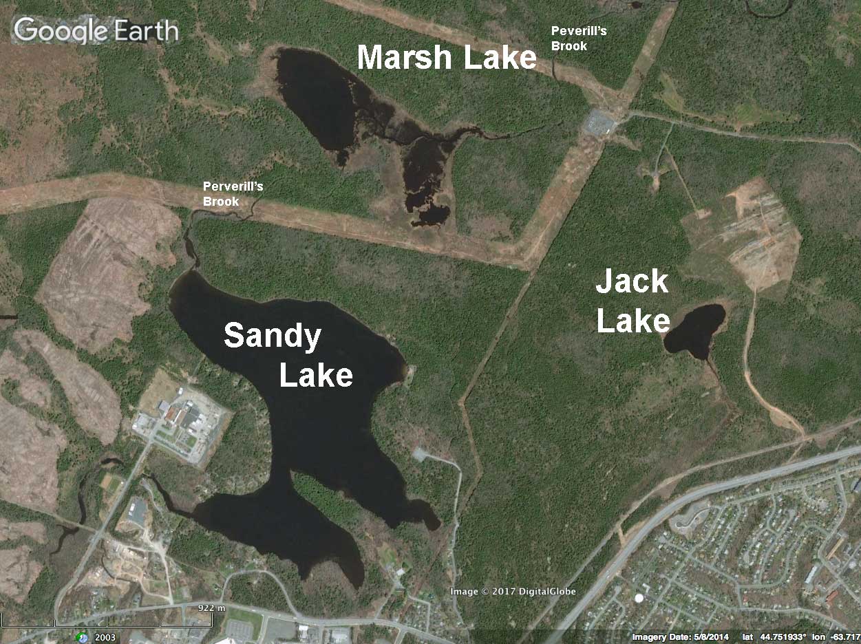
The three lakes of Sandy Lake & Environs shown on Google Earth. Sandy Lake flows into Marsh Lake and thence into the Sackville River. Jack lake is in a separate watershed. Sandy Lake, but not Marsh Lake and Jack Lake receives waters from storm sewers.
Click on images on this page for larger versions
THE THREE LAKES
There are three lakes in the area encompassed by Sandy Lake and Environs/ the proposed Sandy Lake-Sackville River Regional Park:
Sandy Lake, a headwater lake in the Sackville River watershed; 74 ha area, 21.7 m max depth; hosts Atlantic salmon.
Marsh Lake, downstream from Sandy Lake via Peverill’s Brook; 22 ha, max depth 2.2 m, it drains into the Sackville River.
Jack Lake, on a separate watershed, 2.8 ha, 7 m max depth; very acidic, boreal in nature; drains into Papermill Lake (outside of the proposed Sandy Lake Regional Park) and thence to the Bedford Basin.
Some morphometric and water chemistry data for the three lakes from the Jack Lake CHMC/NSDH Report (1986) are given below:
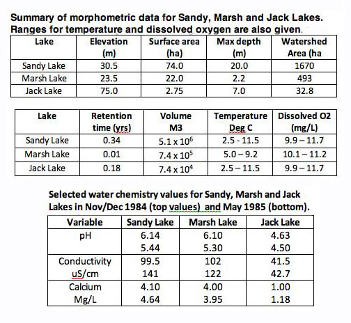
Morphometric (above) and chemical (below) stats for the three lakes. From Jack Lake Environmental Evaluation Final Report. Canada Mortgage and Housing Corporation & Nova Scotia Department of Housing, 1986.
So these are quite different lakes. Sandy Lake is relatively deep, Marsh Lake shallow, and Jack Lake very small and acidic. Sandy Lake and Jack Lake are deep enough to stratify (according to Brylinski, 2002, such lakes are larger than 1 ha and generally >3 m depth for brown-water lakes and >6 m for clear-water lakes). Jack Lake is a brown water lake, Sandy Lake has very little colour, Marsh Lake, some. Sandy Lake, but not Marsh Lake and Jack Lake receives waters from storm sewers.
Maps
SW Fig 1. Topographic Map showing Lakes, Streams & Wetlands of Sandy Lake & Environs.
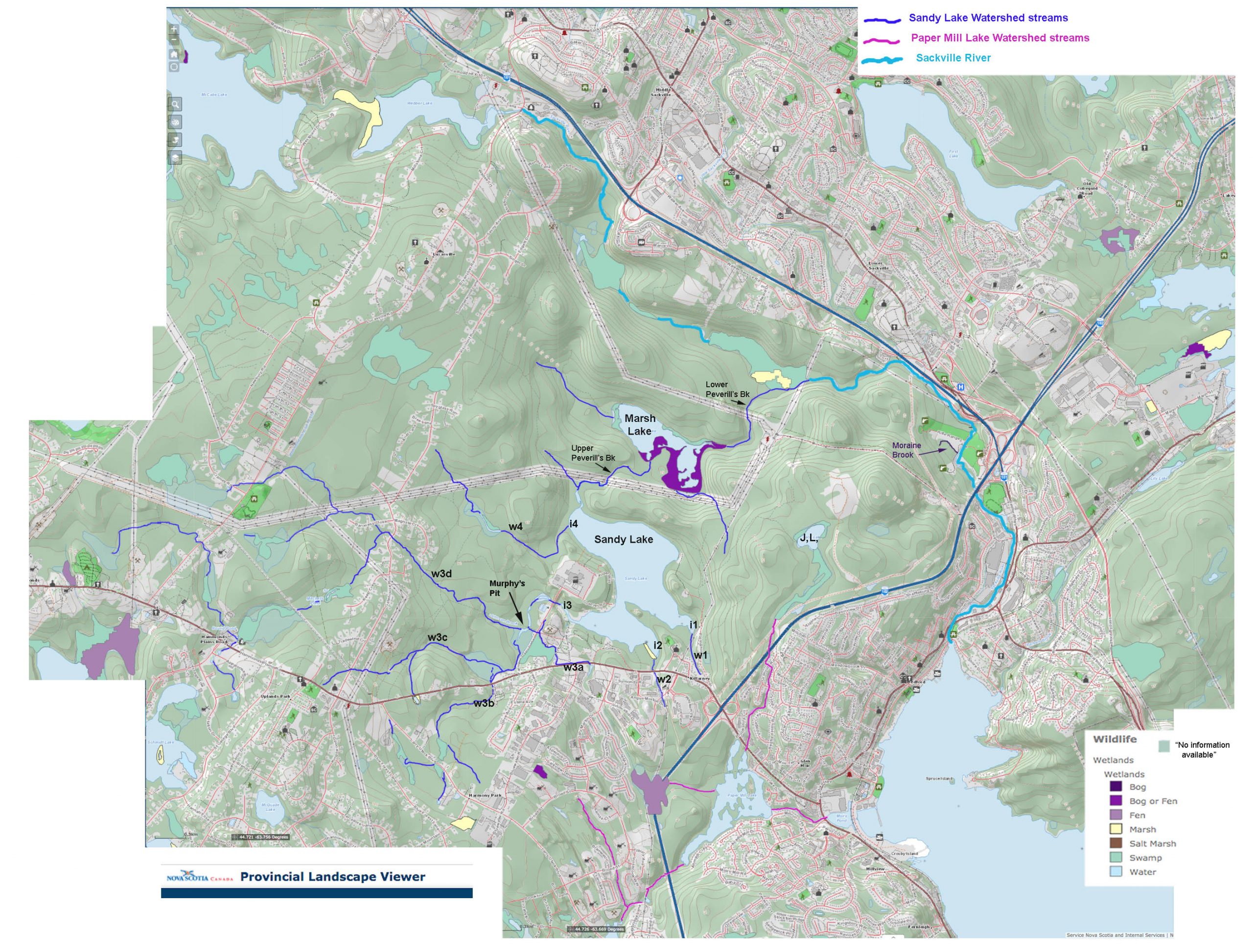
From the NS Provincial Landscape Viewer 8Jan2021. Click on image for larger version. Streams within the Sandy Lake watershed and in other watersheds within the proposed Sandy Lake-Sackville River Regional Park are highlighted. i1-i4: Major inlets on Sandy Lake. w1-w4: Major watercourses associated with each of the 4 inlets. Wetlands: view key at bottom right. Note: some areas or patches within watercourses are labelled “No Information Available“, so their status as “wetlands” is not clear from the PLV. They could, for example, be floodplain forest, which is not classified as wetland, or they might be swamp or marsh. Smaller streams are not identified in the PLV. Lakes: Sandy Lake flows into Marsh Lake and thence to the Sackville River. Jack Lake (JL in map above) flows into Papermill Lake and thence into Bedford Basin.
| The term “watercourse” is used here in a broad sense to include “the bed and shore of a river, stream, lake, creek, pond, marsh, estuary or salt-water body that contains water for at least part of each year” (from NS Wildlife Habitat and Watercourses Protection Regulations). “Stream” is used in a more restricted sense as “A body of running water moving under the influence of gravity to lower levels in a narrow, clearly defined natural channel” (medwet.org). The watercourses highlighted above are those which have a direct influence on water flow and water quality of any of the three lakes and/or on the Sackville River, i.e. those through which water flows into any of the three lakes and/or the Sackville River; they are characterized by distinct streams (some are seasonal), and many or most include wetlands (swamp, marsh, fen); some may include floodplain forest. The NS Guide to Altering Watercourses (2015) provides some relevant diagrams, definitions, also for the Riparian Zone. View this Lit&Links page for description of wetland types. |
Fig SW2 Google Earth Maps with overlays showing (a) watershed boundaries and area of acid slate within the Sandy Lake sub-watershed; (b) existing and proposed parkland/protected area (the proposed Sandy Lake-Sackville River Regional Park).
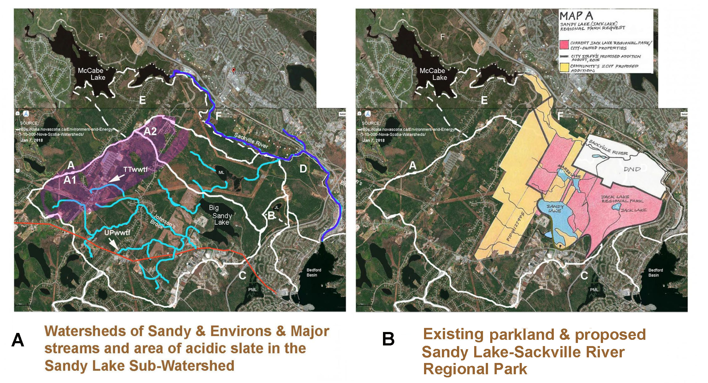
Fig A: Watersheds are A Sandy Lake Sub-watershed, E South McCabe Lake Subwatershed, F North McCabe Lake Subwatershed all in the Sackville River Watershed; and B Jack Lake Sub-watershed of C Papermill Lake Watershed. Purple shading is area bedrock with acid-generating potential within the Sandy Lake Sub-watershed. Turquoise highlighted streams are major streams within the Sandy lake Sub-watershed, dark blue is Sackville River. Fig B Coloured area encompasses the proposed Sandy Lake-Sackville River Regional Park; current HRM-owned properties are pink. DND= Canada Department of Defence.
From AECOM 2014, 3. Hydrology
The Sandy Lake watershed extends over 24.2 km2 and includes all flow from the catchment area upstream of where Peverills Brook flows into the Sackville River. The primary surface water features in the Sandy Lake watershed are Sandy Lake, Marsh Lake, Peverills Brook and Bobs Brook, also called Johnsons Brook (Figure 1). The topography
of the Sandy Lake watershed consists of an upland area in the northwest, a depression containing Sandy Lake and Marsh Lake, and a slight rise in topography to the east. The highest elevation in the watershed is 139 meters above sea level.
The greatest flow into Sandy Lake is from Bobs Brook and other tributaries from the western portion of the watershed. Bobs Brook and its tributaries accumulate flow from Lucasville, Uplands Park, Kingswood North and Atlantic Acres Industrial Park. Two small, unnamed streams flow northward into the southern portion of Sandy Lake.
Two additional small, unnamed streams, likely fed by spring water, originate near the base of the northwest uplands area and discharge into the northern end of Sandy Lake and the upper reaches of Peverills Brook. Sandy Lake flows into Marsh Lake via Peverills Brook and from Marsh Lake into the Sackville River. Additional stream flow into Marsh Lake originates from the drumlins to the northwest of Marsh Lake and from one small stream flowing north into the southern portion of Marsh Lake.
…The flow from the Sandy Lake watershed is not gauged, so a precise estimate of flow volume and flow patterns is not available. Comparing the relative size of Sandy Lake watershed (24.2 km2) to the Sackville River watershed (147km2), the monthly mean flow from the Sandy Lake watershed is estimated at 0.8 m3/sec based on the flow of the Sackville River at Bedford, 4.99 m3/sec (Environment Canada 2014).