Lit & Links

Literature and links relevant to the description and discussion of lakes and streams and wetlands  of Sandy Lake and Environs. (Wetlands are on a sub-page of this page.)

PAGE UNDER REVISION

Also view these pages:

EC (salt) Notes
Coliform Notes
Cyanobacteria Notes
Glossaries

Some literature and links on lakes and road salt
Atlantic Salmon
Fishing on Sandy & Marsh lakes
Mills & Other Barriers

RECENTLY RELEASED:
 Halifax Regional Municipality Water Quality Monitoring Policy and Program Development
Prepared by: AECOM Canada Ltd. September 2020 Project #: 60617813. 505 pagesUpdates:
Water Quality Monitoring Policy & Program Development
HRM Environment & Sustainability Standing Committee June 3, 2021. “It is recommended that the Environment and Sustainability Standing Committee recommend that Halifax Regional Council direct the Chief Administrative Officer to: 1. Adopt and implement a detailed water quality monitoring program based on Framework 1 as outlined by AECOM in their Water Quality Monitoring Policy and Program Development Report, as outlined in the Discussion section of this report.” Note: Sandy Lake is one of the Class A, High Vulnerability Lakes which will have 2 sampling events per year at each lake – once in spring during mixed-water column conditions &  once at the end of summer.
Municipality launches LakeWatchers Water Quality Monitoring Program
HRM News Release Apr 20, 2022

Atlantic Water Network
“Atlantic Water Network is a hub for community-based water monitoring throughout Atlantic Canada, providing water monitoring equipment, standardized training, and resources to water monitoring organizations and communities in the region. AWN is the regional lead for Atlantic DataStream, open access water quality database, and the regional partner for the Atlantic AquaHacking Challenge, engaging tech talent for local water solutions.” It includes an “Equipment Bank” – The Equipment Bank program is the longest running program of Atlantic Water Network’s founding organization, CBEMN”. [We borrowed equipment from CBEMN for observations at Sandy Lake in 2017 and 2019]

Atlantic DataStream
“Atlantic DataStream is an open access platform for sharing information on freshwater health. It currently allows users to access, visualize, and download full water quality datasets collected by 23 monitoring groups from Newfoundland and Labrador, New Brunswick, Prince Edward Island and Nova Scotia.”

www.lakes.chebucto.org/
A website developed by Shalom M. Mandaville who has been very active in relation to aquatic issues locally over many years; he led formation of the Soil & Water Conservation Society of Metro Halifax (SWCSMH) “founded on the express encouragement of the Hon. John Leefe and senior staff of the Nova Scotia Environment Department in 1989.” A lot of info on this site. Shalom has archived many items on One Drive Says Shalom (May 20, 2021): “I have uploaded some of the archives (field data in MS Excel format which I update as needed), literature, etc., to our OneDrive available to anyone without constraints.”

STUDIES CITING DATA FOR SANDY LAKE & ENVIRONS

Assessing and predicting Lake Chloride Concentrations in the Lake-Rich Urbanizing Halifax Region, Canada
Tessa Bermarija et al., 2023. in Journal of Hydrology: Regional Studies Volume 47, June 2023, 101377. “Highlights
• [Cl-] was correlated with urban cover, road density, and stormwater pipe density.
• Annual Cl- loading rates were developed for urban land uses.
• A mass balance model was developed to predict Cl- loading to lake
New hydrological insights for the region
-The watershed variables found to be most predictive of mean lake [Cl-] were the % urban coverage, road density, and stormwater pipe density in a watershed.
-Annual Cl- loading rates for the four primary land use categories in the region were: rural 1–3 g/m2/yr, commercial 0–9 g/m2/yr, residential 97–162 g/m2/yr, and roads 804–964 g/m2/yr…
From the Introduction: The Halifax Regional Municipality (HRM) in the Canadian province of Nova Scotia has been rapidly urbanizing over the past 40 years, with associated impacts to lake water quality (Doucet, 2022). Of particular note, the combination of dense road networks and high frequency of winter weather events leads to heavy use of de-icing salts to ensure winter road safety (Environment Canada & Health Canada, 2001). Spring peaks and fall minima of lake [Cl] are typical in the HRM as most lakes have flushing rates that exceed 1/yr and watersheds have little capacity for storage in groundwater/soils, thus all road salts are thought to reach receiving waters within one year of their application (Scott et al., 2019). Synoptic decadal surveys of HRM lakes dating back to 1980 have measured elevated and increasing [Cl-] (Clement and Gordon, 2019). Though the Road Salt Code of Practice has been in place for nearly 20 years, many HRM lakes still experience spring exceedances of the chronic guideline level, and some of these lakes have experienced significant increases in spring [Cl-] since 2011 (Doucet, 2022). This pattern suggests that the recommended mitigation methods, or the levels of uptake, are not adequate to protect aquatic habitats.”

Synoptic snapshots: monitoring lake water quality over 4 decades in an urbanizing region
C. Doucet et al., 2023. In Lake Reservoir Management. “Synoptic water quality surveys—measuring major ions, nutrients, pH, organic matter, and trace elements—have been conducted in ∼50 lakes in the Halifax Regional Municipality (Nova Scotia, Canada) once per decade since 1980. In this study, lake water quality over 40 yr was examined and urban development was evaluated as a possible driver of observed changes. More than half of the lakes experienced strong (>50%) increases in conductivity, iron, sodium, chloride, calcium, and total phosphorus (TP), and strong decreases in acidity (i.e., [H+]). Between 20% and 50% of the lakes experienced strong increases in nitrate, alkalinity, zinc, color, aluminum, dissolved organic carbon, and magnesium, and strong decreases in manganese and sulfate. In 2021, national guidelines for the protection of aquatic life were exceeded by chloride, aluminum, manganese, and arsenic in certain lakes. Land cover classification from circa 1980 and 2020 revealed that although change in urban development within the lake watersheds ranged from a decrease of 11 percentage points to an increase of 48 percentage points, the majority (90%) of watersheds experienced an increase. Urban development was associated with increased chloride, conductivity, sodium, calcium, and TP concentrations. Other parameters appear to be more influenced by hydrology, watershed characteristics, climate, and decreased acid deposition. Results highlight emerging water quality concerns, such as elevated aluminum concentrations, and increased concentrations of chloride, nutrients, and arsenic, which should be the focus of strategic monitoring and mitigation efforts.”

The Doucet et al., 2023 paperreports on the the 5th “synoptic” survey of 51 Halifax area lakes, all conducted over 1-2 days soon after ice-out, that by Doucet et al. 2023 was in 2021.
Others:

Gordon DC, Keizer PD, Ogden JG, IIIUnderwood J, Wiltshire JF. 1981. Synoptic water quality study of fifty lakes in the Halifax, N.S. metro area on 14 April, 1980. Bedford Institute of Oceanography.

Keizer PD, Gordon DC, Rowell TW, McCurdy R, Borgal D, Clair TA, Taylor D, Ogden JG, III, Hall GEM. 1993. Synoptic water quality survey of Halifax/Dartmouth metro area lakes on April 16, 1991. Available from https://publications.gc.ca/site/eng/449551/publication.html.

Clement PM, Keizer PD, Gordon DC, Clair TA, Hall GEM. 2007. Synoptic water quality survey of selected Halifax Regional Municipality lakes on 28–29 March 2000. Available from https://novascotia.ca/nse/surface.water/docs/SynopticWaterQualitySurvey-MetroHalifaxLakes-2000.pdf.

Clement PM, Gordon DC. 2019. Synoptic water quality study of selected Halifax-area lakes: 2011 results and comparison with previous surveys. Available from http://epe.lac-bac.gc.ca/100/201/301/weekly_acquisitions_list-ef/2019/19-17/publications.gc.ca/collections/collection_2019/mpo-dfo/Fs97-4-3170-eng.pdf.

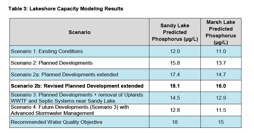
Identifying lake water quality trends and effective monitoring strategies in a rapidly urbanizing region
Doucet, C., 2022, [Master of Applied Science, Dalhousie University]. http://hdl.handle.net/10222/82119. The thesis gas two Results Chapters. Chapter 2,  Chapter 3: Tracking trophic state in urban lakes in a changing climate: are existing monitoring protocols still effective?

Sandy Lake Watershed Study Final Report
AECOM, 2014. 131 pages. History, maps etc.  Also view Lakeshore Capacity Modeling Results, Revised Planned Development extended . Also view Halifax Regional Municipality Watershed Studies Preston Area and Sandy Lake AECOm Slide Presentation by Russel Dmytriw at the Regional Watershed Advisory Board
March 12, 2014.

Sandy Lake Watershed Study – Additional Modeling Scenario
A letter dated Feb 12, 2015 addressed to Mr. Cameron Deacoff, Planning and Infrastructure Halifax Regional Municipality from Steve Murphy, MBA, P.Eng. Senior Manager, AECOM/Atlantic Canada. It has not been published on the HRM website or otherwise made available but was listed amongst info documents given to consultants reviewing the ‘Optimal boundaries for Sandy Lake Regional Park (see Post, Nov 10, 2021). The consultants made a preliminary report to HRM 7 stakeholders on mar 29, 2022, at which time the document was made available. Amongst the results: “The results of the Lakeshore Capacity Modeling for the Scenario 2b suggests the phosphorus concentrations in both Sandy Lake and Marsh will exceed the Water Quality Objectives set in the
Sandy Lake Watershed Study Final Report (AECOM 2014).

Halifax Regional Municipality Water Quality Monitoring Policy and Program Development
Prepared by: AECOM Canada Ltd., Sep 2020 99 pages + Appendices. Some context. Sandy Lake is cited as a “Priority Lake” for monitoring, with 2 of 3 water quality issues – Eutrophication and Bacteria –  by the following criteria:

Priority Eutrophication Lakes – lakes with elevated surface water TP concentrations during the ice-free period that are indicative of eutrophic conditions (i.e., >20 μg/L) based on a high-level review of monitoring data from select sources, and lakes with documented past issues with algal blooms or nuisance aquatic plant growth.

Priority Chloride Enrichment Lakes — lakes with elevated spring surface water chloride concentrations (i.e., >100 mg/L) that are approaching the Canadian Water Quality Guideline (CWQG) of 120 mg/L for long-term exposure for freshwater aquatic life, based on a high-level review of monitoring data from select sources.

Priority Bacteria Contamination — lakes with municipal beaches where HRM provides
supervision due to human health risks from recreational body contact with water.

The effects of land use changes on water quality of urban lakes in the Halifax-Dartmouth region: Sandy Lake
Pages from Paul Mandel, MSc thesis, Dalhousie University, 1994. Observations on Sandy Lake on 4 dates 1991/1992, and comparison with 1971 data.

Sandy Lake Development Impact Assessment Final Report – A Water Quality Analysis
Damon Conrad, Hany Sidhom, Steve Matthews, W. Hart 2002
“This report, created by senior Environmental Engineering students from Dalhousie University in 2001-02, involves the examination of Sandy Lake and surrounding area, in Bedford, Nova Scotia. Due to developmental pressures in the area from the major metropolitan area of Halifax Regional Municipality (HRM), Sandy Lake is of concern
regarding its relatively undeveloped shoreline. The initiating factor of this report is a beach and park project to be developed by HRM, which started construction in 2001 and will be completed over the following few years. This report involves the creation of baseline data including dissolved oxygen, pH, total suspended solids, a bathymetric map of the lake, total and fecal coliform, as well as other water quality parameters…. This report was intended to be retained for the purpose of maintaining a historic record of Sandy Lake and its surrounding area as well as to outline environmentally responsible practices regarding any future development.”

Water Quality Monitoring in the Sackville River Watershed 2015 and 2016
Bill Ernst and Damon Conrad, Sackville Rivers Association November 2016.

Establishing realistic management objectives for urban lakes using paleolimnological techniques: an example from Halifax Region (Nova Scotia, Canada)
Brian K. Ginn et al., 2015 Lake and Reservoir Management, 31:2, 92-108 “To determine pre-disturbance limnological conditions, evaluate the impact of environmental stressors (surface water acidification, nutrient inputs, climate change, and winter deicing salt), and set realistic recovery targets for lake management strategies, a rapid assessment paleolimnological approach was used to determine the amount (and likely causes) of environmental changes over the past ∼100–150 years in 51 urban lakes from Halifax, Nova Scotia (Canada). Diatom assemblages from lake sediment cores were used with “top” (recently deposited, surface) samples being matched to measured limnological conditions, and “bottom” (generally from >15 cm deep) samples used to infer pre-disturbance limnological conditions such as pH, total phosphorus (TP), specific conductance, and shifts due to changing climatic conditions. Environmental change was assessed by calculating the metric of change in species composition between present-day and pre-disturbance diatom assemblages, and inferences from quantitative estimates of diatom-inferred pH, specific conductance, and TP. All 51 study lakes have experienced floristic changes in diatom species composition since pre-disturbance times, but different environmental stressors were implicated: 8 of the 51 lakes underwent significant (i.e., >2 times the root mean-squared error [2X RMSE] of the inference model) decreases in diatom-inferred pH; 8 lakes had significant increases in diatom-inferred TP; and 19 otherwise relatively pristine lakes had increases in planktonic taxa consistent with observations linked to changes in lake seasonality and limnological changes most closely linked to climate warming in Nova Scotia and other regions. The remaining 16 lakes did not have large and consistent changes in diatom flora or changes in diatom-inferred TP or pH >2X RMSE of the prediction of the models. Lake-specific factors were related to these inferences, and the lakes that acidified were mainly the currently most acidic sites, whereas those that experienced issues related to eutrophication were generally among the most alkaline sites. Of our 51 lakes, 22 (including some experiencing pH, TP, or showing floristic changes linked to climate changes) had increases in measured conductivity (1980–2002) and, correspondingly, increased relative abundances of halophilic diatom taxa. These lakes, often with catchments containing high surface areas of impervious surfaces, are examples of a trend of increasing salinity in northeastern North American lakes likely related to winter application of deicing (road) salt. The application of this paleolimnological approach enabled us to identify which lakes have undergone significant changes in diatom assemblages, as well as which environmental stressor(s) were most probable. This information can help lake managers develop more targeted and effective management strategies.” Sandy Lake was one of the “19 otherwise relatively pristine lakes had increases in planktonic taxa consistent with observations linked to changes in lake seasonality and limnological changes most closely linked to climate warming in Nova Scotia and other regions.” Sampling: “Sediment cores were collected from 51 lakes in Halifax Region in July 2005 and July 2006”

SACKVILLE RIVER WATERSHED WETLAND INVENTORY PT. 2: BIG SANDY LAKE SUB-WATERSHED
John-William Brunner/Sackville Rivers Association. 2011. Prepared for the Nova Scotia Department of Transportation and Infrastructure Renewal (NSTIR-ESS File: 17.008.09) Describes 7 sites. Farmer’s Dairy Site on Goggle Earth here
Full Report: Sackville River Watershed Wetland Inventory
:Wet Area Mapping (WAM) data was acquired and assessed in the field to identify and inventory wetland and wet area sites to locate areas for wetland creation, enlargement, and enhancement. These sites could be used for potential future wetland compensation projects in the Sackville River Watershed (SRW). The inventory project was initiated as part of the compensation for damaged wetlands from new interchanges on Highway 101 and 102 and the new French high school in the Halifax Regional Municipality. The WAM data was found to be accurate in identifying wet areas in the surveyed portions of the SRW. Three of the SRW’s most urbanized sub-watersheds were field inventoried and revealed non-wetland wet areas as well as new, potential, and existing wetlands. These areas yielded the possibility for a total of 142,743 square meters of wetland creation, restoration, and enhancement. The remaining 10 sub-watersheds require 6 months of GIS work, field work, and report writing which could reveal approximately 100 additional wetland creation, enlargement, and enhancement sites.”

Peverill’s Brook – An Atlantic Salmon Conservation Foundation and Adopt-a-Stream Sponsored Project
“At Peverill’s Brook this summer, we measured the area that needed and could be worked on to determine the amount of digger logs we could install. Among all of our other work, this summers crew (2012) managed to install eleven logs along Peverill’s and enhanced one natural rock sill. We divided the stream into a lower and upper section, between which lies marsh lake. These before and after pictures clearly illustrate the narrowing of the channel widths, and when the water is high, how much oxygen gets plunged into the river as pools get dug out for the fish.”

Invertebrate Predation and the Seasonal Dynamics of Microcrustacea in the Littoral Zone of Jack Lake, Nova Scotia
Michael J. Paterson PhD thesis, Dalhousie University

Characterizing Sources of Fecal Pollution at Four Urban Public Beaches in the Halifax Regional Municipality
Michael McDonald, 2016. MSc thesis “Within the last few years several beaches in the Halifax Regional Municipality have closed frequently due to increased levels of E. coli within the beach waters. Enumeration, microbial enrichment, and genetic microbial source tracking methods were used to enumerate E. coli levels and detect the presence of select pathogens and host-specific fecal contamination markers within four local freshwater urban beaches. E. coli levels mostly remained below the maximum allowed concentration throughout the sampling season. Tested pathogen and fecal contamination markers displayed a low prevalence. E. coli levels were influenced by measured water quality parameters and were shown to fluctuate on a day-to-day basis. However, E. coli were unable to predict the presence of enteric pathogens or fecal contamination markers. The beaches do not appear to be heavily contaminated and should generally be safe for public use. The use of E. coli as a fecal indicator needs to be further assessed in future studies.” Sandy lake was one of the study lakes, “chosen as a control beach due to a history of good water quality and location in a relatively unpopulated area”. He looked specifically for dog contamination, concluding Overall, the low prevalence of the BacCan marker indicates that dogs may not be a large source of contamination at the tested beaches and the ban on dog’s access to beaches imposed by the HRM is being obeyed.”

Sackville Rivers Association (SRA) (website)
The Sandy Lake watershed is a subwatershed of the Sackville River watershed. The SRA is a highly active organization which works to
1) Protect and where necessary restore the environment of the Sackville River Watershed
2) Raise awareness about the environment of the Sackville River watershed and its adjacent watersheds
3) Establish a Conservation Corridor along the length of the Sackville River
4) Provide training and advice to community groups in other watersheds as needed, to restore the environment and raise environmental awareness

SANDY LAKE, Bedford:- Accelerated eutrophication signs, and suggested restoration parameters
S. M. Mandaville to Chair & Members, North West Community Council, HRM, October 30, 2013 “I include the predictive phosphorus modelling conducted by my team some years back
(results updated in page-5, and the pictorial model in page-7). The enrichment has already occurred (see page-3 on suggested action by the NWCC)…The goal of restoration should be a maximum deep station TP of 9 μg/l”. Also view Excel file for Sandy Lake


Natural Freshwater Lakes and Ponds in New Hampshire: Draft
Nichols, W. F. 2015.NH Natural Heritage Bureau. Includes descriptions of wetland vegetation in relation to lake & pond trophic status

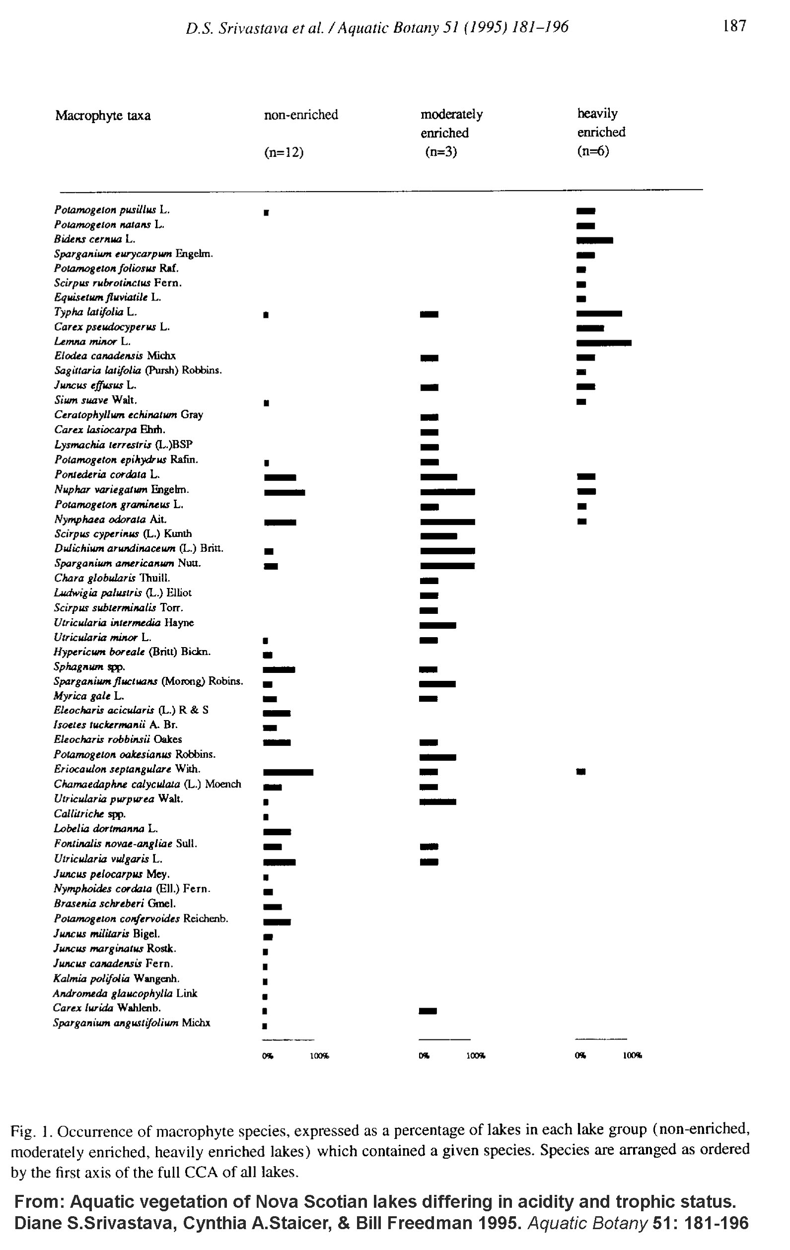
Aquatic vegetation of Nova Scotian lakes differing in acidity and trophic status
Diane S.Srivastava, Cynthia A.Staicer, & Bill Freedman 1995. Aquatic Botany 51: 181-196 “Aquatic macrophytes of the littoral zone were surveyed in 21 Nova Scotian lakes, and macrophyte composition was interpreted in relation to chemical and physical characteristics. The lake set included both nutrient-enriched and acidified lakes, and consequently had a wide range of water chemistry variables, notably pH (3.7–8.3) and total phosphorus (0.003–6.0 mg l−1). Using canonical correspondence analysis, we related differences in vegetation among lakes to 14 water chemistry and three physical variables. Alkalinity, total phosphorus, and total nitrogen were most strongly correlated with differences in vegetation between heavily enriched, moderately enriched and non-enriched lakes. Interestingly, macrophyte composition was not strongly correlated with pH. Even in a subset of lakes consisting of moderately enriched and non-enriched lakes, alkalinity, total phosphorus and total nitrogen remained strongly correlated with vegetation differences. By contrast, vegetation differences among non-enriched laks correlated most strongly with substrate slope, lake area, calcium, and alkalinity.” View Figure 1 showing species in relation to trophic status

WALKING THE RIVER A Citizen’s Guide to Interpreting Water Quality Data
NS salmon Association/NSLC Adopt-a-Stream Program. 2014. Detailed 43 page pdf. Especially helpful on interpreting water quality data.

NSLC Adopt A Stream
The NSLC Adopt A Stream Program provides funding and technical support to help community volunteer organizations undertake projects to protect, repair and improve the aquatic and riparian habitats of local wetlands, lakes, streams, rivers and estuaries in Nova Scotia. Excellent Project Resources:
Nova Scotia Adopt A Stream Manual
Fish Habitat Restoration Methods
Interpreting Water Quality
SandWand
Aquatic Connectivity Analytical Database
Also items under Training, e.g.
Culvert Assessment for Fish Passage
Habitat Suitability Assessment
The Nova Scotia Fish Habitat Assessment Protocol- June 2018.pdf

Stream Classification
Slideset at csmgeo.csm.jmu.edu attributable to Scott Eaton.

Methods for evaluating wetland condition #7 Wetlands Classification
U.S. EPA, 2002.

“WALKING THE RIVER” A Citizen’s Guide to Interpreting Water Quality Data
Nova Scotia Salmon Association NSLC Adopt-a-Stream Program April 2014 Version

Principles and Guidelines for Ecological Restoration in Canada’s Protected Natural Areas
National Parks Directorate, Parks Canada Agency Gatineau, Quebec. 2008

Fish Friends 2019 final Report
Sackville Rivers Association

Field guide to algae and other “scums” in ponds, lakes, streams and rivers
Miriam Steinitz Kannan and Nicole Lenca, Northern Kentucky University 2013

Cyanobacteria Presence in Four Lakes in the Halifax Regional Municipality (HRM), Nova Scotia
Betts, Rebecca A. Dalhousie University Graduate thesis 2018. “The major objective of this project is to assess the presence of cyanobacteria (organisms that can pose serious challenges for drinking water treatment systems), in Halifax water supplies using DNA typing to identify cyanobacteria species. Four lakes in the Halifax Regional Municipality (HRM), NS, were chosen due to their differing water chemistry. A total of 35 taxa of cyanobacteria and one taxa of unassigned bacteria were detected, of which, 15 genera of cyanobacteria were identified. Of those genera, 11 have been associated with cyanotoxins, which are harmful to humans and animals. Supplementary data showed that two of the four lakes had higher pH, alkalinity, TN, TP and turbidity means than the others, and had detectable cyanotoxins and algal blooms after periods of rain followed by long periods of warm, dry, relatively calm weather. This thesis will provide a foundation for future experiments into lake and cyanotoxin management.”

Coastal Action Publications
“Coastal Action, established in December 1993, is a charitable organization that addresses environmental concerns within the South Shore region of Nova Scotia. Our goal is to promote the restoration, enhancement, and conservation of our environment through research, education, and action. Coastal Action is currently tackling many environmental issues that fall under the following theme areas; species at risk and biodiversity, watersheds and water quality, climate change and education, as well as coastal and marine.”
Some of the publications:
Watershed Wisdom
In-stream structures: Digger Logs
In-stream structure: Deflectors
In-stream structures: Rock Sills
Save the LaHave Activity Booklet. and more

Connectivity of Streams and Wetlands To Downstream Waters: A Review and Synthesis of the Scientific Evidence (Final Report)
U.S. Environmental Protection Agency, Washington, DC, EPA/600/R-14/475F, 2015. “The report summarizes current scientific understanding about the connectivity of streams and wetlands to downstream waters. EPA has conducted a thorough review of the literature – more than 1,200 peer-reviewed and published documents – on the scientific evidence regarding the effects that streams, nontidal wetlands, and open -waters have on larger downstream waters such as rivers, lakes, estuaries, and oceans. The focus of the report is on surface and shallow subsurface connections by which small or temporary streams, nontidal wetlands, and open waters affect larger waters such as rivers, lakes, reservoirs, and estuaries. EPA, along with other federal agencies and states, can use this scientific report to inform policy and regulatory decisions, including the Clean Water Rule being developed by EPA and the U.S. Army Corps of Engineers.”

Also published as CONNECTIVITY OF STREAMS AND WETLANDS TO DOWNSTREAM WATERS: AN INTEGRATED SYSTEMS FRAMEWORK
Scott G. Leibowitz et al., 2018. J Am Water Resour Assoc.  54(2): 298–322.

Eutrophication and restoration in temperate lakes
L. May et al., 2019. at International Conference on Tropical Limnology 2019. IOP Conf. Series: Earth and Environmental Science 535 (2020). A review of the basics.


PHOSPHORUS

Lake Tropic Status
RMB Environmental Laboratories. Basic Into. Other topics related to the physical, chemical and biological components of lakes are covered in their Lake Primer

Defining Trophic State
North American Lake Management Society. A more in-depth explanation.

A trophic state index for lakes
RE Carlson 1977 LImnology and Oceanography “A numerical trophic state index for lakes has been developed that incorporates most lakes in a scale of 0 to 100. Each major division (10, 20, 30, etc.) represents a doubling in algal biomass. The index number can be calculated from any of several parameters, including Secchi disk transparency, chlorophyll, and total phosphorus.”

Trophic response to phosphorus in acidic and non-acidic lakes in Nova Scotia, Canada
J Kerekes et al., 1990 Hydrobiologia 191, pages105–110 “Twenty lakes (oligotrophic or eutrophic) with a wide range of acidity (pH 3.5 to 7.6) show a typical trophic response to total phosphorus with respect to algal biomass (OECD relationship), irrespective of their acidity. Zooplankton abundance is also related to total phosphorus, except for an outlier lake which is very acidic and eutrophic. This lake, however, has an abundant benthic and pelagic insect fauna and shows an overall ‘normal’ trophic response to phosphorus. In three lakes where planktonic primary production at light optimum (P maxwas measured, it was highest in the most acid lake (pH 4.4) which has the largest total phosphorus concentration.”

User’s Manual for Prediction of Phosphorus Concentration In Nova Scotia Lakes: A Tool for Decision Making Version 1.0
M. Brylinsky, 2004. Prepared For The Nova Scotia Water Quality Objectives and Model Development Steering Committee Nova Scotia Department of Environment and Labour. 88 pages. As well as describing the use of this commonly used model, the document provides a basic introduction to phosphorus in aquatic systems cycling and the rationale for focussing on phosphorus to predict lake trophic status.

Sandy Lake Watershed Study Final Report
AECOM, 2014. 131 pages. Comprehensive review of what’s known about Sandy Lake and Marsh lakes and area, and desktop modelling of impacts of development on phosph0rus levels. View also the Response of Sandy Lake Conservation Association (SLCA) to this report.

Pollution Source Control Study for Lake Banook & Lake Micmac Final Report
Stantec Consulting Ltd. for Halifax Regional Municipality, 2019. The same P model was used as in the AECOM report but with a lot of field observations included.

Non-floodplain Wetlands Affect Watershed Nutrient Dynamics: A Critical Review
Heather E. Golden et al., 2019.Environmental Science & Technology 53 (13), 7203-7214 “Wetlands have the capacity to retain nitrogen and phosphorus and are thereby often considered a viable option for improving water quality at local scales. However, little is known about the cumulative influence of wetlands outside of floodplains, i.e., non-floodplain wetlands (NFWs), on surface water quality at watershed scales. Such evidence is important to meet global, national, regional, and local water quality goals effectively and comprehensively. In this critical review, we synthesize the state of the science about the watershed-scale effects of NFWs on nutrient-based (nitrogen, phosphorus) water quality. We further highlight where knowledge is limited in this research area and the challenges of garnering this information. On the basis of previous wetland literature, we develop emerging concepts that assist in advancing the science linking NFWs to watershed-scale nutrient conditions. Finally, we ask, “Where do we go from here?” We address this question using a 2-fold approach. First, we demonstrate, via example model simulations, how explicitly considering NFWs in watershed nutrient modeling changes predicted nutrient yields to receiving waters–and how this may potentially affect future water quality management decisions. Second, we outline research recommendations that will improve our scientific understanding of how NFWs affect downstream water quality.”

How effective are created or restored freshwater wetlands for nitrogen and phosphorus removal? A systematic review
Magnus Land et al., 2016.Environ Evid 5, 9 Conclusions On average, created and restored wetlands significantly reduce the transport of TN and TP in treated wastewater and urban and agricultural runoff, and may thus be effective in efforts to counteract eutrophication. However, restored wetlands on former farmland were significantly less efficient than other wetlands at TP removal. In addition, wetlands with precipitation-driven HLRs and/or hydrologic pulsing show significantly lower TP removal efficiencies compared to wetlands with controlled HLRs. Loading rate (inlet concentrations × hydraulic loading rates) needs to be carefully estimated as part of the wetland design. More research is needed on the effects of hydrologic pulsing on wetlands. There is also a lack of evidence for long-term (>20 years) performance of wetlands.

Phosphorus Retention in Streams and Wetlands: A Review,
K. R. Reddy , R. H. Kadlec , E. Flaig & P. M. Gale (1999) Critical Reviews in Environmental Science and Technology, 29:1, 83-146,

Reducing Phosphorus to Curb Lake Eutrophication is a Success
David W. Schindler et al., 2016 Environ. Sci. Technol. 2016, 50, 17, 8923–8929 “As human populations increase and land-use intensifies, toxic and unsightly nuisance blooms of algae are becoming larger and more frequent in freshwater lakes. In most cases, the blooms are predominantly blue-green algae (Cyanobacteria), which are favored by low ratios of nitrogen to phosphorus. In the past half century, aquatic scientists have devoted much effort to understanding the causes of such blooms and how they can be prevented or reduced. Here we review the evidence, finding that numerous long-term studies of lake ecosystems in Europe and North America show that controlling algal blooms and other symptoms of eutrophication depends on reducing inputs of a single nutrient: phosphorus.”

Nutrient removal effectiveness by riparian buffer zones in rural temperate watersheds: The impact of no-till crops practices
T.R.Aguiar Jr. et al., 2015 Agricultural Water Management 149: 74-80 “…buffer zones with 60 m width composed of woody soils were more effective in phosphorus (99.9%) and nitrogen (99.9%) removal when compared to shrub (66.4% and 83.9%, respectively) or grass vegetation (52.9% and 61.6%, respectively) areas. Woody vegetation has deep rooting systems and woody soils have a higher content of organic matter when compared to grass and shrubs areas.”

Small differences in riparian vegetation significantly reduce land use impacts on stream flow and water quality in small agricultural watersheds
J.W. Chase et al. 2016 Journal of Soil and Water Conservation May 2016, 71 (3) 194-205. “… In northwest New Brunswick’s potato (Solanum tuberosum L.) growing region, once densely forested riparian corridors now often contain only scattered, irregular patches of residual vegetation, and national water quality standards for streams are regularly exceeded. The objective of this study was to ascertain whether relatively small differences in riparian forest cover are of any significant benefit to stream environments…. Our results conclusively show that relatively small increases in riparian forest cover will lead to statistically detectable and ecologically meaningful improvements to stream health.”

ON ANOXIA  &  INTERNAL P LOADING

Quantifying anoxia in lakes
By G.K. Nurnberg 1995 in Limnology & Oceanography. PDF “Abstract
The anoxic factor (AF, days per year or per season) can be used to quantify anoxia in stratified lakes. AF is calculated from oxygen profiles measured in the stratified season and lake surface area (A,) asAF = (duration of anoxia x anoxic sediment area)/& AF represents the number of days that a sediment area, equal to the whole-lake surface area, is overlain by anoxic water. Average AF for 56 central Ontario lakes, 19 additional eastern North American lakes, including the Laurentian Great Lakes and several acidified lakes, ranged from 0 to 83 d per summer…Annual variation within lakes was large and partly ascribed to variable annual loading of DOC. AF was not correlated with areal hypolimnetic oxygen depletion, because of the opposing dependency on lake shape, but was correlated with Reckhow’s probability of anoxia in eutrophic lakes. AF was also correlated with the redox potential of anoxic water at the end of summer stratification, especially after inclusion of an estimate of iron concentration in the sediment.”  She classified anoxic water as water with 1 mg/L and less oxygen; under some circumstances, 2 mg/L and less.

Internal phosphorus loading in Canadian fresh waters: a critical review and data analysis
DM Orihel et al., 2017. Can. J. Fish. Aquat. Sci. 74: 2005–2029.

Rivers and Streams: Life in Flowing Water
By: Declan McCabe © 2011 Nature Education in Nature Education Knowledge 3(10):19 Learning Resource. “What lies beneath? Rivers: diverse habitats with broadly varying niches. Communities reflect and influence local, upstream, downstream, and broader landscape conditions.”

Recovery Strategy and Management Plan for Multiple Species of Atlantic Coastal Plain Flora in Canada
Environment Canada and Parks Canada Agency. 2010 96 pp. + appendices.

Riparian Buffer Removal and Associated Land Use in the Sackville River Watershed, Nova Scotia, Canada
By Emily Rideout Submitted for ENVS 4901/4902 – Honours April 5, 2010
Abstract
“To what extent has riparian area been removed in the Sackville River watershed and what land uses are associated with this riparian area removal?” I investigate this question by assessing the extent of riparian area removal in the Sackville River watershed north of Halifax and characterizing each riparian impact zone with the neighbouring land use. Stream, lake and road data and air photographs are used in Geographic Information Systems (GIS) to document the degree of riparian area removal and the land uses associated with the riparian area (agriculture, industry, forestry, residential etc). I consider the riparian area to be a 20m zone extending from the water body’s edge. Over 143km of streams are assessed and all streams are broken down into reaches of discrete lengths based on riparian impact and land use category. Four qualitative indicators of riparian removal are used: Severe, Moderate, Low and Intact. The length of every reach as well as the degree of impact and associated land use are calculated using the summary statistics function in GIS. I found that one third of the total riparian area length is missing up to 50% of its vegetation and that residential, transportation and energy infrastructure were the leading drivers of this riparian buffer removal. I present a map of impacted riparian “hot spots” that will highlight the areas in which riparian area removal is the most severe as well as summaries of the land uses most associated with the greatest degree of riparian vegetation removal. Identification of the land use drivers of riparian area removal in this watershed will help the design of effective regulations for future development in riparian buffer zones.

Natural and Manmade Variations in Groundwater Flow and Chemistry in the Birch Cove and Sackville Areas of Halifax County, Nova Scotia
Cross, Heather J. 1974 MSc thesis Dalhousie University
This study discusses the groundwater flow and quality in the Birch Cove and Sackville areas of Halifax County, Nova Scotia, as related to geology and urban influence…. Notes roadsalt in groundwater

The Implications of the Emerald Ash Borer (Agrilus planipennis) on Riparian Canopy Cover in Three Halifax Regional Municipality Parks
Dalhousie Univ. Environmental Science Honours Thesis 2020, Jordan Haughn

Water Quality Monitoring in HRM Lakes
Environment & Sustainability Standing Committee December 7, 2020

OXYGEN/HABITAT for COLD-WATER FISH
Widespread deoxygenation of temperate lakes
Stephen F. Jane et al., Nature 594: 66-70. Abstract….The long-term declines in dissolved oxygen concentrations in coastal and ocean waters have been linked to climate warming and human activity6,7, but little is known about the changes in dissolved oxygen concentrations in lakes. Although the solubility of dissolved oxygen decreases with increasing water temperatures, long-term lake trajectories are difficult to predict. Oxygen losses in warming lakes may be amplified by enhanced decomposition and stronger thermal stratification8,9 or oxygen may increase as a result of enhanced primary production10. Here we analyse a combined total of 45,148 dissolved oxygen and temperature profiles and calculate trends for 393 temperate lakes that span 1941 to 2017. We find that a decline in dissolved oxygen is widespread in surface and deep-water habitats. The decline in surface waters is primarily associated with reduced solubility under warmer water temperatures, although dissolved oxygen in surface waters increased in a subset of highly productive warming lakes, probably owing to increasing production of phytoplankton. By contrast, the decline in deep waters is associated with stronger thermal stratification and loss of water clarity, but not with changes in gas solubility. Our results suggest that climate change and declining water clarity have altered the physical and chemical environment of lakes. Declines in dissolved oxygen in freshwater are 2.75 to 9.3 times greater than observed in the world’s oceans6,7 and could threaten essential lake ecosystem services.” Thx to Shalom Mandaville for forwarding this item – dp Aug 17, 2021. Comments Shalom: “The prime thought I have is that if the climate warming during 1941 to 2017 is the major factor, then other factors like nutrients are not major.”Nova Scotia Lake Hypolimnion Project
M. Brylinsky 2002 for Nova Scotia Department of Agriculture and Fisheries 53 pp SUMMARY A major limiting factor for book trout (Salvelinus fontinalis) in Nova Scotia is the presence of suitable cold-water habitat during summer. In an attempt to develop a model that could be used to predict the type of lake most likely to contain cold-water fish habitat during summer, 20 lakes distributed over a wide geographic area within Nova Scotia were surveyed during July and August 2001. The lakes were chosen on the basis of data contained in the Province’s lake survey database, and included 11 lakes that contained cold-water habitat and 8 lakes in which coldwater habitat was absent during the time of the original survey. Suitable cold-water habitat was defined as water temperature ≤15 °C and dissolved oxygen saturation ≥50 % [to maintain oxygen ≥5 mg/L]. The major parameters measured during the 2001 survey were indices of trophic state (total phosphorus concentration, chlorophyll a concentration and Secchi Disk depth), and water temperature and dissolved oxygen depth profiles.The results indicate that there was relatively little difference between the July and August surveys in determining the status of a lake with respect to the presence of cold-water habitat. There was, however, considerable difference between the status of the lakes based on the original survey data, some of which was collected more than 25 years ago, and the data obtained during the 2001 surveys. Only two of the lakes surveyed during 2001 contained suitable coldwater habitat. It was not possible to determine conclusively, based on the data available, if these changes are a result of changes in trophic state or other factors.The two lakes that contained suitable cold-water habitat during 2001 were the deepest lakes surveyed. This suggests that an important factor in determining the presence of cold-water habitat is the relative proportions of the epilimnetic and hypolimnetic volumes, a factor that was not fully appreciated when this study was initiated.Predicting oxygen profiles in Nova Scotia brook trout lakes using the Lakeshore Capacity Model: considerations for brook trout habitat, remediation and future development
C. Soliman, P.J. Dillon, J. Aherne & D. Lasenby 2009. Internationale Vereinigung für theoretische und angewandte Limnologie: Verhandlungen, 30:7, 1137-1140

Discussion
This study shows that the Ontario LCM oxygen model can be used to accurately predict hypolimnetic oxygen profiles for lakes in Nova Scotia. BRYLINSKY (2002) studied 20 previously-stocked brook trout lakes, 11 classified as good and 9 classified as having poor cold- water fish habitat. A later survey of the same lakes showed that only 2 provided suitable habitat (Millet and Frenchclearwater lakes); however, the measurements in these lakes (e.g., Frenchclearwater Lake) did not include all of the hypolimnion. Our study did not con- sider Frenchclearwater Lake as suitable habitat based on predicted VWHOC. This discrepancy could be attributed to BRYLINSKY (2002) not collecting DO measurements below 10 m, while the lake is 21 m deep, with the thermocline beginning at 12 m. Other researchers have utilized a limit of DO concentrations > or = 3 mg/L for coldwater fish habitat (STEFAN et al. 1995, FANG et al. 2004). Using this limit, 3 of the study lakes have good habitat: Millet, Lumsden and Long lakes.

Hincast, pre-development TP concentration (Table l) could be used as an indicator of potential brook trout habitat and to set restoration goals. Habitat remediation should best focus on lakes showing evidence of historic coldwater fish habitat. In this study, not only did current measurements indicate poor habitat quality, but hindcast water quality did not indicate good historic coldwater fish habitat for any of the lakes (VWHOC > or = 5 mg/L). These are worrisome results, as the province re-stocks these lakes every year. In the long term, it may be more economical for managers to consider introducing self- sustaining populations in lakes where good habitat exists or to restore water quality in lakes where good habitat once existed.

Based on this study, Nova Scotia now has useful tool for predicting the VWHOC for stratified lakes. This model can be used to develop realistic remediation goals based on hindcast, pre-development TP concentrations, in hopes to better manage brook trout populations.

Predicting End-of-Summer Oxygen Profies in Stratified Lakes
LA Malot et al., 1992. Canadian Journal of Fisheries and Aquatic Sciences
Mean end-of-summer dissolved oxygen profiles in the hypolimnion of oligotrophic and oligornesstrophic thermally stratified lakes were accurately predicted with a multivariate regression model. The model integrates the effects of lake morphometry, total phosphorus concentration (TP), and initial O2 concentrations at spring turnover to predict mean end-of-summer O2 concentration within individual hypolimnetic strata. Lake morphometry exerts a large influence on O2 profiles and this influence is particularly evident in shallow (<20 m maximum depth) oligotrophic lakes. Predictions sf O2 profiles are sensitive to changes in TP concentrations, with all study lakes predicted to have severely 0,-depleted hypolimnions by the end of summer at an epilimnetic TP of only 15 ug/L .

Predicting the location of optimal habitat boundaries for lake trout (Salvelinus namaycush) in Canadian Shield lakes
PJ Dillon et al., 2003. Canadian Journal of Fisheries and Aquatic Sciences “The optimal habitat boundary for lake trout (Salvelinus namaycush Walbaum) has been defined as that portion of the lake having both more than 6 mgL–1 oxygen and temperature less than 10 °C. Here we use an existing hypolimnetic oxygen model to define the lower boundary of the optimal habitat by identifying the depth at which 6 mgL–1 oxygen occurs at the end-of-summer stratification period. Then we develop a new model to predict the 10 °C depth or upper habitat boundary for the same date. These two boundaries can be used in conjunction with measured individual strata volumes to calculate the optimal habitat volume. Parameters needed for the models include lake morphometry, total phosphorus (TP) concentration, and Secchi depth or dissolved organic carbon (DOC) concentration. Thus, the optimal habitat model can be used to predict the effects on optimal habitat volumes of changes in trophic status (increases or decreases in TP), or changes in light transmission (caused by changes in DOC or its surrogate in these lakes, i.e., Secchi depth) that result from changes in climate, land use, acid–base status, or incident ultraviolet radiation levels.”

Lake classification in Nova Scotia from phosphorous loading, transparency and hypolimnetic oxygen consumption
Schwartz, P. Y. and Underwood, J. K. Proc. Nova Scotian Institute of Science 1986. “Three indices of eutrophication are used to compare effects of urbanization on seven headwater lakes near Halifax, Nova Scotia. Annual (1983) inputs of phosphorus were calculated and compared with lake Secchi transparencies and rates of consumption of hypolimnetic oxygen (Thienemann index). Results from transparency and oxygen deficits were similar but implied greater eutrophication than did the phosphorus index. Brief discussion of some inherent problems of each index is included.

Water on the Web
A comprehensive set of learning materials developed under auspices of U.S. National Science Foundation 1997-2005
See for example:
Lake Ecology Primer
Water Science Curriculum

Understanding Lake Quality
US EPA 57 page pdf.

Focus on freshwater conservation, and land gets swept along for the ride
By Cara Giaimo for www.anthropocenemagazine.org, Nov 11, 2020 “Prioritizing terrestrial species leaves freshwater ones behind — but the opposite isn’t true.”

Helping fish cross the road in New Brunswick
World Wildlife Fund, Feb 25, 2021 “How did the fish cross the road? It was a culvert operation! While that may be pretty funny, clogged culverts — those small tunnels that go under roads to allow water to pass — are no joke. A single poorly installed or degraded culvert can block many kilometres of high-quality feeding and spawning habitat, isolate fish populations and restrict species migration to safer areas.”

Watersheds Canada Resources: Lake Protection Workbook
“Check out the “Lake Protection Workbook: A Self-Assessment Tool for Shoreline Property Owners”, created by the Lake Links Planning Committee. [2019] Diagnose any shoreline property problems, and see how you can help your shoreline”