
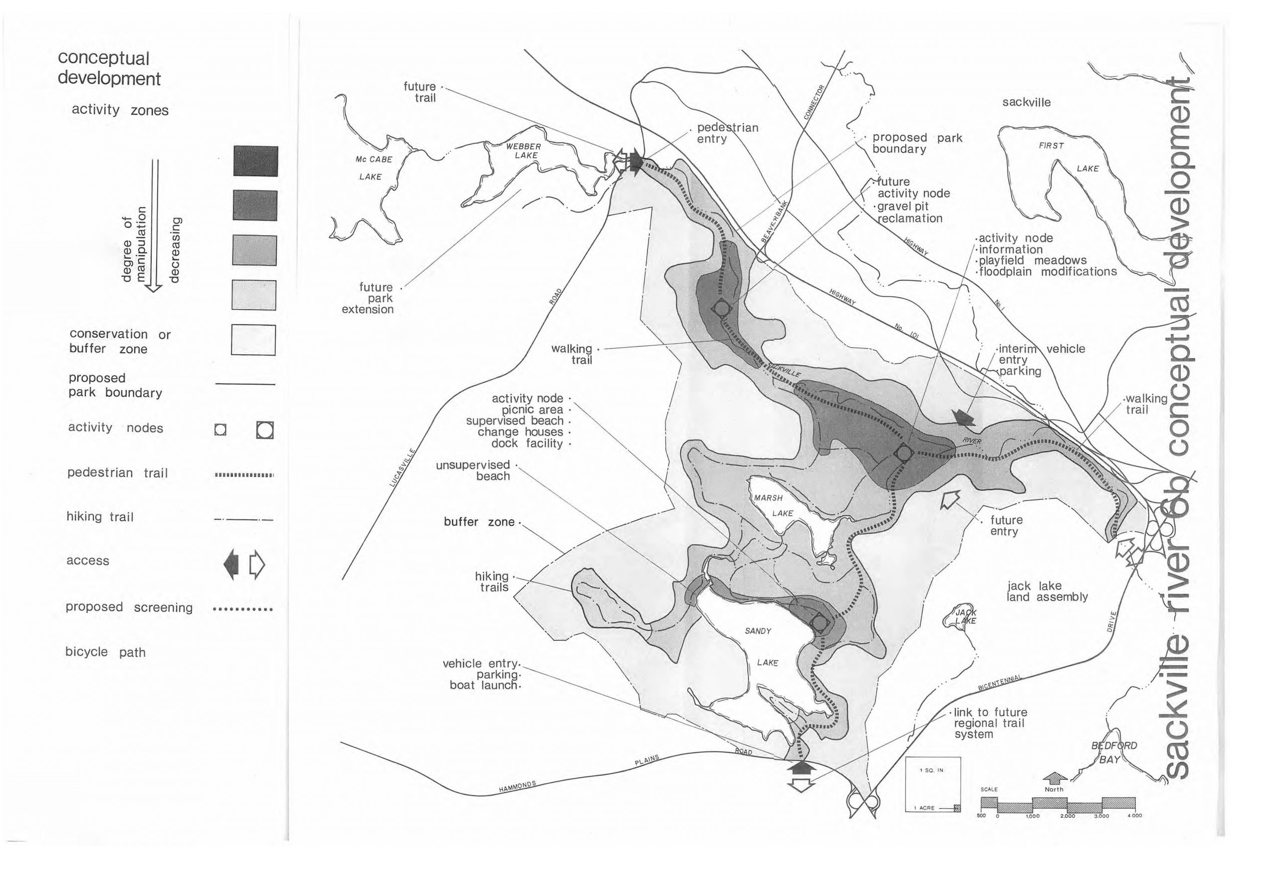
Sackville River Regional Park as envisaged in a 1979 report. (Click on image for a larger version ).View 1979 Report. View website for the Sandy Lake – Sackville River Regional Park Coalition for the current vision of this park.
UPDATE June 21, 2023: A set of Independent observations I have just learned about are consistent with our observations of low oxygen at depth, and additionally provide evidence of internal P loading. See below
UPDATE June 17, 2023: Clarification of “algal bloom” (2019) and “BGA warning” (2022)
——
Update June 16, 2023: Water quality in Bedford’s Sandy Lake at ‘precarious levels,’ retired Dalhousie biology prof says Yvette D’Entremont in the Halifax Examiner, June 16, 2023
——
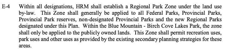
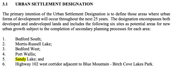
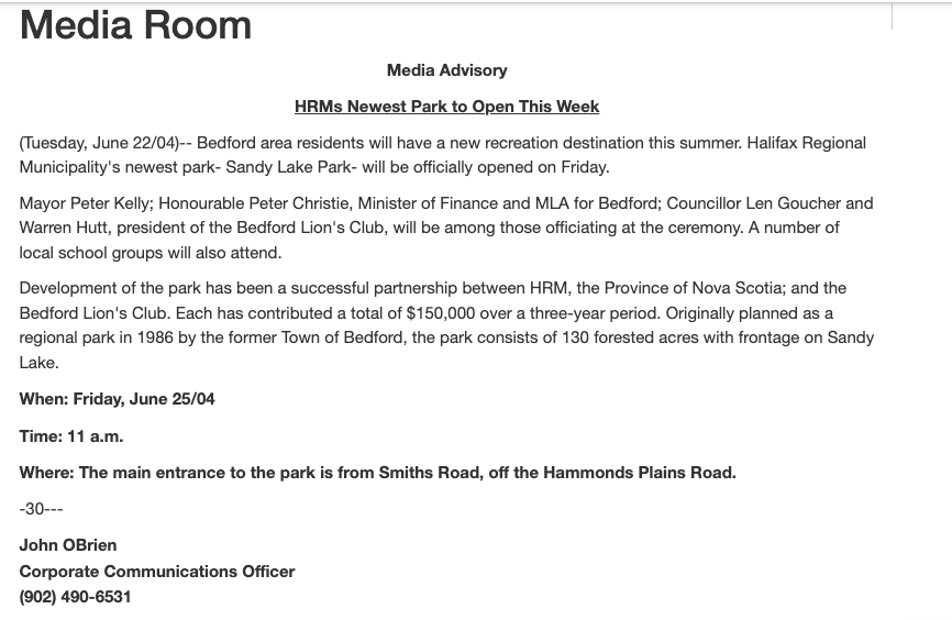
The concept of a ‘Sandy Lake-Sackville Regional Park’ harks back to the 1970s, It would encompass lands surrounding Sandy and Marsh Lakes and the adjacent lands by the Sackville River (see map at right). In our first (2006) Regional Plan, reference was made to “Jacks Lake Park” as an “Additional Regional Park” focussed on the east side of the lake. There was reference to an existing “Sandy Lake Regional Park” – 130 forested acres on the east side of Sandy Lake officially opened in 2004 as the “Sandy Lake Park” – but lands to the west of Sandy Lake were given an “Urban Settlement” designation, meaning they were identified as an area for future growth (housing) in HRM, not conservation & recreation. (For more details see “2006 Regional Plan Note” at the bottom of this post).
The Urban Settlement designation set in motion a requirement for a watershed study under Policy E-17 of the 2006 Regional Plan (see pp 44-52 in AECOM 2014 for details).
The desktop study (except for a few water samples taken in 2013), requested in June 2013, was completed Aug 25, 2014. From AECOM 2014:
The primary, overarching objective of the Sandy Lake Watershed Study, as expressed in Regional Plan Policy E-17,
is to: “…determine the carrying capacity of the watersheds to meet the water quality objectives which shall be adopted following the completion of the studies.”Carrying capacity is a measure of the watershed’s ability to accommodate inputs from both man-made and naturally occurring pollutants without experiencing a significant decline in water quality and ecological function. In this study, different land development scenarios are evaluated to understand the potential water quality effects resulting from each scenario. The outcome of the study is to provide a number of guidelines and recommendations for the planning, design and implementation of new developments that will help to maintain existing water quality.
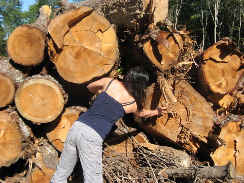
“In 2013, a large swath of land including Acadian old growth forest along the west side of Sandy Lake was suddenly clear-cut by a residential developer. (The land was subsequently sold to a different developer.) This action came as a surprise to residents as it was in an area originally designated for the Sandy Lake Regional Park. It became clear that rather than park land, those lands lying close to Sandy Lake could be developed with residences for as many as 16,000 people, and would add 8,000 vehicles to the Hammonds Plains Road.” SOURCE: Sandy Lake Conservation Association
AECOM (2014) used historic water quality info. and a few samples they collected in 2013 to “identify water quality objectives for parameters that are affected by development” and then applied a Lake Capacity Model “to predict how future development may impact the phosphorus concentrations of the lakes”.
They set the WQOs (Water Quality Objectives) for Total P at 50% above the “current values” for Total P (12 ug/L for Sandy Lake, 10 ug/L for Marsh Lake or 10.5 ug/L if they used their modelled current value). The resultant WQOs were 18 ug/L for Sandy Lake and 15 ug/L for Marsh Lake (or 15.5 ug/L if they used their modelled current value).
The Lake Capacity Model predicted Total P levels of 13-16 ug/L for Sandy Lake and 12 to 15 ug/L for Marsh Lake under 3 scenarios (Planned Development; Planned Development + Removal of Uplands WWTF and Septic Systems near Sandy Lake; Adding Advanced Stormwater Management), i.e. the predicted levels with development fell within or not far above the WQOs. (In a subsequently modelled scenario 2b (Revised Planned Development extended) the predicted values for Sandy Lake (18.1 ug/L) and Marsh Lake (16.0) slightly exceeded the WQOs.)
The Lake Capacity Model provides only a first approximation to reality.
Notes AECOM (2014):
The predictions from the phosphorus load model are consistent with observations of urbanization in other watersheds. However, the degree of influence of urbanization on water quality in Sandy Lake can only be approximated using the phosphorus load model because of limitations arising from assumptions and uncertainty in the application of the model. Therefore a robust water quality monitoring plan is proposed for the Sandy Lake watershed to provide a further assessment of current conditions and to evaluate the impacts of development on the water quality.
A robust water quality monitoring plan as recommended above was not initiated following the acceptance of the AECOM 2014 Report.
The major variable of interest in relation to phosphorus loading for stratified lakes such as Sandy Lake is the deep water oxygen levels. There is really no substitute for actually measuring those levels (rather than making a broad inference based on predicted &/or measured Total P levels) to assess actual lake health.
Beginning in 2017, I worked with two volunteers with the Sandy lake Conservation Association, Ed G and Derek S, to obtain three limnological profiles in the deepest area of Sandy Lake during the period of summer stratification in 2017, 2019 and 2022* and two profiles during the spring turnover period (2021, 2022). The variables, measured at 1 m or shorter intervals from top to bottom, were temperature, electrical conductivity (a measure of salt content) and dissolved oxygen.* The Aug 2022 sampling was conducted in collaboration with HRM under its new LakeWatchers Water Quality Monitoring Program.
These were the first complete limnological profiles obtained for Sandy Lake, however top and bottom values for the same variables were obtained in previous studies in 1971 and 1998, giving us a set of 5 top-and-bottom measurements during the period of summer stratification covering a span of 51 years:
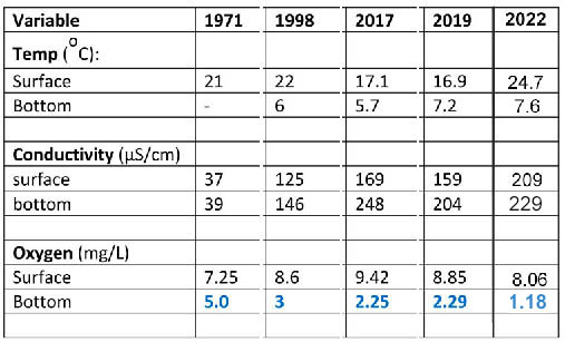
Table 1. Historic Shallow and Deep Water Temperature, EC and Oxygen values for Sandy Lake (Bedford) during the summer stratification period.
1971: from Metropolitan Area Planning Committee 1971-1972: Water Quality Survey for Selected Metropolitan Area Lakes. Lake sampled on Aug 30, 1971. Deep sample at 59 feet (18 m). Chloride was 8.0 at surface, 12.0 at 59 feet (18 m). EC and chloride were elevated in the Southern Inlet sample (57.0 µS/cm, 11.0 mg/L). 1998: Nova Scotia Lake Inventory Program Sep 2, 1998. Deep sample at 19 m. Chloride at surface was 29 mg/L at 19 m, 34 mg/L. 2017: Sampled Oct 3, deep sample at 17.5 m. 2019: Sampled Sep 30, Deep sample at 21 m. 2022 Sampled Aug 22. Two profiles, averaged the values (at 19,5 and 20m)
Although the data are limited, it’s clear that there have been big changes in deep water (bottom) dissolved oxygen and in conductivity (both top and bottom) over the 51 year period.

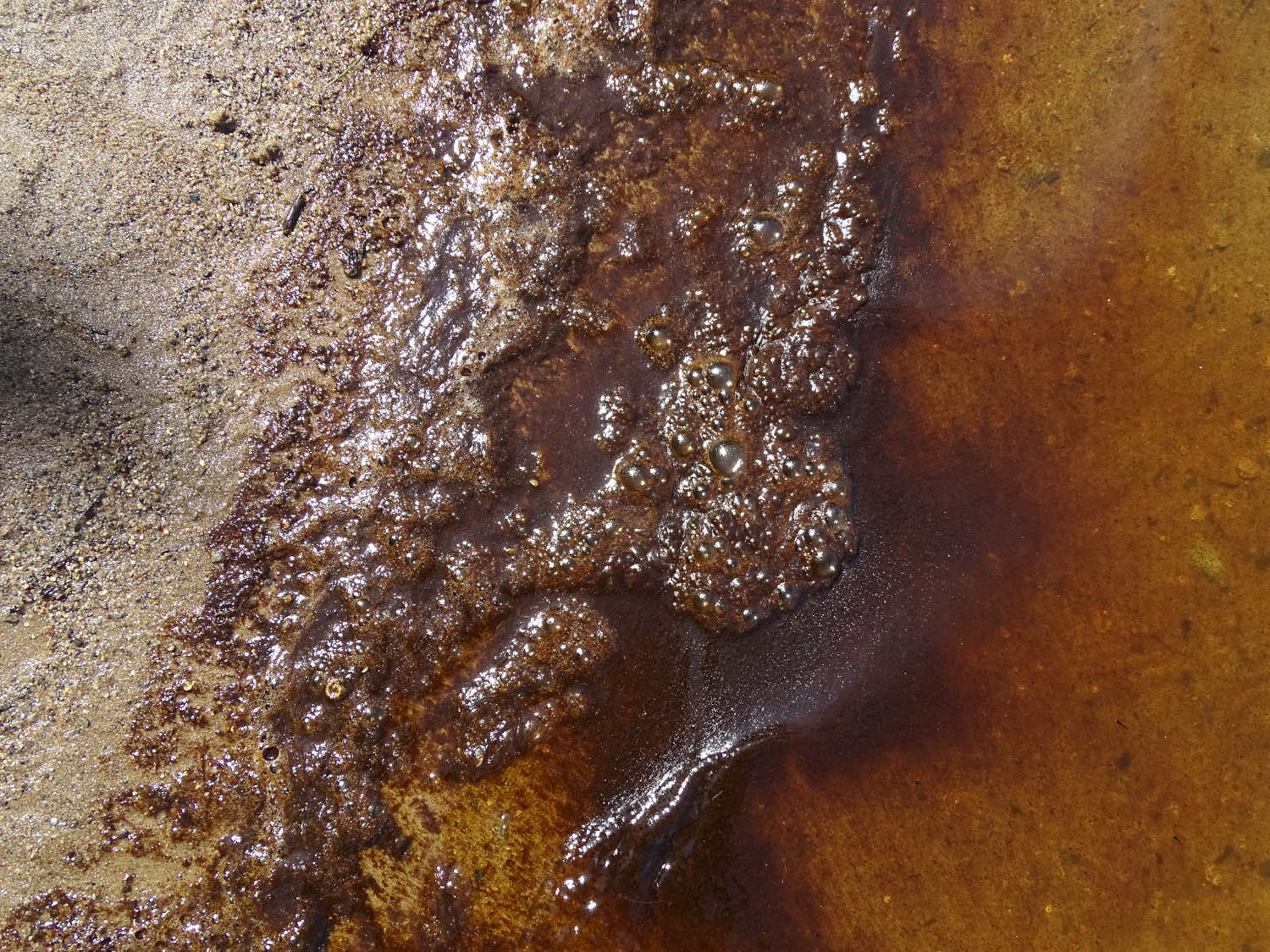
Sandy Lake Beach at 11:13 am on Aug 6, 2019. “an unpleasant, suspended, reddish, soapy material” appeared quite suddenly and the beach was closed.
Of particular concern is the progressive decline in bottom oxygen values over the 5 sampling dates, going from 5.o mg/L in 1979 to 1.18 mg/L in 2022. This has two major repercussions:
(i) Deterioration of the cool deep water refuge for salmonids in summer. 5.o mg/L oxygen is at best on the border line for brook trout and salmon (Doudoroff & Shumway, 1970, CCME 1999). (Salmon have been returning to the Sackville River Watershed including Sandy Lake through the efforts of the Sackville Rivers Association). Other species are also affected: “DO is considered an important measure of water quality as it is a direct indicator of an aquatic resource’s ability to support aquatic life…While each organism has its own DO tolerance range, generally, DO levels below 3 milligrams per liter (mg/L) are of concern and waters with levels below 1 mg/L are considered hypoxic and usually devoid of life.”- US EPA
(ii) There is increased likelihood that intervals of hypoxia (low oxygen) in deep water could result in anoxic conditions (no oxygen) at the sediment surface and associated mobilization of phosphorous, accelerating eutrophication and marked deterioration of water quality* e.g., due to blooms of BGA (Blue-Green Algae, or Cyanobacteria). Numberg (2004) states that “2 mg L–1 measured by a DO probe about 1 m above the sediment usually coincides with anoxic conditions at the sediment surfaces located at that depth.”* See the introductory paragraphs in Tammeorg et al., 2020 for an explanation.
The continuous decline in deep water oxygen over time with levels below 2 mg/L reached in 2022* should be alarming. If this trend continues, the lake could go fully eutrophic and ‘skunky’ in the not-very-distant future.
*See the limnological profiles: in 2022, oxygen levels at 16 m and deeper were all below 2 mg/L.
———–
UPDATE June 21, 2023: Two limnological profiles obtained in Sandy Lake by Casey Doucet in relation to her research for a Masters in Applied Science at Dalhousie University provide some independent verification of our observations. (View thesis on Dalspace). She sampled two sites on Sandy Lake in the latter half of August 2021, one at the deepest point or close to it; her max. depth sampled was approx 19 m; and a second site with max. depth sampled approx 5.5 m. At the 19 m site, the oxygen value for deepest sample was approx 0.41 mg/L; she also measured total P at 0, 3, 7 ,10 and approx 18 meters; values 0-10 m were close to 10 ug/L; the 18 m value was approx. 22 ug/L, i.e. there appears to have been significant internal P loading. Even at the shallower site, oxygen declined between 3 and 5.5 m from approx 8 mg/L down to close to 2 mg/L; and there was an overall increase in total P with depth.
———–
More observations e.g., as advised by Numberg (2004) would be required to determine the full extent of the “oxygen problem” in Sandy Lake. However, given that:
– already approved development in the watershed is ongoing (Bedford West Area 12),
– no special efforts have been implemented to reduce current phosphorus loading,
– elevated deep water P levels were noted by AECOM 2014 for two of three samplings in 2008, 2010 and 2011 and were suspected to be associated with low oxygen levels,
– increasing salt levels (mainly from de-icing road salt) coupled with salt stratification could at some point impede normal spring turnover, increasing oxygen deprivation (view Sandy Lake: Road Salts),
– an intense algal bloom occurred in 2019, and a BGA warning for the lake was issued in 2022*,
– climate warming is leading to increased harmful algae blooms globally (see e.g., Paerl et al., 2019, Ho and Michalak, 2019)
there is little reason to believe that a major new development, as modelled by AECOM 2014, could be compatible with maintaining – or re-establishing – desirable water quality of Sandy Lake.
___________
*UPDATE 17 June, 2023. At a meeting of the NorthWest Community Council on June 12, 2023 at which I made a presentation on “The Precarious State of Sandy Lake” and cited the 2019 algal bloom and the 2022 BGA Warning as above, Councillor Tim Outhit commented that tests by HRM in fact showed these events were attributable to pollen. In followup correspondence with Elizabeth Kennedy, Director of the Water Branch at the Nova Scotia Government and Elizabeth Montgomery, Water Resources Specialist for HRM it was clarified that the 2022 BGA warning issued by the province was based on a citizen report, not direct observation; and that testing of water at Sandy Lake beach in 2022 by HRM did not reveal presence of BGA, but there was pollen present; HRM testing indicated that the 2019 “algal bloom” was associated with diatoms (a type of algae), as I had assumed.
Clearly, if we value Sandy Lake and Marsh Lake downstream for their many ecological and recreational benefits, we need to take steps now to reduce organic, salt and phosphorus loading from developed areas of the watershed.
We should also retain as much as can of the remaining undeveloped lands in the Sandy lake Watershed in their current natural or near-natural state as envisaged in the 1970s, and promoted more recently by the Sandy Lake-Sackville River Regional Park Coalition.
2006 Regional Plan Note
The Final Draft of the 2006 Regional Plan is no longer available in full online. I did retain an electronic copy of the Regional Municipal Planning Strategy (downloaded at the time as a file lablleled “RMPS_FinalDraftApril06.pdf” Sandy Lake and Jacks Lake are cited as follows:
In CHAPTER 2 ENVIRONMENT, Section 2.1.3 Regional Parks (pages 24 & 25)
…The 1975 Halifax Dartmouth Regional Development Plan, repealed in 1998, contained policies and Regional Park designations supporting a Regional Parks and Trail System. The objectives were to preserve seven natural landscapes of outstanding value and to establish interconnected trail system between them. Over the years, the Province and former municipalities acquired lands to create the present Regional Park system. However, the full scope of the plan was not completed. This, coupled with future population growth contemplated at higher densities for urban and suburban areas, requires additional areas to be preserved for future Regional Park development.
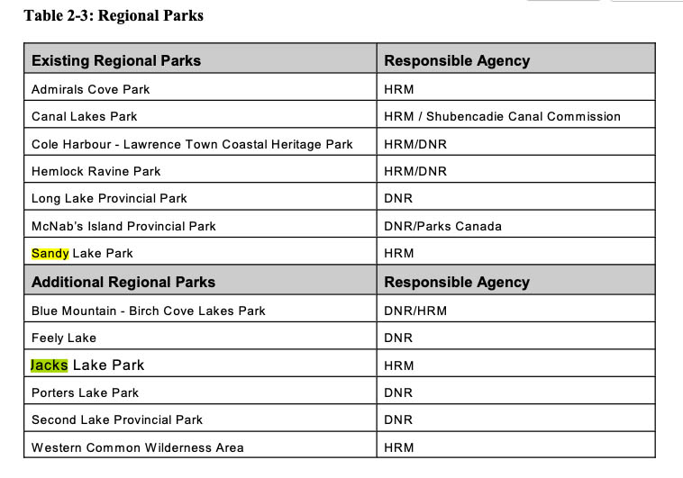
HRM intends to create additional Regional Parks at various locations throughout HRM including the Western Common, Blue Mountain – Birch Cove Lakes, Feely Lake, Jacks Lake, Second Lake, and Porters Lake. The existing and additional Regional Parks are identified in Table 2-3…
The Jacks Lake lands are under the ownership of HRM except for approximately 20 hectares (exact boundaries to be determined) in the ownership of the Province of Nova Scotia. HRM intends to carry out a study to determine the appropriate geographic boundaries of the Jacks Lake Park. Remainder lands, including the lands owned by the Province, should be re-designated for development as appropriate as determined through the secondary planning process for the Sandy Lake Urban Settlement area.
In CHAPTER 3: SETTLEMENT AND HOUSING Section 3.1 Urban Settlement Designation (p. 38)
———-
Evidently, “Sandy Lake Regional Park” cited in the 2006 Regional Plan refers to the “130 forested acres with frontage on Sandy Lake” included in the “Sandy lake Park” opened in 2004:
Evidently the “Jacks Lakes Park” identified in the 2006 Regional Plan refers to the ~1000 acres around Jack Lake that CHMC gave to the Province in 1986 and that was turned over to HRM in 1996 – see TIME LINE of SANDY LAKE – SACKVILLE RIVER (Marsh/Jack Lakes) Regional Park (on Sandy Lake Conservation Association website).
CORRESPONDENCE JUNE 12-14, 2023 RE: Clarification of “algal bloom” (2019) and “BGA warning” (2022)
In a presentation I made to the NW Community Council on June 12, 2023 on The Precarious State of Sandy Lake I referred to an algal bloom in 2019, and a BGA Warning in 2022 as cited above. Following the presentation, Councillor Tim Outhit (HRM District 16) commented that tests by HRM in fact showed these events were attributable to pollen. In followup correspondence with Elizabeth Kennedy, Director of the Water Branch at the Nova Scotia Government and Elizabeth Montgomery, Water Resources Specialist for HRM, copied below, it was clarified that the 2022 BGA warning issued by the province was based on a citizen report, not direct observation; and that testing of water at Sandy Lake beach in 2022 by HRM did not reveal presence of BGA, but there was pollen present; HRM testing indicated that the 2019 “algal bloom” was associated with diatoms (a type of algae) as I had understood at the time and that was consistent with my observations.
———-
From: Elizabeth Montgomery
Sent June 15, 2023 at 3:39 PM
To David Patriquin, cc Tim Outhit, others
…I can’t speak in specifics to the 2019 event past what you’ve outlined below. I did find photos from the same event in our files, and they are consistent with diatom populations I’ve seen.
…As for the June 2022 event, I can confirm that analysis was done at the Sandy Lake beach and no toxin-producing species of cyanobacteria were observed there – that did turn out to be pollen. There was a bloom reported in Sandy Lake to the province at the end of June (I believe this was the same bloom I looked at, but cannot say for sure). We are taking an active approach at our supervised beaches, and confirming toxin levels are within the Canadian Recreational Water Quality Guidelines threshold within the swimming area.
The province is not sampling and analyzing blooms reported to them by residents, so in those cases, unconfirmed means no one has confirmed what actually is present in the water. They have taken a risk management approach where they are looking to educate residents on the risks associated with cyanobacteria, and then allowing residents to determine their own risk tolerance, much like the response to ticks and Lyme disease.
————
From David Patriquin
Sent June 15, 2023 at 8:15 PM
To Elizabeth Montgomery
Hi Elizabeth, a followup question.. After I saw the CH report last summer, I did try to fund out more about it subsequently, mainly because I wanted to take my g’daugher swimming there.
As I recall, I couldn’t find anything on the HRM website about it and I called a cottage owner I know and asked if they knew anything about it, had they seen any BGA etc.
They said no, so then I took it as Ok to swim again.
Also as I recall, but my memory may not be accurate, I asked the lifeguards about it when we went to the beach in Aug, and they didn’t know anything about it.
So a question- was there any notice from HRM on their website about BGA at Sandy Lake last summer, ,either about its possible occurrence, and/or subsequently about not finding it.
‘Just trying to understand how I missed it.
Thx for any info,
Response from Elizabeth Montgomery June 20, 2023:
…The bloom that NSECC reported in Sandy Lake in 2022 was observed in late June. I went out and checked it because it was within a week of our beach season opening, and was able to confirm it wasn’t toxin-producing cyanobacteria. HRM wouldn’t have made any notice regarding this bloom, because we only monitor and issue notices at our supervised beaches during the time they are supervised, July 1 – August 31.
——–
From: David Patriquin
Sent June 13, 2023 at 8:30 AM
To: Tim Outhit, Elizabeth Montgomery
…There are 2 -emails and an additional Note (this e-mail) , most recent at the top. I asked Tim to forward the documentation for his comment that the 2019 “Algal Bloom” I referred to was in fact due to pollen, not algae; and that the 2022 report of BGA (blue-green algae) at Sandy Lake was not confirmed.
—————-
An additional Note: re: the “Algal Bloom” on Aug 6, 2019: There was very vigorous gas production, (see photo below, Aug 6, 2019; on the beach at Sandy lake), which in addition to the initial HRM report identifying diatoms as the agent, is another reason for thinking the scum was associated with algae, rather then pollen (pollen is non-photosynthetic, and decomposes very slowly).An additional odd feature about the event was that it coincided with a rapid drop in lake water level and dissipated rapidly which I have speculated was due to transient disruption of stratification (associated with removal of a beaver dam on Peverill’s Brook) and release of nutrients from deeper waters. See post http://versicolor.ca/sandylakebedford/2019/08/07/sandy-lake-inundated-by-unpleasant-suspended-reddish-soapy-material-aug-6-2019/.
————–
From: David Patriquin
Sent June 13, 2023 at 7:37 AM
To Tim OuthitTim, for reference: Here is the info you forwarded to me on Aug 8, 2019:
“We received the lab results late yesterday afternoon that the specimens identified in the lab were principally diatoms (a form of algae), with trace amounts of one species of cyanobacteria that does not produce any toxins. Correspondingly, staff (i.e., P&D Acting Director Eric Lucic) has approved lifting the PSA. Corporate Communications is now drafting that PSA…”I do not disagree that the material could have been pollen, but it really did not look like it, it was dark and biologically very active releasing gas etc. (Pollen decomposes more slowly). It did not have the typical yellowish colour and float like pollen which I have seen on lakes. It looked more like “algal scum” – meaning not BGA but produced by algae (BGA are not true algae) See for example pics here: https://www.gov.nl.ca/ecc/files/waterres-outreach-weird-weird-stuff-in-water.pdf
So I am wondering, was the conclusion that it was “pollen’ an opinion, or was it based on actual microscopic observation subsequent to that you forwarded to me on Aug 8.
In regard to the 2022 report, you said I believe “it was not confirmed” But do you mean that a citizen reported it, it was investigated and found not to be BGA; or do you mean it was not followed up and therefore not confirmed.
I appreciate your clarification.
————From: David Patriquin
Sent June 12, 2023 at 8:25 PM
To Tim Outhit, othersTim, thanks for the update on the algae, Can you send me the documentation, and I will post it on my website.
———–
From: David Patriquin
Sent: Wednesday, June 14, 2023 at 1:30 PM
To: Kennedy, Elizabeth C <Elizabeth.Kennedy@novascotia.ca>
Subject: On a report of BGA at Sandy Lake (Bedford) in 2022
There was a report in the Chronicle Herald on June 27 of last year that
“The province reported blue-green algae in:
– Sandy Lake in Bedford
– Stillwater Lake in Tantallon
– Coon Pond, in Upper Tantallon
– Stream inlet into Bissett Lake in at Colby Drive in Cole Harbour
– Just outside of HRM, Shubenacadie Grand Lake and Fish Lake near Enfield
Can you tell me was this an actual test/direct observation, or simply a report by someone (non-professional) of a possible occurrence of BGA at that site? Was there any further follow-up?
Thx for any info you can offer.
————
From: Kennedy, Elizabeth C <Elizabeth.Kennedy@novascotia.ca>
Sent: June 14, 2023 3:07 PM
To David Patriquin
We only inspect/confirm BGA reports that are in lakes that supply a public water supply. Looking at the list I don’t believe any of these are public water supplies.
For non drinking water, we do not inspect. We take the report from the public and identify it on the web as a report but we do not confirm. We alert recreational facilities located on or associated with the lake (guarded beaches, boat clubs, camps etc) of the report and they follow their own procedures for verification and management.
———–