
Notes for In Conclusion…
1. Some background to my involvement. I was a faculty member of the Biology Department at Dalhousie University 1973-2008, with specialization in coastal marine biology, plant and microbial ecology; since retirement I have been active in several natural history and trail organizations (more details here). In the late spring of 2017, I was asked by the Sandy Lake Conservation Association if I would do a “flora survey” of Sandy Lake and Environs for along the lines I had conducted on the Williams Lake Backlands in 2013/2014. I agreed and conducted field trips on 22 days over the period June 14 to Nov 1, 2017; a few were mostly on water (paddling), most were on land. It was a volunteer activity, there was no payment and no contract. As a component of that study and because I was familiar with limnological techniques and out of curiosity, on Oct 3, 2017 I conducted limnological observations at 3 points in Sandy Lake with the help of a local volunteer. The results raised some concerns. In the late fall of 2017, I realized that far more observations – and time – were needed to adequately describe “Sandy Lake & Environs” at large. So rather than submit a single final report, I would post observations and related info on a website – Sandy Lake & Environs (Bedford, Nova Scotia) – on an ongoing basis. The website was launched on Dec 20, 2017. I posted a “A DRAFT Report On the State of Sandy Lake, the Historical Trends and its Future Trajectory” on Feb 23, 2021 which integrated all limnological observations to that point, but observations have been continuing and are reported in the section Surface Waters and it subpages.
2. Detales in other pages:
2. The limnological profiles consist of measurements made with a Water Quality Multimeter of temperature, conductivity (a measure of salt content), oxygen and (sometimes) pH at 1 meter or shorter depth intervals. Beginning in August of 2022, we conducted our observations under the umbrella of the newly formed HRM LakeWatchers program, which allowed us to make the observations within more consistent time intervals – prior to that, the equipment was borrowed from community equipment banks and we could not always get it at the desired sampling times. Sandy Lake is one of 72 Lakes that had been “assessed as either highly vulnerable or moderately vulnerable through a previous study” and were selected initially to be included in the LakeWatchers Program. The Vulnerability Class for Sandy Lake was “Class A – High Vulnerability” and the Priority Concerns concerns were identified as “Eutrophication” and “Bacteria Contamination (Beaches)” – Table 9, p 53 in HRM Water Quality Monitoring Policy and Program Development (AECOM 2020) In addition to the Limnological profiles at the deepest spot in the lake, the observations include secchi disk (a measure of water transparency), top and near-bottom water samples analyzed for TP (Total Phosphorous, deep measurement in summer sampling only), chlorophyll-a (surface only) and chloride – 1 m off the bottom, summer sampling only; and Multimeter measurements of and a sample of surface water near the outlet. As Sandy lake is a “Class A — High Vulnerability Lake”. 2 sampling events per year are prescribed (Table 12, p 66)
– once in spring during mixed-water column conditions [our samplings have been in April whihc is at or following spring turnover of the water column]
– once at the end of summer [our sampling have been in the latter part of August which is close to the time of peak summer stratification]
Halifax Regional Municipality Water Quality Monitoring Policy and Program Development, Prepared by: AECOM Canada Ltd., September 2020, 99 pages + Appendices, 505 pages total. Also view Environment & Sustainability Standing Committee June 3, 2021 SUBJECT: Water Quality Monitoring Policy & Program Development (14 pages)
103. Casey Doucet; inlcude paper.
104 (Numberg (2004).
in actuality, Sandy Lake is exhibiting features characteristic of lakes in an upper mesotrophic to eutrophic state [107]
106 Access to AECOM, not on halifax.ca
99.Further, the deep water total P value was highly elevated (40 ug/L) indicating phosphorous mobilization at the sediment surface or occurrence “internal phosphorus loading”, also observed in 2021 and in some earlier years [99]
100. Spring Total P values in Oligotrophic to low Mesotrophic range: View (i) values of Spring Total P for Sandy Lake 1980 to 2021 in Synoptic snapshots: monitoring lake water quality over 4 decades in an urbanizing region, Supplemental Material by Doucet et al. 2023 in Lake and Reservoir Management; (ii) Values for Total P 1979-2014 in AECOM 2014, Fig 8, page 22 (spring values only) & Fig 9, page 24 (all values) (iii) Total P spring values, 2022 onward: Halifax LakeWatchers, view link to Lab Results.
110: See AECOM 2014, 9. Recommendations for Water Quality Monitoring, page 42
[201] Anoxia begets anoxia: A positive feedback to the deoxygenation of temperate lakes
https://onlinelibrary.wiley.com/doi/10.1111/gcb.17046
Lakeshore Capacity Assessment Handbook: Protecting Water Quality in Inland Lakes on Ontario’s Precambrian Shield Appendix C : Dorset Environmental Science Centre Technical Bulletins
Includes: Hypolimnetic Oxygen: Data Collection Strategies For Use In Predictive Models
chart in Supplemental Materials in
———-
Canadian Council of Ministers of the Environment. 2004. Canadian water quality guidelines for the protection of aquatic life:
Phosphorus: Canadian Guidance Framework for the Management of Freshwater Systems. In: Canadian environmental quality guidelines, 2004, Canadian Council of Ministers of the Environment, Winnipeg
https://www.alberta.ca/water-indicators-lake-trophic-status
https://www.ysi.com/ysi-blog/water-blogged-blog/2023/09/limnology-101-understanding-trophic-states?
210 p21 Total phosphorus in Table 3 ranged from 2 g/L to 43 g/L between 2006 and 2013 (Figure 8). The median concentration of total phosphorus is 12 g/L, which places the current water quality of Sandy Lake in the lower end of the mesotrophic range. This indicates the lake water quality is good and has moderate biological productivity.
p 41 8.3 Lakeshore Capacity Model Summary
In summary, the LCM predicts the Scenario 2 full build out of all planned developments in the Sandy Lake watershed will result in an increase in phosphorus concentrations to 16 μg/L in Sandy Lake and 15 μg/L in Marsh Lake (Table 13). Scenario 3 includes full development in the watershed but reduces phosphorus inputs by removing the Uplands WWTF and removing the septic systems within 300 m of Sandy Lake. The LCM predicts phosphorus concentrations in Scenario 3 to be 15 μg/L in Sandy Lake and 14 μg/L in Marsh Lake. Development in the Sandy Lake watershed will increase in phosphorus concentrations in lake water by 20 to 30 % from existing conditions, but will remain within the recommended water quality objectives for Sandy Lake and Marsh Lake.
7.1 Development of Total Phosphorus Water Quality Objectives (WQO)
For the Sandy Lake watershed AECOM recommends the use of Environment Canada’s trophic status classification to set WQOs for total phosphorus. As noted in section 1.2.1, an objective of the 2006 HRM Regional Plan is to “maintain the existing trophic status of our lakes and waterways”. This suggests that both Sandy and Marsh Lakes should be maintained in their current mesotrophic state and so the WQO for total phosphorus should be the upper limit of the mesotrophic range, or 20 g/L. However, since both lakes are currently at the lower end of the mesotrophic range, considerable water quality degradation could occur before the lakes were at risk of exceeding such a WQO.
Siltation barrier at Eisner Cove. Video posted Aug 18, 2022
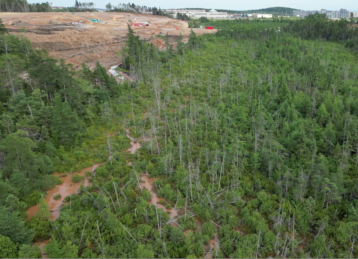
Siltation in Eisner Cove Wetland visible on July 24, 2023. View Video The uplands were clearcut by Clayton Developments earlier on; The LSA/EAs such as they were failed to recognize any connections between the upland and the fen (View comments). Photo & Video courtesy of Bill Zebedee/Protect Eisner Cove Wetland
Drone fottage Drone footage (Matt Chisholm) 23 March 2024
shows silt-laden waters
The Alternative: a SLSRRP for all people and all species, Place developments on already degraded lands.