
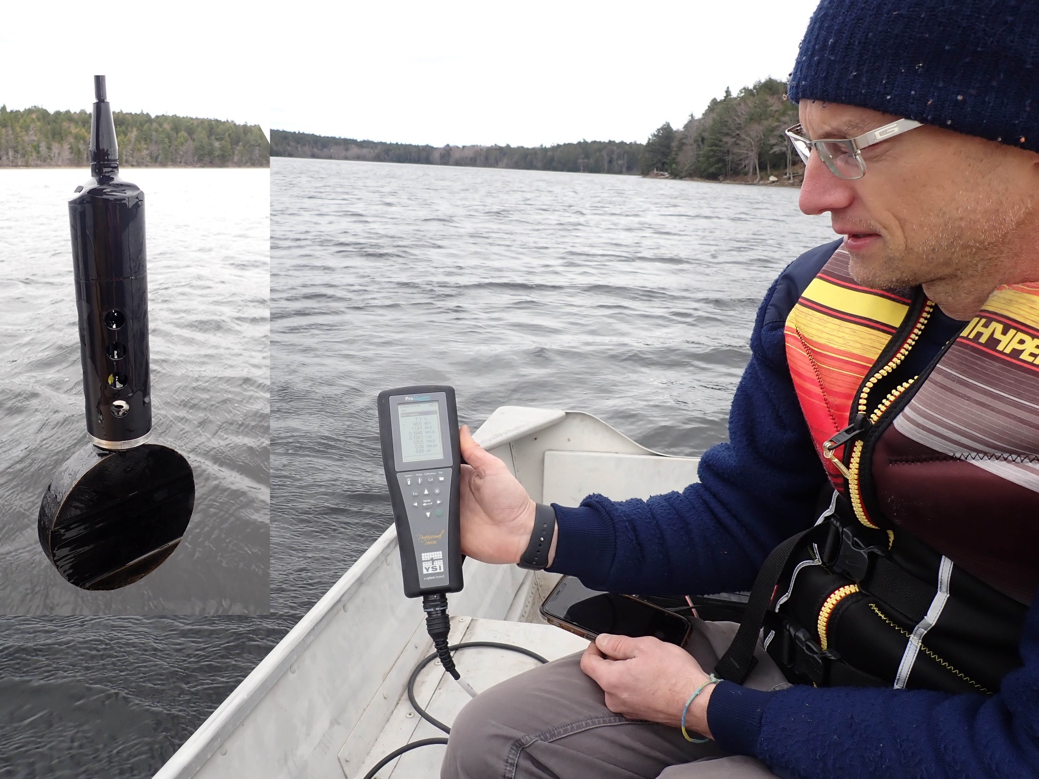
Volunteer Ed S with YSI instrument and probe on Sandy Lake
The latest limnological profile (Aug 12, 2024) confirms a long term trend of decline in the health of Sandy Lake (Bedford, NS); a major new development on its headwaters could do it in.
The evidence and rationale for this assertion is provided in detail in many separate pages on this website. This page provides a concise overview of the key facts and arguments.
by David Patriquin [1]
NAVIGATION
Where this page resides; related pages
www.versicolor.ca/sandylakebedford
Website for Sandy Lake & Environs (Bedford, Nova Scotia)
…Surface Waters
……Sandy Lake
………Limnological Profiles
…………2024 Limnological Profiles
……………Addendum 1: Trends in Conductivity/Salt Content
……………Addendum 2: On Wetlands
…………………On wetland Benefits (WESP)
……………In Conclusion (This Page)
…………………About AECOM 2014
…………………Footnotes
Some basic limnology:
– Lake Stratification
– Trophic States of Lakes
CONTENTS OF THIS PAGE
1. Introduction
2. AECOM 2014 Predictions
3. Post-2014 monitoring reveals significant Water Quality issues
4. A concerning anomaly: a Metalimnetic Oxygen Minimum
5. Water Quality Objectives of AECOM 2014 are not adequate to protect Sandy Lake
6. A major development on the headwaters of Sandy Lake is not compatible with reversing current trends
7. The Exceptional Option we have to Save Sandy Lake
– Postscript
– FootNotes (separate page)
1. Introduction
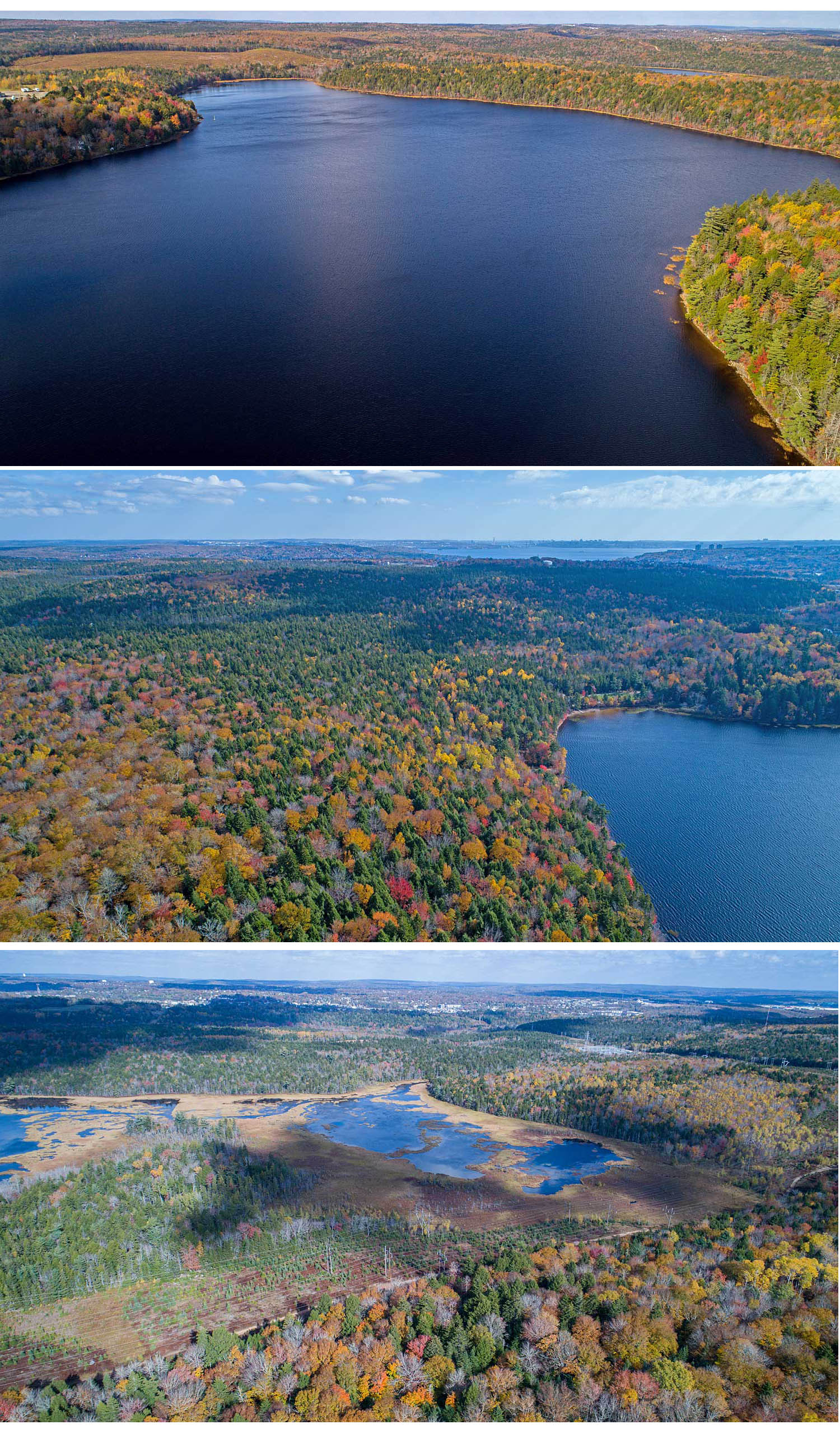
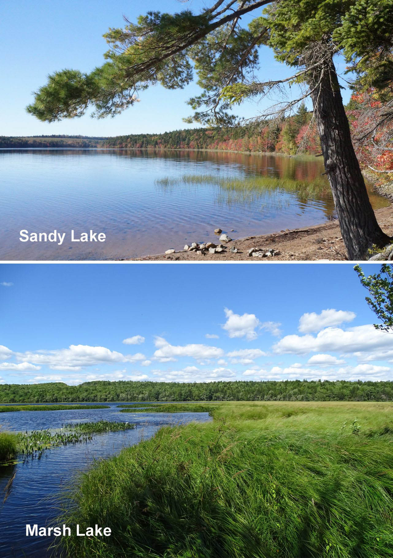
Great swaths of mixed Wabanaki/Acadian forest by Sandy Lake; bottom, Marsh Lake View more aerial vistas.
Click on images for larger versions
Sandy Lake is the diamond in a remarkable piece of land sandwiched between four growth areas (Lower and Middle Sackville-Bedford-Hammonds Plains-Lucasville Road) just NW of Bedford and the top of the Bedford Basin. The Sandy Lake watershed is the largest or second largest sub-watershed of the Sackville River Watershed, depending on how the sub-sub-watersheds are aggregated. That’s the watershed, Sandy Lake included, where salmon are coming back thanks to the efforts of the Sackville Rivers Association and its many supporters.
The large, still undeveloped area includes a wildlife corridor, now mostly a “stepping stone” but still critical for movement of wildlife/genetic transfer (plants included) between the Chebucto Peninsula and the greater Nova Scotia Mainland. It supports great swaths of Wabanaki/Acadian forest, most of it old forest with many pockets of Old Growth; there are even bear in the forests by the Sackville River. Marsh Lake, downstream from Sandy Lake is a “Treasured Wetland”. Thirteen Species-at-Risk make use of this landscape. [2]
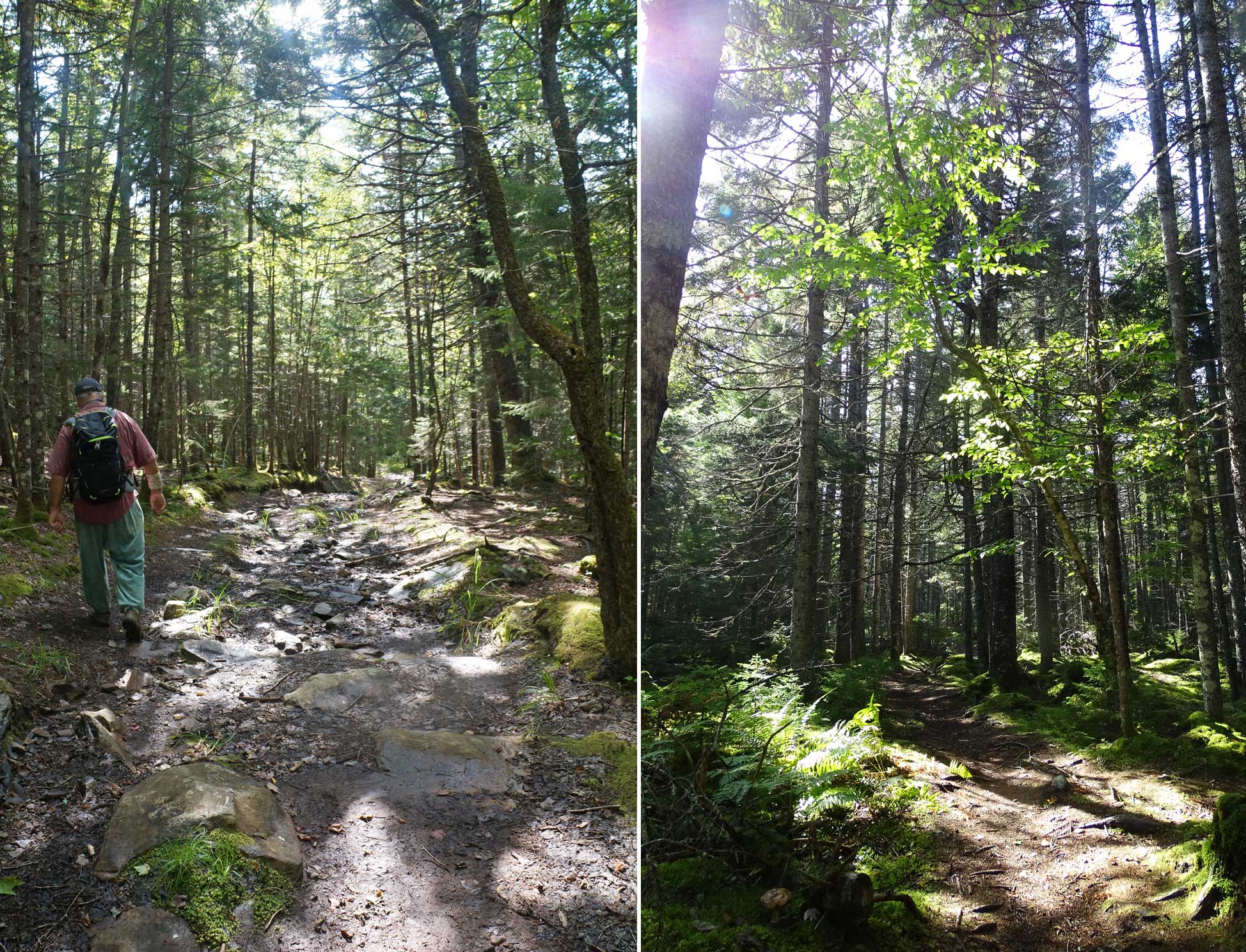
Left: old logging road
Right: Informal trail
The landscape is riddled with old logging roads and foot trails, enjoyed in all seasons by many but with a potential to serve many more. Sandy Lake Beach Park, founded by the Bedford Lions Club and now managed by HRM, is a magnificent, family oriented facility with a long shallow area safe for swimming, kids walk the beaches by adjacent wetlands fascinated by the tadpoles and frogs, others catch fish and paddle. Through all seasons, dog walkers frequent a trail/old logging road that skirts Sandy Lake Beach Park.
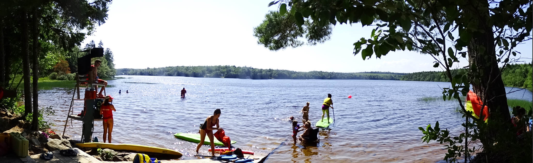
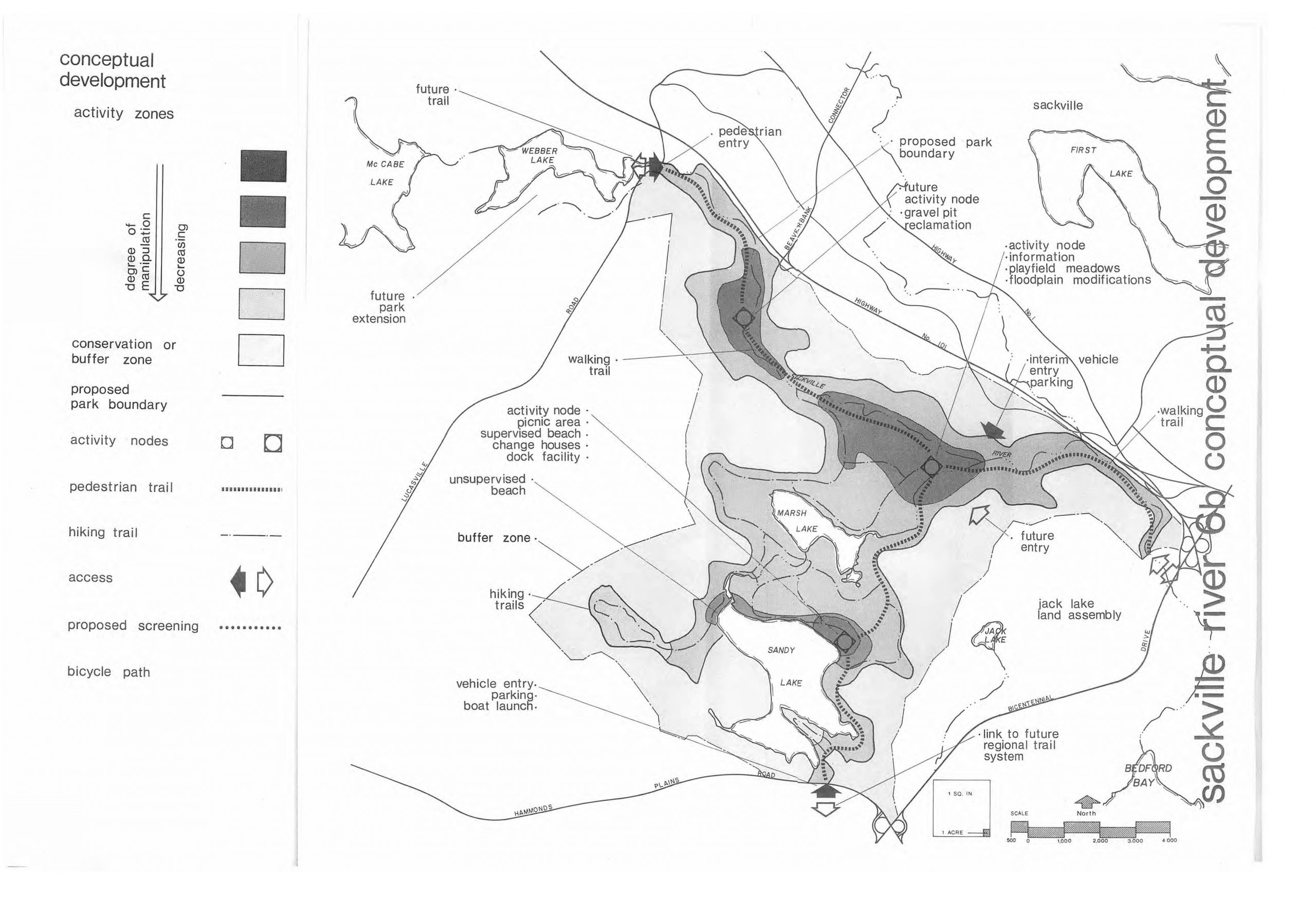
Fig. 1 Sackville River Regional Park as envisaged in a 1979 report. (Click on image for a larger version ).View 1979 Report. View website for the Sandy Lake – Sackville River Regional Park Coalition for the current vision of this park.
A Sandy Lake-Sackville River Regional Park, envisaged in some form or another since 1971, would provide a magnificent natural park/recreational area for the surrounding communities, conserve the biodiversity and the local and regional wildlife corridors and most importantly, the health of Sandy Lake and the downstream waters all the way to the Sackville River and thence to its mouth on the Bedford basin.
The many ecosystem services the area currently provides and the current and much greater potential social and recreational services would be severely reduced if the proposed major development to the west/southwest of Sandy Lake [3] goes ahead, none more so than the health of Sandy Lake itself. Below, I outline the basis for that assertion, detailed in other pages on this website [4].
To reduce clutter, I am minimizing the in-line links, and placing footnotes with explanatory details, critical references etc. on a separate page. Clicking on the reference to a footnote [#Footnote] takes the reader to the particular item on the footnote page.
___________
2. AECOM 2014 Predictions
The question of how a major development to the west/southwest of Sandy Lake could affect Sandy Lake was first addressed in “AECOM 2014 “, short for:
Halifax Regional Municipality Sandy Lake Watershed Study Final Report
Prepared by AECOM Canada Ltd., submitted August 25, 2014. 64 pages + Appendices (66 pages).“This body of work represents our current understanding of the environmental conditions in the watershed with a focus on lake water quality. The application of a phosphorus load model (Lake Capacity Model) provides a numerical narrative of how development may impact water quality. We identify several methods that can be utilized to mitigate water quality impacts.”
 Except for a few samples of lake water, AECOM 2014 was entirely a desktop study (as requested by HRM). See About AECOM 2014 (a page on this website) for more about the study.
AECOM 2014 concluded from their modelling that residential development in the watershed as proposed at the time would be compatible with maintenance of acceptable Water Quality in Sandy Lake if certain mitigation measures were implemented.
However, AECOM 2014 also recognized that “the degree of influence of urbanization on water quality in Sandy Lake can only be approximated using the phosphorus load model because of limitations arising from assumptions and uncertainty in the application of the model”. They proposed a water quality monitoring plan for the Sandy Lake in order to “provide a further assessment of current conditions and to evaluate the impacts of development on the water quality.”
Such a plan was NOT implemented following acceptance of the AECOM 2014 Report.
3. Post-2014 monitoring reveals significant Water Quality issues
Beginning in 2017, I worked with two volunteers from the Sandy Lake Conservation Association, Ed G and Derek S, to obtain limnological profiles in the deepest area of Sandy Lake during the latter end of the summer stratification period in 2017, 2019, 2022, 2023 and 2024 and during the mixing period that follows spring turnover in 2022, 2023, 2024 [5].
Independently, Casey Doucet obtained limnological profiles from Sandy Lake in 2021 in conjunction with her research for a Masters of Applied Science degree at Dalhosuie University [6]. Her observations are entirely comparable and complementary to ours, and provide some independent validation of our observations.
In a report on February of 2021 [7], I listed 4 major concerns about the state of Sandy Lake based on information gathered or made available after the AECOM 2014 report. The most immediate concern was “Low oxygen in deep water” about which I commented:
Our observations in 2017 and 2019 illustrate that deep-water oxygen levels were approximately half of the value observed in 1971 and were below levels required by salmonids. This difference is consistent with the lake having moved from an oligotrophic state to a mesotrophic state, and raises concern that the elevated deep water Total P levels noted by AECOM (2014) for two of three samplings in 2008, 2010 and 2011 is likely recurring and thus speeding eutrophication.
Subsequent observations further underscore that concern: in 3 of the 4 years (including 2024) in which late summer sampling was conducted after 2019, deep water (1 m from the bottom) oxygen levels were roughly half of those in 2017 and 2019 and well below 2 mg/L which is the approximate threshold value for occurrence of anoxic (lack of oxygen) conditions at the sediment surface [8].
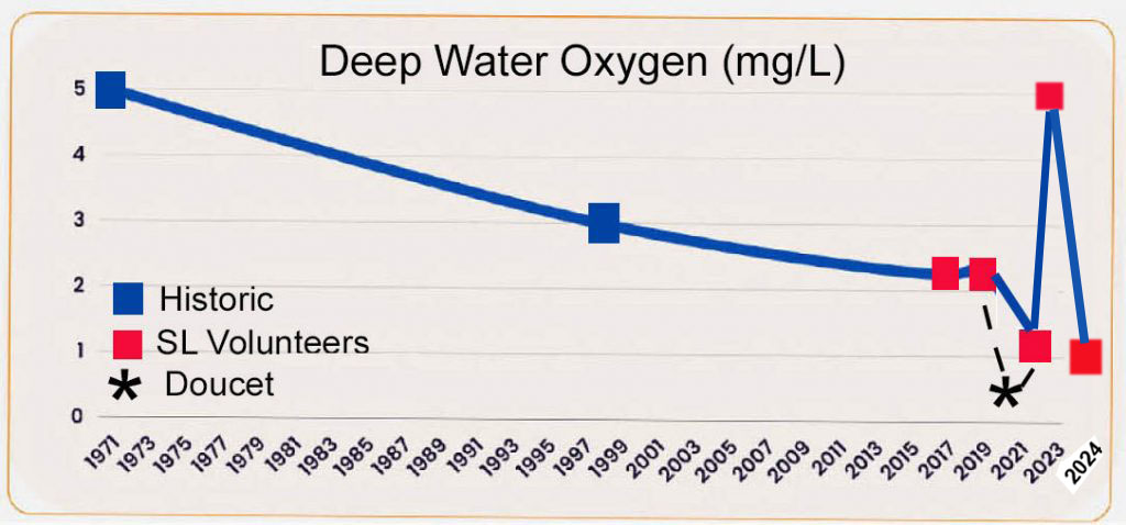
Fig. 2 Deep water oxygen levels at Sandy Lake 1971-2024. A continuous trend of decline in deep water* oxygen was interrupted in 2023, apparently due to flushing (turnover) of the lake brought on by heavy rains in Aug 2023. *“Deep water” is 1 meter off the bottom at the deepest spot in the lake which is circa 20-21 m depth
The 2023 value was highly anomalous and was close to the 5 mg/L observed in 1971; the conductivity values in 2023 were also anomalous and suggest that the extreme precipitation in the summer of 2023 essentially flushed the lake and re-aerated the deeper waters[9]. The phenomenon was not repeated in 2024 when we had more close-to-normal rainfall and the deep water oxygen was again very low. Further, the deep water total P value in August of 2024 was highly elevated (40 ug/L), indicating occurrence of “internal phosphorus loading”, also observed in 2021 and in some earlier years [10]; this phenomenon can accelerate deterioration of the lake [11].
4. A concerning anomaly: a Metalimnetic Oxygen Minimum
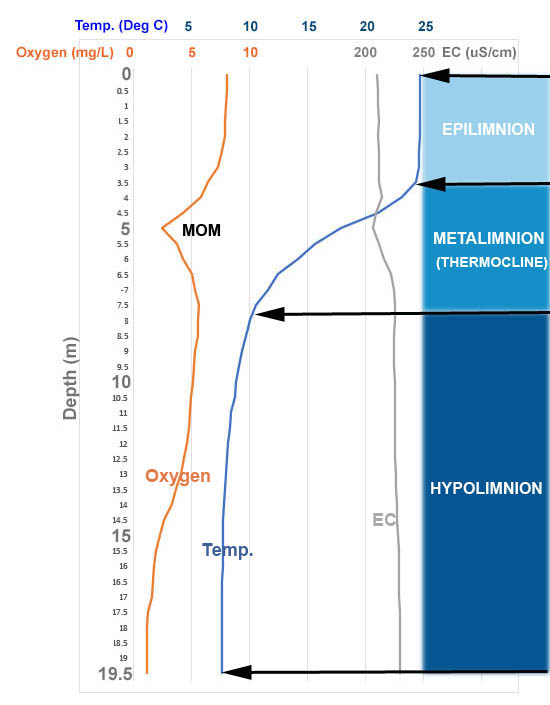
Fig. 3 Limnological profile in deepest area of Sandy Lake on Aug 22, 2022. “MOM”: Metalimnetic Oxygen Minimum.” EC: Electrical Conductivity
In addition to the decline in deep water oxygen, since 2021, we have observed an odd phenomenon in the late summer sampling, a “Metalimnion oxygen Minimum”. I first observed it in the August 2022 sampling: a dip in the oxygen to 2.4 ug/L centering at 5 m depth in the zone of sharp change in temperature (the Metalimnion or Thermocline). I was skeptical about its reality as the oxygen readings were taking too much time, I felt, to equilibrate; I wrote a note to the organization from which we had borrowed the equipment to suggest that perhaps the sensor membrane needed to be replaced.
In the late fall of 2022, Casey Doucet reported on limnological observations she had conducted on a suite of lakes in HRM, including Sandy Lake, in 2021, for her Masters of Applied Science research at Dalhousie University [6]. Her plot of oxygen versus depth for Sandy Lake in mid August 2021 showed almost exactly the same thing: a dip in oxygen to approx. 3.2 mg/L at 6 meters, in the metalimnion [12].
So I knew this dip was real. Then we observed the dip again in Aug 2023 and again in 2024 – 4 years in a row altogether (2021, 2022, 2023, 2024). [13].
I checked my “bible” on lakes – Wetzels Limnology, 3rd ed. (2001). It turns out that increases in oxygen in the metalimnion or “Metalimnetic Oxygen Maxima” are relatively common, dips in oxygen or “Metalimnetic Oxygen Minima” much less so. It appears they have not been previously reported to occur in NS lakes [14].
The precise cause of Metalimnetic Oxygen Minima may vary; they are more commonly observed in eutrophic (nutrient rich) lakes than in oligotrophic (nutrient-poor) lakes*. Interestingly, of the 4 lake profiles presented by Doucet 2022 [6] that were 15 m depth and greater, distinct dips in the metalimnion were present in the two (one of them Sandy Lake) that also exhibited very low oxygen and highly elevated total P levels near the bottom.
Metalimnetic Oxygen Minima in 2021 (Casey Doucet), 2022, 2023 and 2024 (our observations) were below 5 mg/L, and thus represent significant deterioration in the Water Quality of Sandy Lake for both both warm water and cold water aquatic life [15] beyond that associated with low deep water (hypolimnion) oxygen. Because Metalimnetic Oxygen Minima are usually associated in some way or another with enhanced respiration in shallower waters, they may also accelerate nutrient cycling and production in the upper waters (i.e. speed eutrophication)[16].
5. Water Quality Objectives of AECOM 2014 are not adequate to protect Sandy Lake
The trophic status of Sandy lake predicted by spring Total P values is in the oligotrophic to lower mesotrophic state [17]. However, the post 2014 observations of low oxygen levels in shallow (re Metalimnetic Oxygen Minimum) and deep (hypolimnion) waters, and evidence for internal phosphorous loading indicate that, regardless of the spring Total P values, in actuality Sandy Lake is exhibiting some critical features characteristic of lakes in more advanced trophic states [18].
In other words, our monitoring, combined with those of Doucet 2022, provide at least some of the “further assessment of current conditions” called for by AECOM 2014 [19] and the results clearly do NOT support the predictions and assumptions of the Lake Capacity Modelling conducted by AECOM 2014. In particular, the monitoring calls into question the AECOM 2014 assumptions or inferences based on Total P values alone, that (i) current lake water quality is “good” & (ii) the WQO (Water Quality Objective) for total phosphorus should be the upper limit of the mesotrophic range, or 20 ug/L [20].
In fact, the recent (2017-2024) observations combined with the historical data demonstrate that Sandy Lake has been on a downward trajectory since at least 1998 and is currently in a highly precarious state, the relatively low spring Total P values notwithstanding and let alone any consideration of significant new development within the watershed.
From a limnological perspective, the apparent contradiction between the trophic state based on Total P values (AECOM 2014) and the state of the lake based on the oxygen profiles and deep water P levels (Observations subsequent to AECOM 2014) is not unexepected in shallower and smaller lakes [21]. Deep water anoxia is becoming more common with climate warming [22], and could be further exacerbated by Internal Phosphorous Loading [11]. That does not make the Sandy Lake in its current state ‘normal’ and a condition we must accept, rather it behooves us to be even more stringent in our efforts to protect our lakes – and in the case of Sandy Lake, to take steps to reverse current trends now.
6. A major development on the headwaters of Sandy Lake is not compatible with reversing current trends
The precarious state of Sandy Lake currently, the increasing stresses on Sandy Lake anticipated with climate warming, and stresses that will accrue as already approved development in Sub-area 12 (Bedford West) proceeds, are factors that must be taken into account in any future assessments of the suitability of undeveloped lands in the Sandy Lake watershed for future development.
There is an additional, major factor at play that makes the currently proposed development – to the extent it has been described – even more of a threat to the health of Sandy Lake: it would be placed in an area of concentration of headwater watercourses and associated wetlands for Sandy Lake:
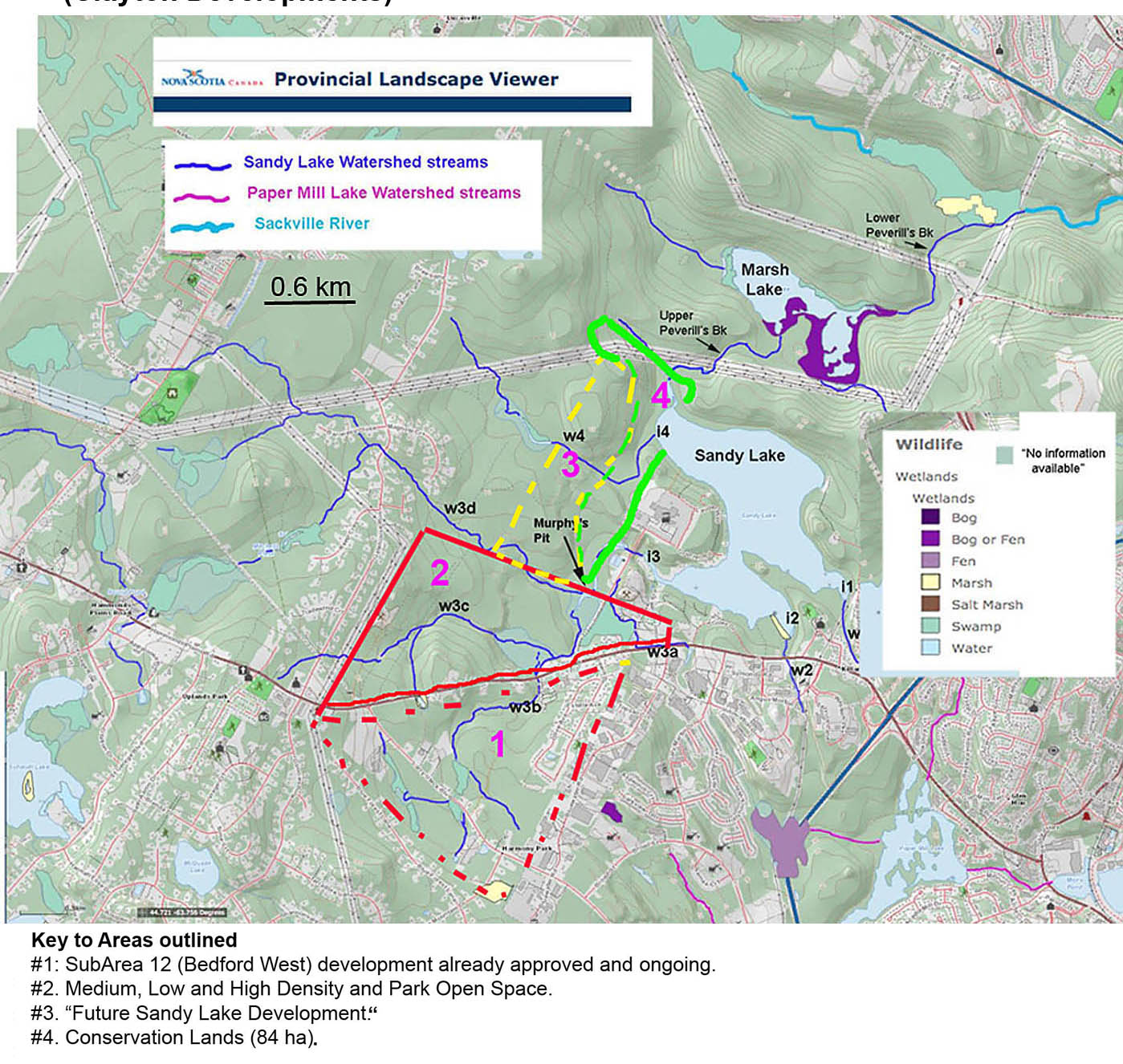
Fig 4 NS Provincial Landscape Viewer map with rough overlay of Sandy Lake Holdings (Clayton Developments) plans for development within Sandy Lake watershed as indicated in Fig 9 in Document C030 – Sandy Lake, Request [to HRM] by Sandy Lake Holdings (Clayton Developments) for a new serviced mixed-use (residential/ commercial) community, dated 2021[23]. Note that most of the watercourses in the area to be developed converge in the area of Murphy’s Pit and then enter Sandy Lake at its SW corner. View the Draft LSA page 5 for a map showing the wetlands more clearly.
View of Murphy’s Pit area from road looking south. Several streams converge in this area; open water is bordered by marshes and some of the forest is likely wet riparian forest. This area is important habitat and local migration corridor for snapping turtles. Photo Aug 20, 2020. View Murphy’s Pit Convergence for more photos.
Click on images for larger versions.
In 2020 I made an estimate of the proportion of water going into Sandy Lake that comes from settled landscapes, versus water coming from intact (unsettled) landscapes based on my measurements of the EC (salt) values for lake water, surface waters coming from settled areas, and surface waters coming from intact (unsettled) landscapes [24]. My estimate: 78% comes from settled areas, those mostly to the west and southwest of Sandy Lake; and 22% comes from currently intact landscapes. This conclusion is consistent with the comment in AECOM 2014: “The greatest flow into Sandy Lake is from Bobs Brook and other tributaries from the western portion of the watershed”[25].
Further, because the new developments would be placed towards the lower end of those watercourses, i.e close to Sandy Lake, the length and area of downstream watercourses and wetlands that might remove some of the sediment and phosphorous generated in the new developments is very reduced.
Most concerning is the possibility that the wide watercourse and wetland buffers as advised in the Sandy Lake Ecological Features Assessment (June 27, 2022) and recommended unanimously by HRM Regional Council [26] will not be recommended if a significant development is given the go-ahead and some wetlands may even be removed – at least that is what I have to conclude from the Draft LSA.
In the Draft LSA [27], the consultants identified 24 wetlands within their Sandy Lake Study Area, total area 48.6 ha. They conducted WESP Assessments on 13 of the 24 wetlands, their studies limited by “Multiple extreme weather events throughout the 2023 field season (i.e., wildfires and floods” and because field observations reveled many more wetlands than anticipated from desktop studies.”
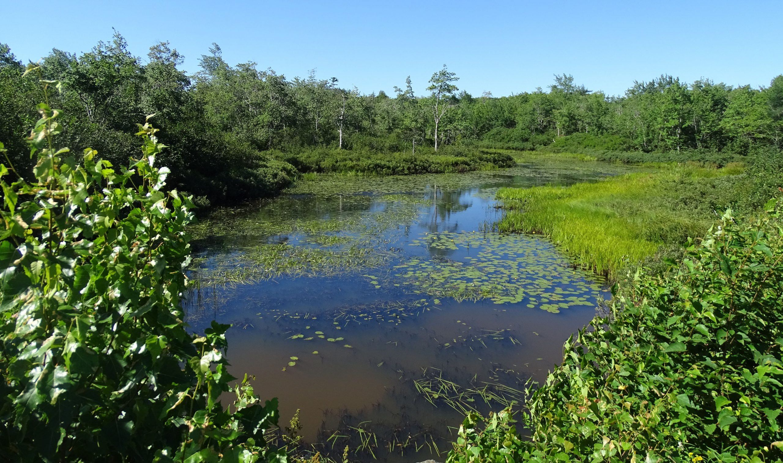
I have visited most of these wetlands [28]. There are wetland fringes along much of the lengths of watercourses leading into Sandy Lake and some large expanses of wetlands that drain into these watercourse which are flooded during high precipitation periods and events.
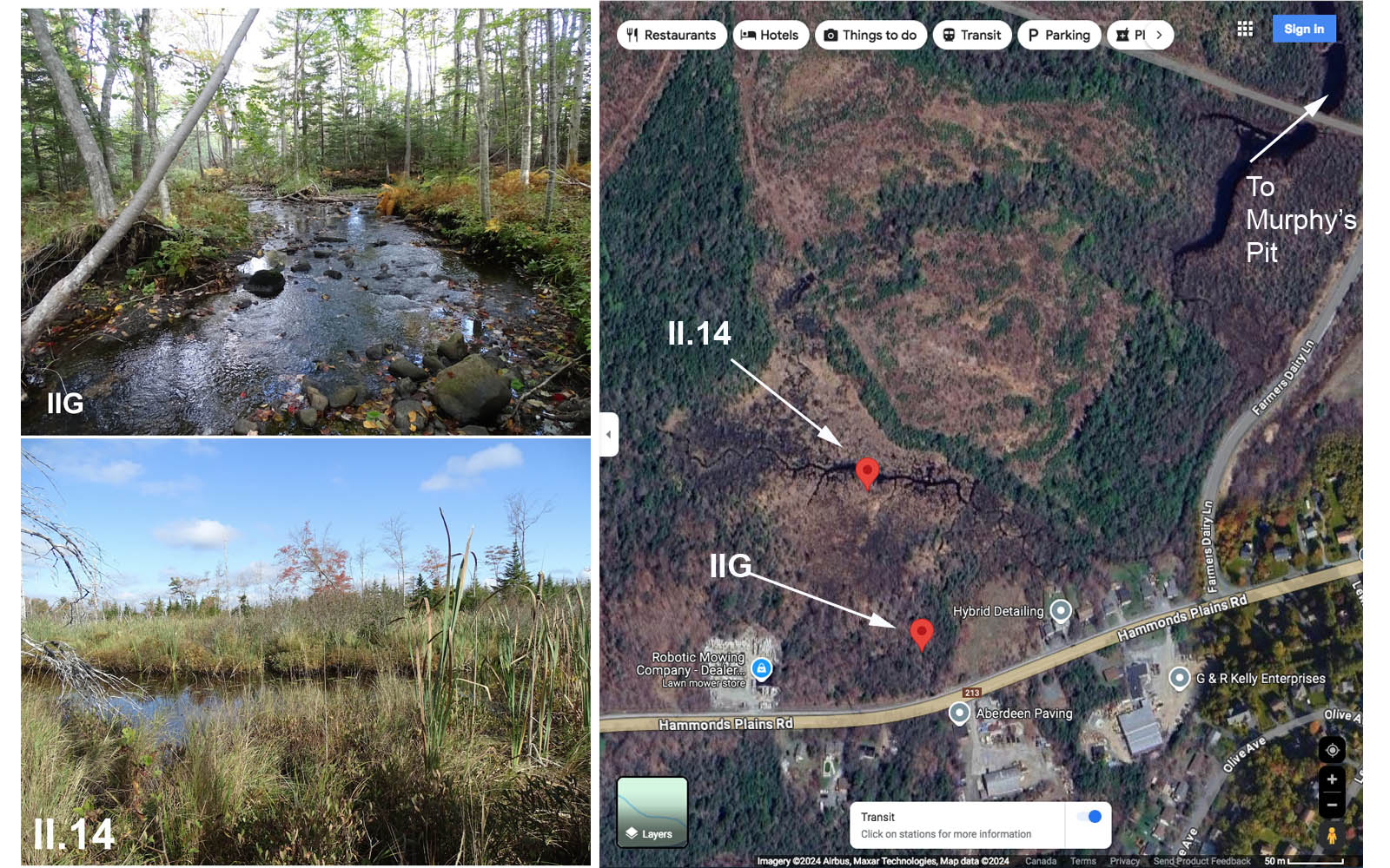
Examples of substantive wetlands within the area of proposed development. IIG: Stream coming from below Hammonds Plains Road (subArea 12) flowing north; extensive riparian forest occurs to the left in photo, and looking towards the left/NW, the landscape opens up into a large, open wetland. II.14: On the bank of a stream to the northwest of photo II.14, the stream flows west to east and eventually into Sandy Lake. We (myself and volunteer) could walk right up to it, but sunk up to our waists more than once. This area holds a lot of water and sediment. These wetlands lie within the large block of wetlands identified as SL5 in the Draft LSA: “Mixedwood Treed Swamp, Graminoid Freshwater Marsh, Tall Shrub Swamp/Approximate Wetland Area (ha): 23.06/Evaluated using WESP-AC: Yes/WSS: No/Ecological Condition Ranking: Moderate” – from pages 5,6 and 8 in the Draft LSA. View Photo Albums W and SW of S. Lake Part II [28] for more photos.
Remarkably this benefit was not considered in AECOM 2014 even though there was a large unidentified sink for phosphorous in their budgeting for the Lake Capacity Model [31].
Nor is removal of sediment and phosphorous by wetlands cited as a “Benefit” in the application of the WESP assessments to wetlands in the Sandy Lake Study Area in the Draft LSA released earlier this year.
Likewise, there is no Benefit Score for Water Storage by wetlands in the Draft LSA ; that’s a remarkable error, oversight, or deliberate omission, given the recent history of flooding in the Sackville River watershed. As I commented in Addendum 2: Wetlands [32], “The Sackville River Floodplain area, subject to repeated and severe flooding in recent years … lies well within the 5 km distance [of areas where buildings or infrastructure downriver or downslope from the wetland have been damaged or are in a mapped floodplain]. So on that basis alone, it could be expected that a Water Storage Benefits Score for the WESP-rated wetlands – were it reported – would be high.”
In fact no “Benefit Scores”, a normal output of WESP assessments and normally applied when WESP scores are used to assess WSS status, are given for any of the wetland functions cited in the Draft LSA . It’s a remarkable omission, made without any explanation [33] and clearly has to be addressed.
Two questions need to be answered:
1. Could the potential negative impacts of pre-construction & construction phases on watercourses and wetlands be ameliorated/prevented/reduced to a level that would not impact WQ of Sandy Lake? It simply seems very unlikely given
(i) The precarious state of the lake now – any increase in phosphorus loading, loading of oxygen-consuming organics, and of fine sediment would worsen the current condition. Particularly worrisome is the possibility or even likelihood that a positive feedback loop between phosphorous loading and hypolimnion anoxia [11] is already at play, thereby magnifying the negative effects of even small increases in phosphorus inputs, or intensification of other processes that increase oxygen consumption in deeper waters.
(ii) Observations of increased sediment loading on surface waters associated with pre-construction site preparation even when “Best Management Practices” are applied – e.g. at the Eisner Cove wetland site [34] .
2. Could the long term benefits lost due to removal of wetlands be compensated for by artificial swales, constructed wetlands etc.? A major constraint in this regard is the very limited area downstream from the locations of the proposed development, i.e between the development and Sandy Lake itself. Also, depending on how efficient the existing natural wetlands are in removing phosphorous and sediments and how any CWs (constructed wetlands) installed to compensate for losses of or degradation of the existing wetlands are constructed and maintained, they could be less efficient than the natural wetlands; I think we lack much of the information we would need to make confident predictions in this regard [35]. Wetlands do not remove salts, which would increase with development and cause further degradation in lake health [36].
Under the NS Wetland Policy [37], objective #1 is “To manage human activity in or near wetlands, with the goal of no loss in Wetlands of Special Significance and the goal of preventing net loss in area and function for other wetlands.” No wetlands were rated WSS in the Draft LSA. Related to Wetland Policy Objective #1 and “the goal of preventing net loss in area and function for other wetlands”: there is no discussion in the Draft LSA of how that might apply if wetlands at Sandy Lake are significantly altered, which it appears they will be, i.e. whether any compensatory wetlands be placed in the same landscape or elsewhere [38].
7. The Exceptional Option we have to Save Sandy Lake
Section 9 (p 42) in AECOM (2014) provided specific recommendations for robust Water Quality Monitoring. Such monitoring was not subsequently pursued by HRM, but now we have sufficient data from the volunteer observations (2017-2024) validated and augmented by those of Doucet (2022) to indicate that a Water Quality Objective in the mid-mesotrophic range (AECOM 2014) will not protect Sandy Lake.
Indeed, the observations illustrate that Sandy Lake is in a precarious condition now.
That’s not exceptional, especially given that Sandy Lake is a relatively shallow lake which makes it more susceptible than lakes deeper lakes or lakes with a more extensive hypolimnion to trophic degradation; and given trends of declining hypolimnion oxygen levels in temperate lakes associated with climate warming – in fact a climate warming signal for Sandy lake was identified from paleolimnological studies early in 2015 [39].
What is exceptional is that at this time Sandy Lake watershed is still not highly developed, and that there is still a possibility of limiting the biggest threat to the future of Sandy Lake: a major new development in the area of most of the headwaters and their associated wetlands as being currently considered.
An unpleasant algal bloom in Sandy lake in early August of 2019 was an “early warning sign” that the lake is in a precarious state [40] .
If we truly value Sandy Lake for the ecological and recreational qualities the area provides in the midst of a rapidly urbanizing landscape and not just pay lip service to them, we must (i) make efforts to ameliorate the current state of the lake and (ii) show such steps to be effective before any major new development in its watershed should even be – if ever – considered.
Surely for the sake of Sandy Lake remaining a precious recreational and ecological asset within a ‘Growth Landscape’, we can place the currently proposed development on some of the already ecologically degraded lands in the same general area, and take the steps needed to finally realize a Sandy Lake – Sackville River Regional Park.
By doing so we would be helping to address both the Housing Crisis and the combined Climate/Biodiversity Crisis simultaneously; and conserving a significant natural heritage/outdoor recreational area for the benefit of very many folks in the future.
That’s whats called for in 2024.
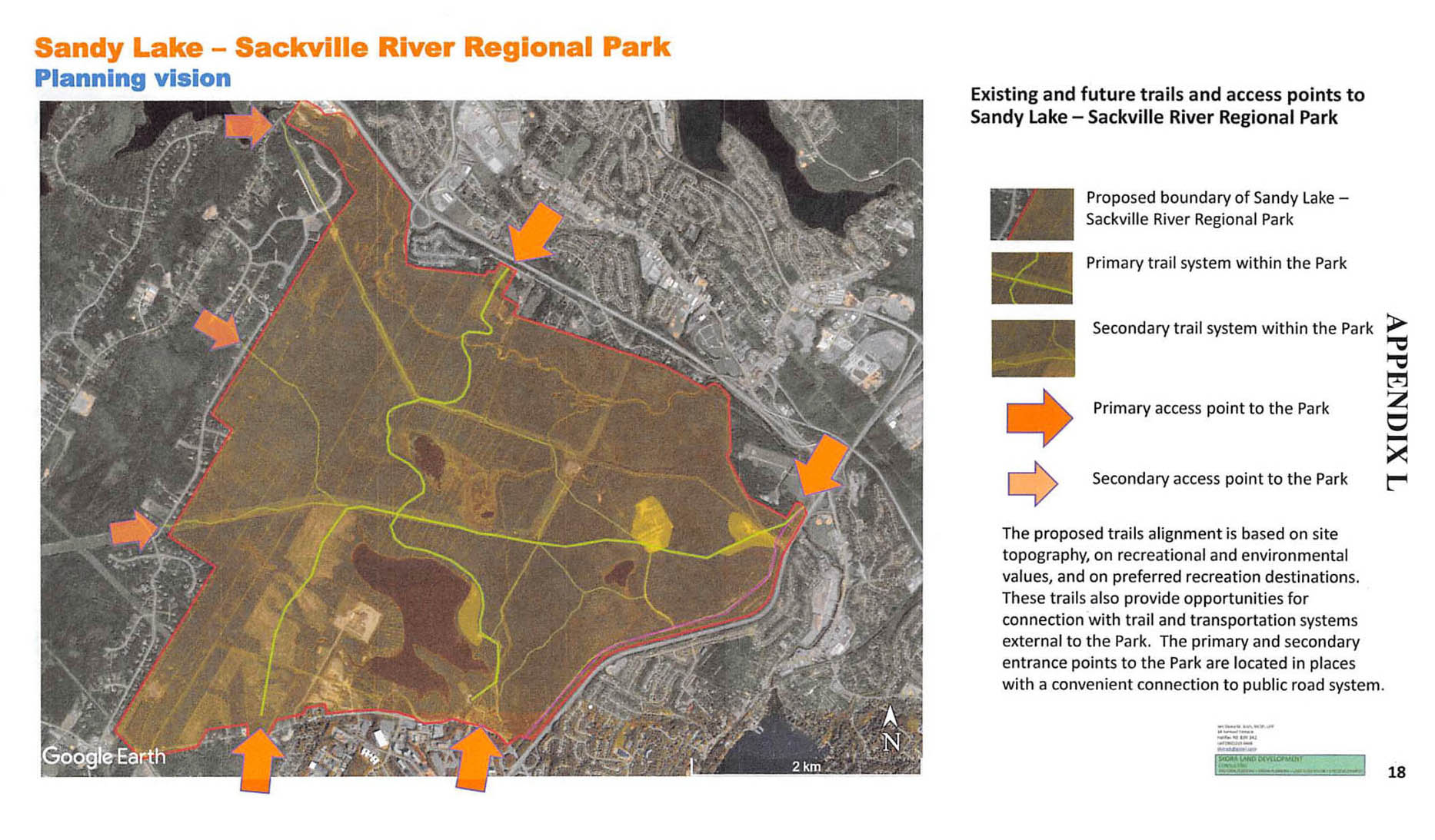
Fig 5. The proposed Sandy Lake – Sackville River Regional Park lies between growth areas on all sides. What a precious gift to future generations that would be. Map from Appendix L in the RP+10 Submissions (2020) from the Sandy Lake – Sackville River Regional Park Coalition. This version of the park is not very different from that detailed in 1979 – surely its time has come.
Postscript I am fully aware that a new Watershed Study is in progress and should be available sometime this fall. Hopefully that will address, critically (with rigor), the issues raised above. I chose not to wait for the Watershed Study because I have no idea when it will come out (except sometime this fall) and it seems likely or at least many people are anticipating that it will accompanied by or followed shortly afterwards by some sort of final decision about the Sandy Lake development. So I felt these concerns needed to brought to the attention of decision-makers as early as possible after completing the final limnological observations for this year, which was on Aug 12, 2024.
From early on I have communicated with the consultants conducting the Future Serviced Communities Studies for the Sandy Lake Study Area, given them all of the results and my interpretations and I discussed earlier results with them in two online meetings in 2023. So I was somewhat shocked when the Draft LSA, issued in April 2024, referenced only the “LakeWatcher observations” at Sandy Lake, i.e. only to those from 2022 onward. Further , they concluded from a narrow interpretation or narrow selection of the data they did look at that “Sandy Lake is not significantly affected by urban runoff or erosion within the watershed”. That assertion is simply at variance a lot of science and particularly with the evidence and assumptions underlying the use of phosphorus load models to anticipate/estimate impacts of development on receiving waters so routinely used by HRM and many other jurisdictions.
I appreciate that the Draft LSA document was indeed a DRAFT and hopefully the final report will be more rigorous in these regards – as I would expect of Stantec. As well as for decision-makers, I wrote this ‘In Conclusion’ document for consideration by the consultants as they prepare those final reports.
- david p Sep 27, 2024