
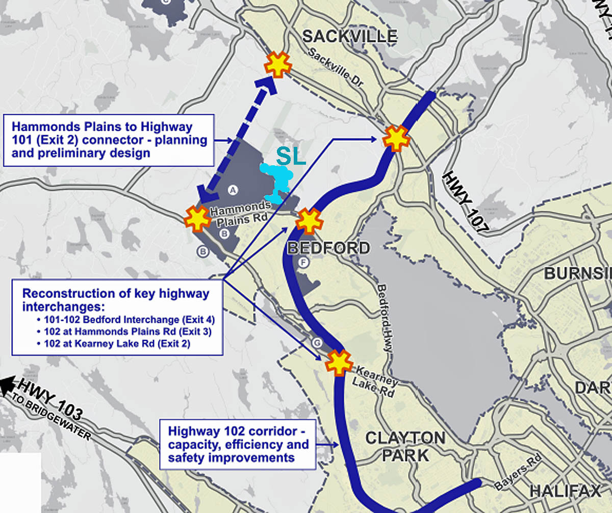
Extract from figure in Premier’s Office/Public Works News Release Oct24,2024 Inserted light blue coloration of Sandy Lake (SL)
So reads the heading for a NS Public Works News Release of Mar 16, 2026.
Among other impacts it would (will), with the Sandy Lake SPA, take out what currently remains of a significant wildlife corridor between the Chebucto Peninsula and the greater NS mainland.
From the News Release:
| The Hammonds Plains to Highway 101 connector project is now underway with a request for proposals issued today, March 16, for engineering services to prepare for an environmental assessment. The new five-kilometre strategic link will connect Hammonds Plains Road near Sandy Lake with Exit 2 on Highway 101.
Along with reducing congestion on surrounding roads, it will also create another way out of several neighbourhoods in an emergency. Transit routes could also be created or adapted in the area. Anyone who has driven in Halifax Regional Municipality has experienced the increasingly congested roads,” said Fred Tilley, Minister of Public Works. “This is the first step in this project which, combined with other projects planned for the area, will relieve congestion and improve safety.” The request for proposals calls for a consultant to assess potential environmental impacts in the project area. It will identify measures to avoid, reduce or mitigate effects on wetlands, wildlife, watercourses and nearby communities. |
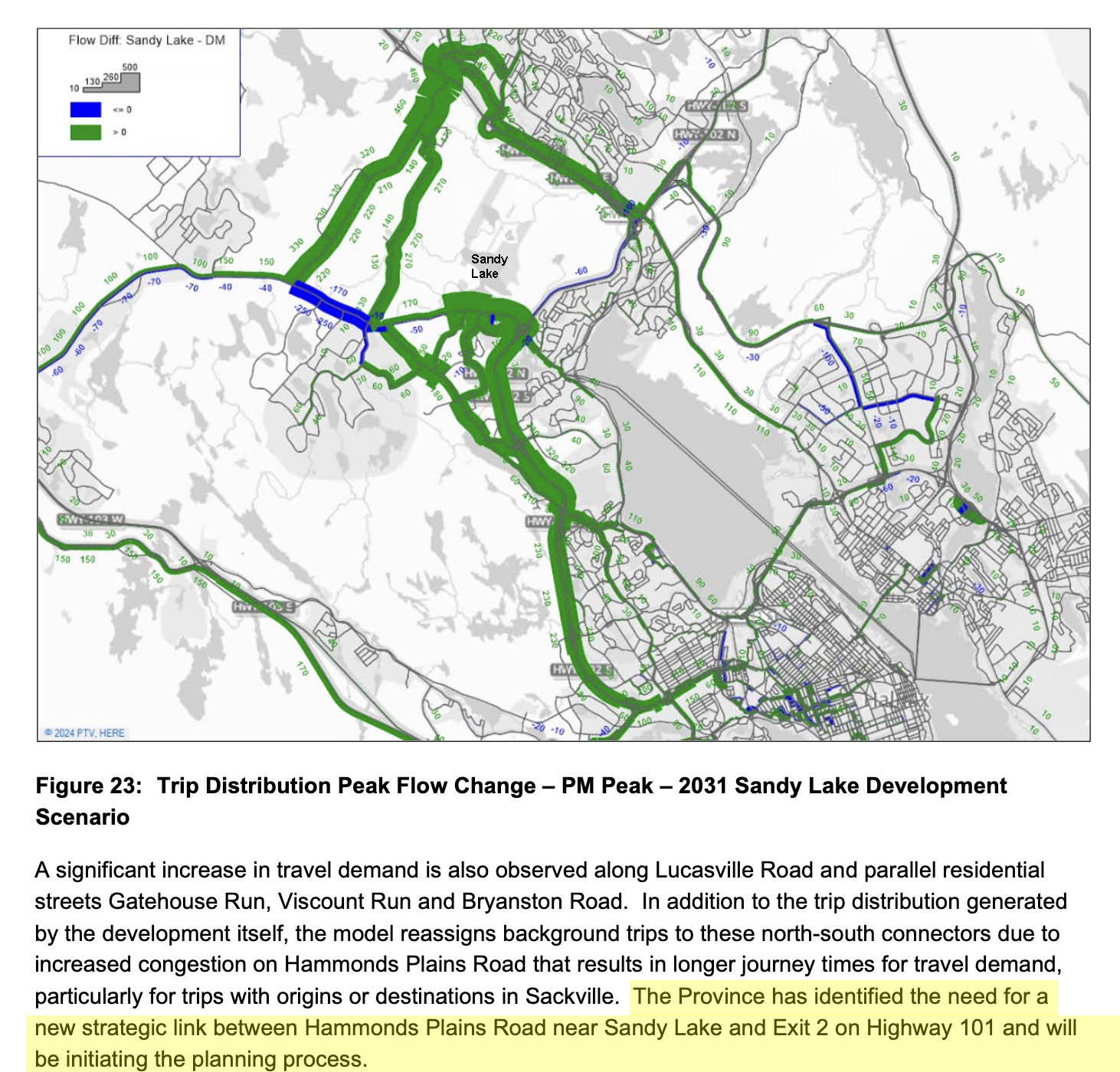
The Traffic Issue. From Stantec Transportation study
I guess the decision on whether to pursue “a more substantial connection from Hammonds Plains Road to Highway 101…via either a modified Lucasville Road or [a] new parallel corridor…” which “requires in-depth evaluation of environmental, community, and fiscal impacts” has already been made (re: the 2025 Stantec Sandy Lake Transportation Plan, pages 48-49).
Was there an in-depth evaulation of in-depth evaluation of environmental, community, and fiscal impacts” as cited in the 2025 Stantec Sandy Lake Transportation Plan?
I would have guessed that the modified Lucasville Road would have much less environmental impact than a new parallel corridor, if so, apparently community and fiscal aspects tipped the balance towards a new parallel corridor.
Some issues I hope will be addressed in the EA called for in the Mar 16, 2024 News Release:
- How would the Highway 101 Connector impact what currently remains of a significant wildlife corridor between the Chebucto Peninsula and the greater NS mainland, and what will remain of local wildlife corridors in the area after the residential development goes ahead ?[1] (see Notes below).
- How would the Highway 101 Connector impact wildlife habitat in this area, a hotspot of biodiversity?[2]
- How would runoff from the Highway 101 Connector impact salt levels in Sandy Lake and their possible effects on water quality and seasonal turnover of the lake?[3]
- How would the Highway 101 Connector impact water retention and downstream flooding during extreme storm events?[4]
- Could the Highway 101 Connector be constructed without a significant risk of releasing highly acidic water from acid slates in the northwestern region of the watershed into Sandy Lake/upper Peverill’s Brook?[5]
Related In The News Items
– Project to connect Hammonds Plains Road to Hwy. 101 now underway
By Chris Halef for CityNews
– Highway 101 connector project sets off alarm bells for Ecology Action Centre
Ben Dornan · CBC News, Mar 16, 2026.
Notes
1. On the remnant wildlife corridor between the Chebucto Peninsula and the greater NS mainland: see Maps and discussion in Wildlife Corridor Landscape Design Charrette:Chebucto-Timberlea-Sandy Lake area of Halifax, NS. Summary Document. Nova Scotia Crown Share Land Legacy Trust, Halifax, NS. Canada. 55pp, “In the absence of focussed effort and action, development will continue to encroach on rapidly narrowing options and opportunities to maintain or restore ecological connectivity between the Chebucto Peninsula and the greater Mainland, and effective foreclosure soon will become the inevitable and ultimate outcome.” Related to local wildlife corridors: see Wildlife Corridors (Page on this website); also view Sandy Lake Ecological Features Assessment 72 page document prepared for HRM by McCallum Environmental Ltd. June 27, 2022
2. On wildlife habitat, see: Wildlife (section of this website); and Sandy Lake Ecological Features Assessment 72 page document prepared for HRM by McCallum Environmental Ltd. June 27, 2022
3. On salt levels in Sandy Lake and possible impacts on seasonal turnover, see, Addendum 1: Trends in Conductivity/Salt Content; and Mirror Lake – Sandy Lake comparison; also relevant, but to date ignored: The Current State of Sandy Lake
4. Related to water retention and downstream flooding. The Sandy Lake watershed is the largest or 2nd largest sub-watershed in the Sackville River Watershed (the rank depending on how sub-subwatersheds are aggregated); as well known, the communities of Bedford and Sackville on the Sackville Rivers floodplain area experience excessive flooding during intense rainfall events. Regardless, the possible impacts of significant development in the Sandy Lake Watershed on downstream flooding were not modelled in the 2017 Sackville Rivers Floodplain study nor, apparently, in a subsequent update. Surely that must now be rectified to take into account the major new development now planned in an area of concentration of headwaters for Sandy Lake and the additional hard surface that would be introduced by the Highway 101 Connector.
5. On the acidic slates, see
– Conrad et al., 2002: “The northwestern region of the watershed is underlain with slate. This slate has the possibility of releasing amounts of acid if exposed to the surface, which will accumulate in the runoff and be carried to low lying bodies of water. Possible evidence that acid may be created in this area is the fact that the northern inlet (see Figure 6.1) to Sandy Lake is extremely acidic, with a pH of 3.38. The origin of the stream is at the edge of this slate.”
– 3.5 Acid Slate Hazard (this website). The same site sampled on Aug 21, 2017 had a pH value of 5.7. Discussion of poss impacts on aquatic biota.
– AECOM 2014, p.19 Fig 7 Constraints Mapping showing area of “Bedrock with Acid Generating Potential” and related discussion in Section 3.5 “Acidification from the exposure of sulphide bearing bedrock can reduce the pH of watercourses in HRM (White and Goodwin 2011). The slates of the Cunard Formation, the Beaverbank Formation and the Halifax Group are especially prone to producing acid drainage when exposed to the air. These slates occur in the extreme northwest part of the Sandy Lake watershed.
 “In the absence of focussed effort and action, development will continue to encroach on rapidly narrowing options and opportunities to maintain or restore ecological connectivity between the Chebucto Peninsula and the greater Mainland, and effective foreclosure soon will become the inevitable and ultimate outcome.” – Source: Wildlife Corridor Landscape Design Charrette:Chebucto-Timberlea-Sandy Lake area of Halifax, NS. Summary Document. 2021. Nova Scotia Crown Share Land Legacy Trust, Halifax, NS. Canada. “In the absence of focussed effort and action, development will continue to encroach on rapidly narrowing options and opportunities to maintain or restore ecological connectivity between the Chebucto Peninsula and the greater Mainland, and effective foreclosure soon will become the inevitable and ultimate outcome.” – Source: Wildlife Corridor Landscape Design Charrette:Chebucto-Timberlea-Sandy Lake area of Halifax, NS. Summary Document. 2021. Nova Scotia Crown Share Land Legacy Trust, Halifax, NS. Canada. |