
I paddled the shores of Sandy Lake, except for a bit at the northeast corner (which I covered later in August) on Aug 10, 2017. The purpose was to provide a preliminary documentation of the wetlands that fringe the lake. Specimens of the aquatic plants were taken for ID, and many landscape photos.
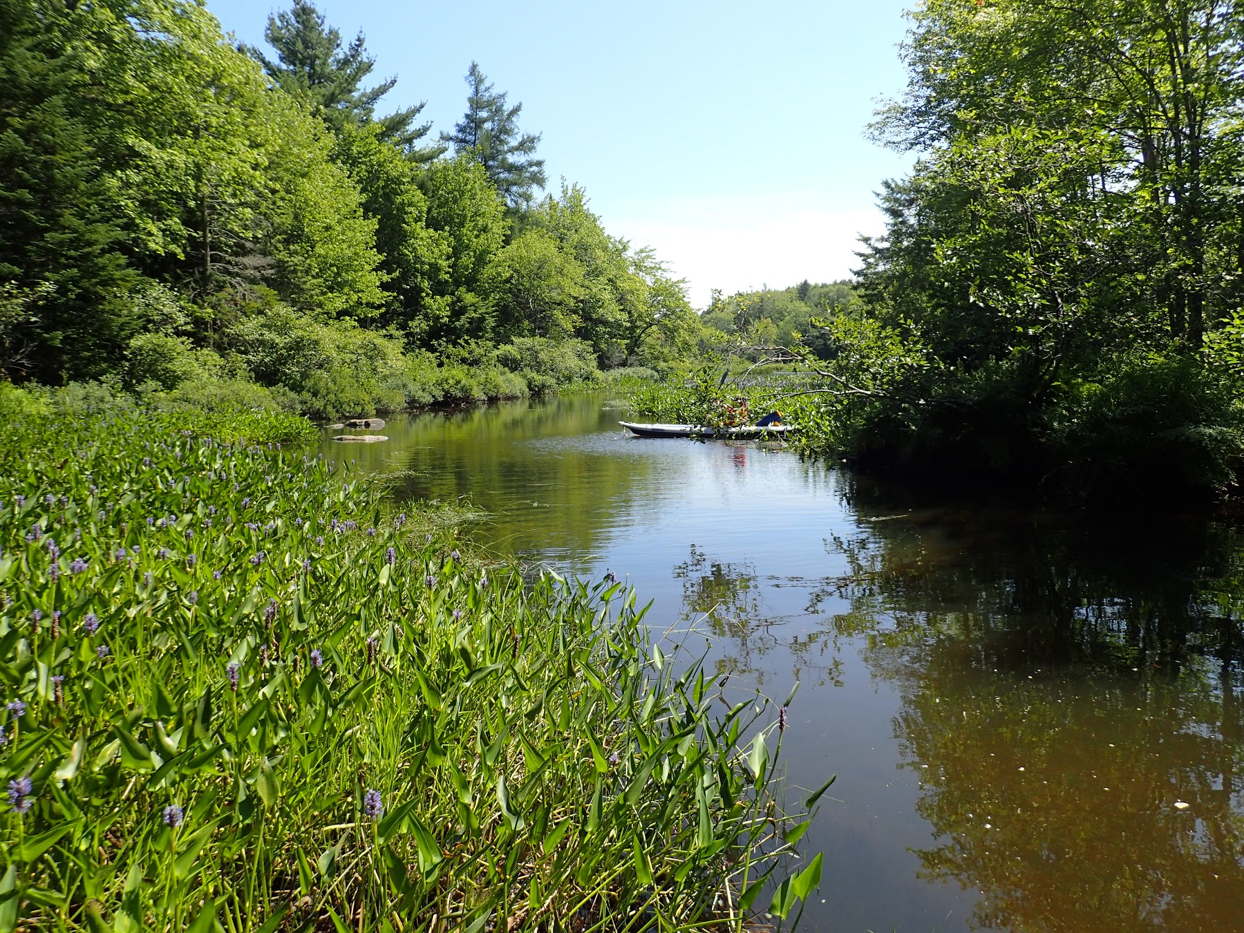
Marsh close to the inlet at the SW corner of Sandy Lake
There is relatively narrow band of emergent wetland vegetation, I am calling them “fringing wetlands” – or next to none – along the borders of Sandy Lake except at
– the extreme Southwest where there is a major inlet to the lake,
– the southeast corner
– around “the peninsula” in the second southeast corner
– the northwest corner of the lake.
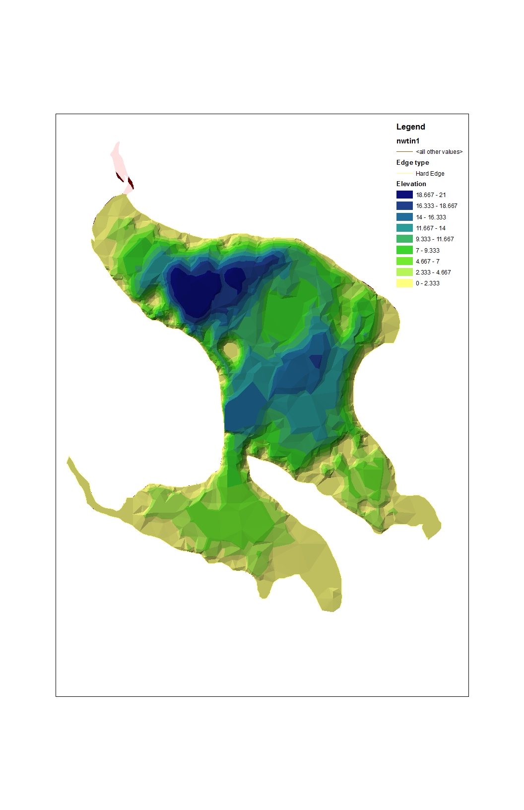
These latter areas correspond to broader, shallower areas viewable in Ed Glover’s Lidar image of Sandy Lake. There, emergent aquatic plants occupy more than half of the shallow water areas, and some places grade into swamp and then floodplain forest.
Three species account for most of the emergent vegetation we see in the fringing wetlands: Juncus militaris (bayonet rush), Schoenoplectus tabernaemontani (syn Scirpus validus, softstem bulrush), and Pontedariadata cordata (pickerel weed). The bayonet rush is by far the most abundant. The softstem bulrush occurs on a limited stretch of shore line just north of the Sandy Beach Park. Pickerel weed is most abundant towards the edges of the broader shallower areas. Another 10-15 species are common (I am working on a species list/photos.)
Ecological role of the fringing wetlands
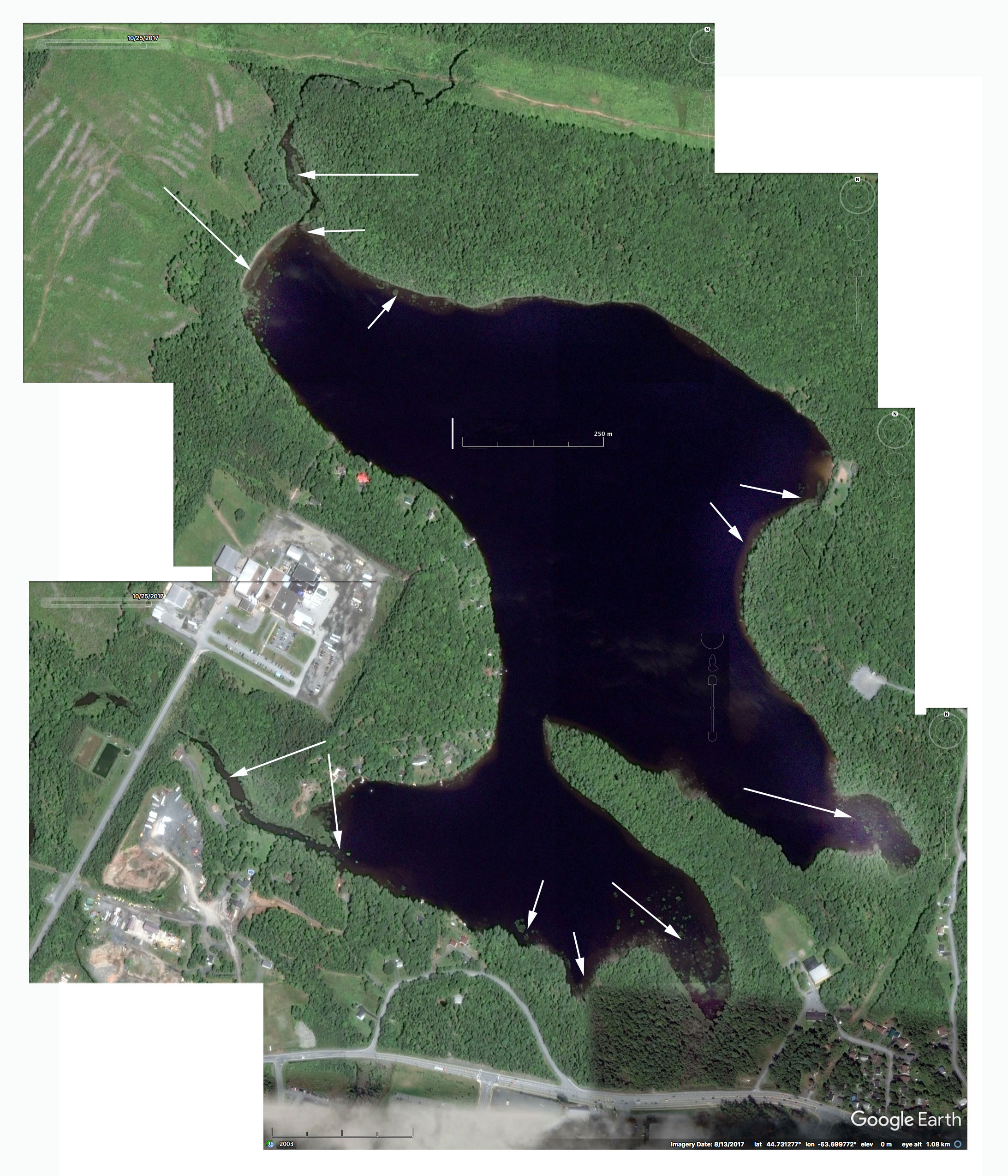 Areas of substantive fringing marsh on Sandy Lake viewable on Google Earth; streams enter the lake in these areas; or leave the lake (Peverill’s Brook at the extreme north of the lake). Click on image for larger version |
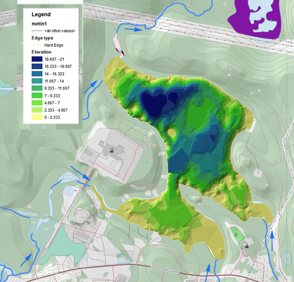 Ed Glovers Bathymetric Map of Sandy Lake superimposed on Provincial Landscape Viewer Map; streams are highlighted (smaller ones are not shwn on PLV). Emergent aquatic plants are found over most of the shallowest areas. Click here for larger/more extensive map. |
The fringing wetlands play vital roles in the lake ecology. They stabilize the shorelines, trap silt and organic debris coming in via streams, and provide protective habitat for frogs, turtles, and nesting loons, amongst other species.
Frogs are especially abundant in the fringing wetlands which afford protection from the voracious smallmouth bass always nearby. I observed a greater abundance of bullfrogs and green frogs and their tadpoles in the fringing wetlands on Sandy Lake and on the watercourse down to Marsh Lake (likely through to the Sackville River) than I have seen anywhere in Nova Scotia. I was told by a lakeside resident that leopard frogs were much more abundant and bull frogs less abundant in the past. (Wood frogs are common in vernal pools in the forests.)
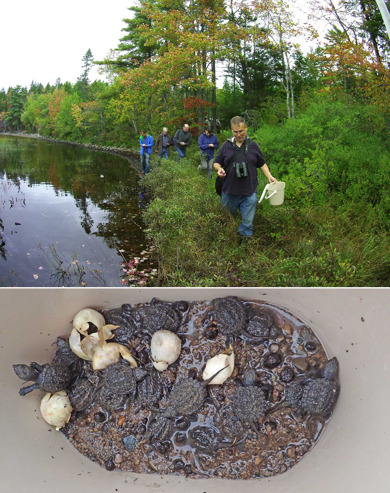 Snapping turtles are found on Sandy Lake, and wood turtles (listed as “threatened” in NS have also been been reported. According to Clarence Stevens of the local Turtle Watch group (and a well known Halifax area naturalist), snapping turtles were once present in 25 Dartmouth area lakes, today only in three. Snapping turtles were added to our Species-at-risk in 2013, where they are listed as “vulnerable”. Clarence Stevens released fledgling snapping turtles into fringing wetland by Sandy Beach on October 7, 2017.
Sandy Lake supports a large population of smallmouth bass; introduced to Nova Scotia in 1942, the fish was reported in Sandy Lake in 2000 and today is commonly caught by sports fishers. They are voracious feeders, thus these fringing wetlands are likely important protective habitat for amphibians and reptiles, as well as systems that produce abundant food for the fish population.
Traditionally Sandy Lake has supported a pair of loons which usually nest somewhere in the broader expanses of wetland at the south end of the lake, far enough from shore to avoid predation by land predators such as raccoons, weasels, and skunks. (On shallow rocky lakes in Nova Scotia, they nest on small islands away from shore; there are no such islands in Sandy Lake.)
Two food items I noted in the fringing wetlands were discarded shells of a freshwater mussel (Pyganodon cataracta), and the exposed, partially eaten roots of Pickerel weed. River otter are seen regularly on Sandy Lake. The otters eat “mostly fish such as minnows, perch and trout, river otters will also eat other aquatic items like clams/mussels and crustaceans, as well as frogs, muskrats, birds (particularly young waterfowl), eggs, insects and even turtles” so evidently are well supported by Sandy Lake. A local resident said he has seen beavers eating the roots of pickerel weed.
Aquatic plants as indicators
One purpose in documenting these wetlands is to provide a monitoring baseline. The emergent aquatics are readily visible. Changes in the species and extent of the major emergent aquatics could indicate changes in variables not so readily measured such as trophic (nutrient) status.
It is notable that the bayonet rush predominates the fringe wetlands, except closer to the mouth of the inlet at the southwest corner. It is notable because it is an Atlantic Coastal Plain species typically found in oligotrophic (nutrient poor) lakes, and not in more nutrient rich lakes (e.g. Srivistava et al. 1995 and Nicholls et al., 2015). So its dominance and also the relatively low species diversity of the wetland fringes seem to suggest that currently the lake is not experiencing significant eutrophication, i.e. is a “healthy lake”.
Species more characteristic of higher nutrient status are found close to the mouth of the inlet at the southwest corner (documentation tin prep.) In that area, the more extensive wetlands are likely acting as a “nutrient sump”, tying up excessive nutrients coming in via HP Brook. So there is a delicate balance in the lake, and we can look to the emergent aquatics as indicators of the state of that balance.
Restricted distribution of the softstem bullrush
Scirpus validus the softstem bulrush is largely or wholly restricted to a piece of shoreline just north of Sandy Beach. Over the more northerly part of its distribution, bayonet rush also occurs but outside of the softstem bullrush; there is little direct overlap. Proceeding northward, bayonet rush increases and the softstem bulrush declines and disappears after you go by the small headland. DS said the section of the shore where softstem bulrush occurs is a little pocket that is better protected from predominant winds than elsewhere on that shore.
Photo Albums
View
- Sandy Lake (Bedford, NS): Wetland Fringe
Aug 10, 2017 - Upper Peverill’s Brook Aug 15, 2017
Aug 15, 2017 Sandy Lake drains into Upper Peverill’s Brook, it flows into Marsh Lake and continues as Lower Peverill’s Brook to where it drains into the Sackville River. I have not yet viewed Lower Pevrill’s Brook. - SL: Marsh Lake/Peverill’s Brook
Aug 17, 2017 Marsh Lake As the name suggests, Marsh Lake, much shallower than Sandy Lake, has extensive wetlands.

Bayonet Rush