 Sandy Lake Ecological Features Assessment
72 page document prepared for HRM by McCallum Environmental Ltd. June 27, 2022
View announcement and document
Also view the update on this post: Council passes the boundary study motion unanimously
BACKGROUND
On Nov 9, 2021, Halifax Regional Council directed the “Chief Administrative Officer to direct staff to retain an independent consultant to direct staff to retain an independent consultant to assist with expediting the preparation of a staff report and recommendation for the purpose of identifying an optimal conceptual boundary for an expanded Sandy Lake Regional Park based on environmental information about the area considering:
“a) The natural vegetation buffers required to protect the water quality and reduce downstream flooding of Sandy Lake, Sackville River, associated tributaries and wetlands.
“b) The size of park needed to protect the multi-aged and old growth Acadian Forest in the area and documenting the habitats at Sandy Lake for their potential to support species at risk.
c) The locations of wildlife corridors that should be established to protect wildlife both within the park and movement through the area between the Chebucto Peninsula and mainland Nova Scotia.
“d) Identification of a secondary, western trailhead.”
The 72 page study, dated June 27, 2022 was released to the public on July 8, 2022 with recommendations by staff to be addressed on July 12, 2018.
It was noted that “The study context and assignment did not include a consideration of human values, including considerations for matters such recreation potential, which would be essential in the delineation of conceptual park boundaries and trailhead location. A future western trailhead was not specifically identified but the findings of this Study should allow the planning team to consider an appropriate trailhead location with ecological characteristics in mind.”
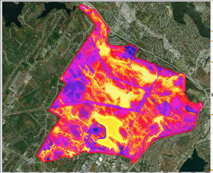
Figure 8 provides a striking graphic of ecological sensitivities:
From the description (p 34 of the report): “The final ecological features heat map visually represents the areas of the Sandy Lake Study Area that are of higher or lower ecological value based on the chosen characteristics (28) representing important ecological values. These characteristics were chosen to be able to identify “hot spots” relative to other areas in the Study Area. As shown in Figure 8, the features that scored the highest (bright yellow) were mainly aquatic or riparian features focusing around Sandy Lake, Marsh Lake, Jack Lake, and the Sackville River. There is a distinct corridor of high scoring features surrounding the Sackville River that highlights the importance of this system and its surrounding habitat. Marsh Lake has been identified in other studies as being of high importance to the larger ecosystem and this is again reflected in its scoring in this analysis. Given that these
two areas were identified as high scoring features and are aquatic habitats, protecting open water and riparian areas should therefore be a key consideration in further park and development planning.
The medium (orange) values represent areas of mature forest and habitat that are important to avian species at risk as well as important corridor areas and should also be considered for park and development planning. Maintaining connectivity through these medium scoring areas also supports the overall success of the high scoring riparian features. As was expected, the industrial or urban areas (ie – Agropur Cooperative – Farmers Dairy) scored low (blue).These areas include impermeable surfaces and human disturbance that are negatively impacting their value. ”
July 12, 2022: Boundary Study Motion
From the Agenda for July 12, 2022:.
15.1.10 Case 23952: Sandy Lake Ecological Features Assessment [Large 10 Mb PDF]
Motion:
That Halifax Regional Council direct the Chief Administrative Officer to:1. Incorporate the analysis and findings of the Sandy Lake Ecological Features Assessment in the planning and development of Sandy Lake Park.
2. Review and use the findings of the Sandy Lake Ecological Features Assessment in the background studies being undertaken for the Sandy Lake Special Planning Area, including organizing the form and location of development to best protect:
a. the suggested widths for important corridors,
b. the suggested riparian and watercourse buffers, and
c. the identified areas of predicted old or mature forest.3. Explore the use of conservation easements as part of the Sandy Lake Provincial Special Planning Area background studies to manage ecological features or corridors that extend outside of the conceptual park boundary.
4. Assess how to best organize land use and green infrastructure as part of the Sandy Lake Provincial Special Planning Area Background Watershed Study to mitigate any downstream impacts to the Sackville River and Sackville River Floodplain.
Council passed the boundary study motion unanimously (moved by Counc. Blackburn, Seconded by Counc. Outhit)
Link to Council discussions vote: https://www.youtube.com/watch?v=Lc_IcYMRJ44
In regard to item 2a above (the suggested widths for important corridors), from page 3 of Item No. 15.1.10 Halifax Regional Council July 12, 2022:
Landscape Connectivity
Corridors that allow wildlife to move through the study area were also analyzed. The relationship to wildlife movement at a regional scale is considered through the Halifax Green Network Plan, the Sandy Lake Ecological Features Assessment also considered the Wildlife Corridor Landscape Charette, which can be found on the Regional Planning website, and is catalogued as submission C1142. The Sackville River was identified as an important and essential corridor for its role in providing aquatic connectivity downstream. An important corridor was also identified along the west side of Sandy Lake that provides a connection for wildlife from the south of the study area to the Sandy Lake Regional Park. The Green Network Plan identifies that wherever possible, a width of 100 m should be maintained for Important Corridors and 1,000m for Essential Corridors.
In regard to item 2 b above, (the suggested riparian and watercourse buffers) were respectively 100 m and 50 m (re: page 3 in Item No. 15.1.10 Halifax Regional Council July 12, 2022; and page 33 in the Sandy Lake Ecological Features Assessment attached to Item No. 15.1.100
In regard to item 2c above, (the identified areas of predicted old or mature forest), Fig 7 on page 28 in the Sandy Lake Ecological Features Assessment identifies areas of predicted old and mature forest.

