
Click on image to enlarge them
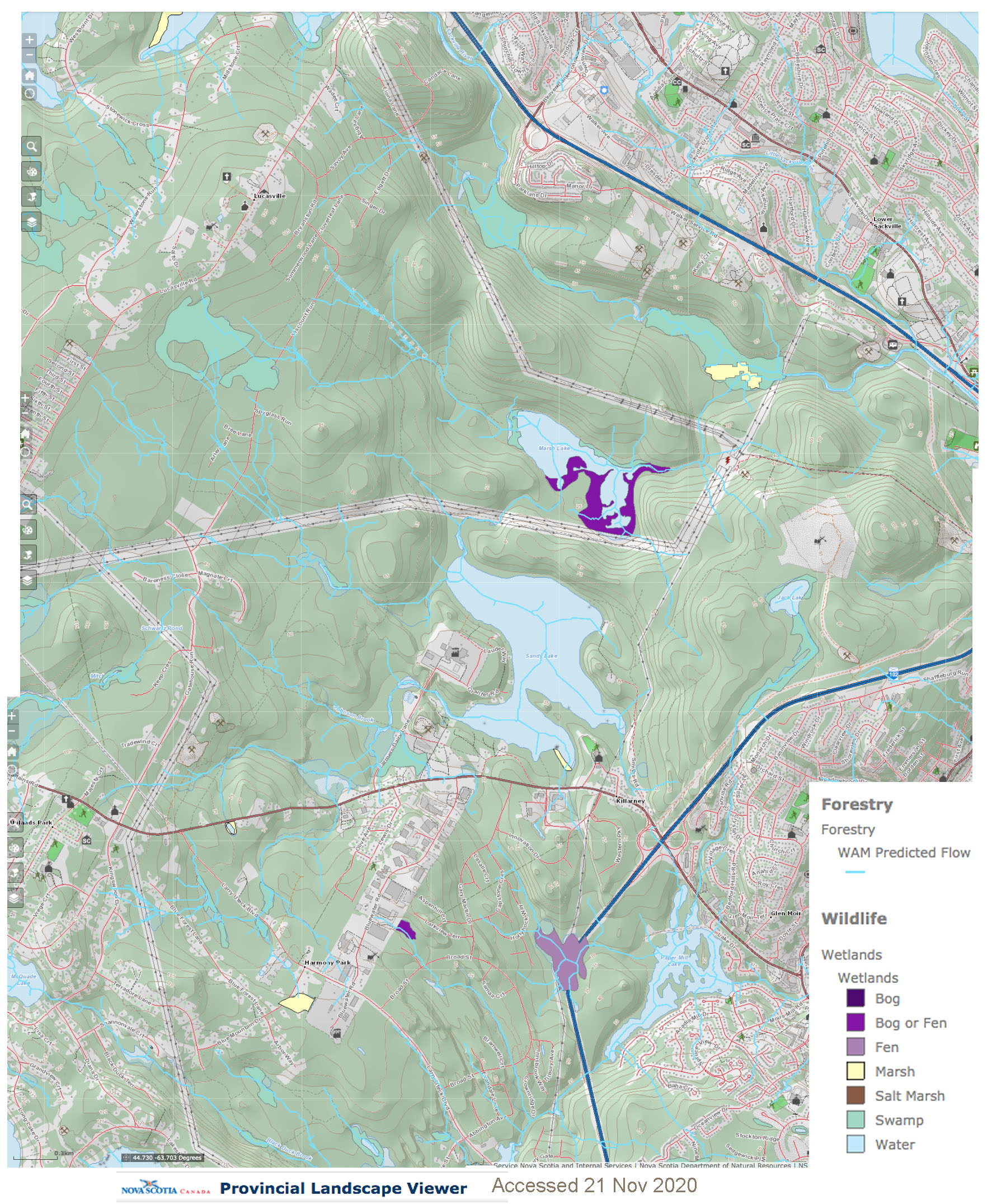
Wetlands and WAM Predicted Flows from Provincial Landscape Viewer
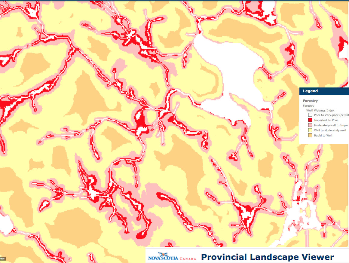
Wetness for region west and wouthwest of Sandy Lake from Provincial Landscape Viewer
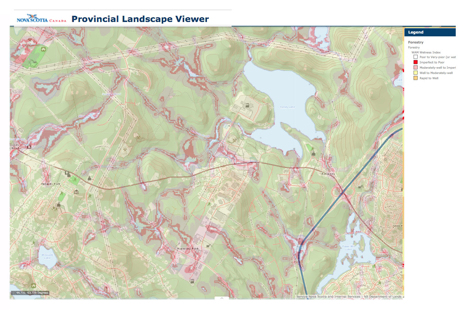
Wetness, with flow map partially transparent
“The WAM model predicts where water will naturally flow and/or accumulate in the landscape based on digital elevation (DEM) data and the known location of surface water bodies and wetlands. In essence, WAM is a “cartographically derived depth-to-water index…WAM is a very useful tool for suggesting where water flows and accumulations may occur in the landscape.” NSDNRSOURCE
Also view: Using the Cartographic Depth-to-Water Index to Locate Small Streams and Associated Wet Areas across Landscapes Barry White et al., 2012. Canadian Water Resources Journal Vol. 37(4): 333347
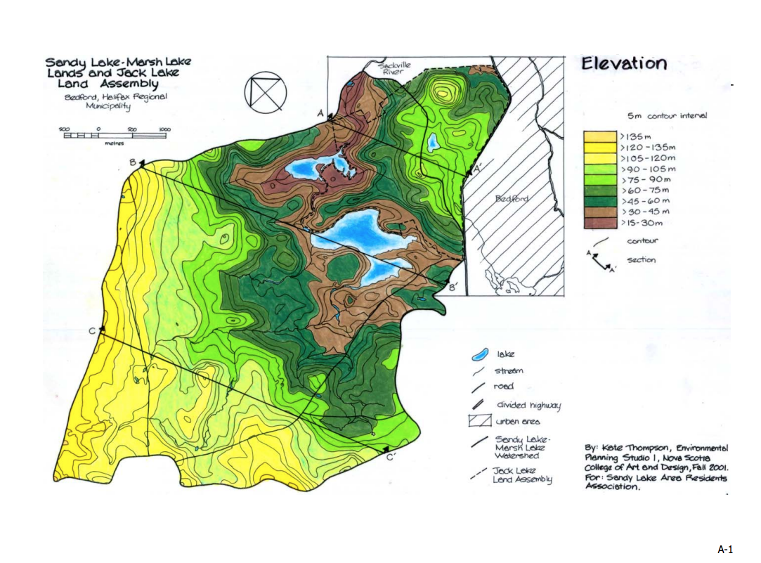
From Sandy Lake – Marsh lake Lands and Jack Lake Assembly: An Environmental Inventory, Analysis and Synthesis. By Kate Thompson, 2001. Prepared for Sandy Lake Area Residents Association
FROM AECOM REPORT (2014)
These images are screen captures. Go to the AECOM Report for better images
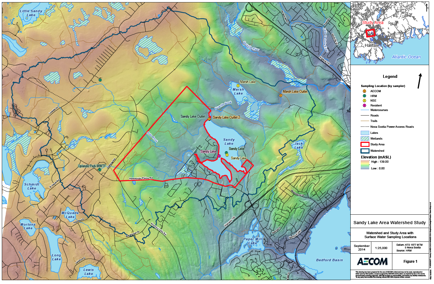
Figure 1: Watershed and Study Area with Surface Water Sampling Locations
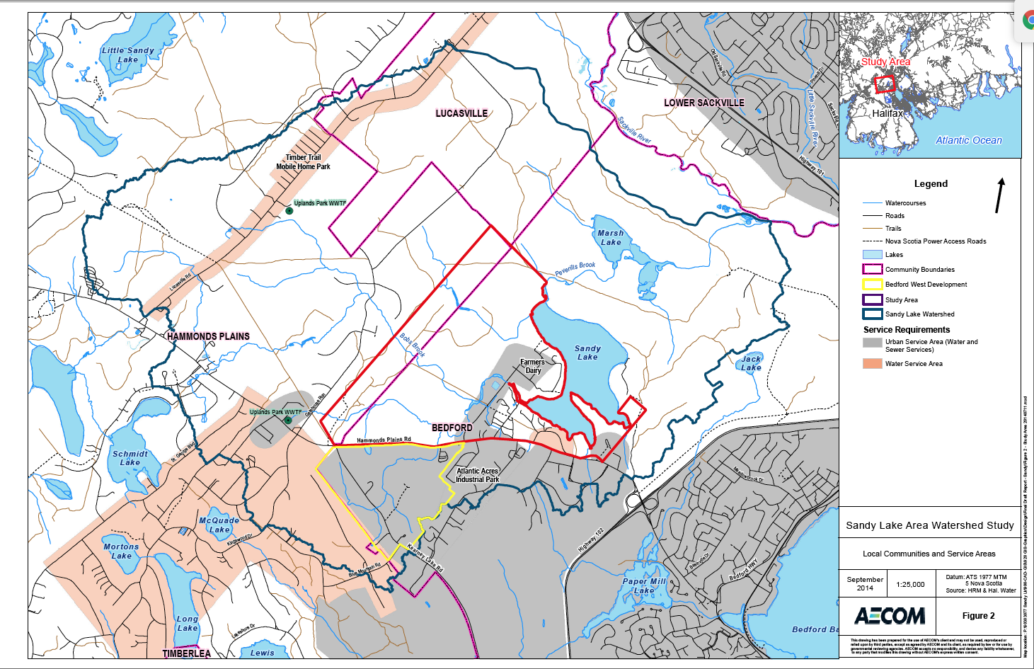
Fig 2: Local Communities and Service Areas

AECOM Fig 3 Wetlands & Forest Cover
From AECOM: “The vegetation in the Sandy Lake watershed is typical of mixed hardwood and softwood forests in southern Nova Scotia. Higher proportions of hardwood are found on drumlins and upland soils while softwoods are more common in low lying area with poorly drained soils (Neily et al. 2003). The forests within the watershed have been harvested for lumber several times in the past two hundred years, resulting in a mosaic of forest types of various ages and species composition (Thompson 2001). The area covered by forest is defined as area with >70% forest cover using data from NSDNR forestry inventory. Approximately 48% of the surface area within the watershed is currently occupied by forest (Figure 3). Mature hemlock forest has been identified on the southern peninsula of Sandy Lake. Orchids and lady slippers have reportedly been observed near the shorelines of Sandy and Marsh Lakes (Dalhousie 2002).
Approximately 85 ha of the watershed are wetlands, which make up about 3.5 % of the watershed area. This is a small proportion relative to the size of the watershed and suggests the watershed is well drained.”
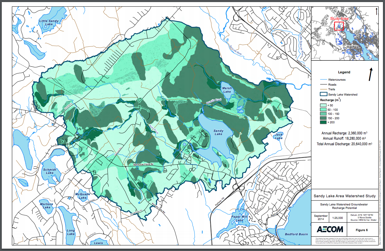
AECOM Fig. 6 Groundwater.Recharge Potential
From AECOM: “Groundwater recharge rates were estimated for the Sandy Lake watershed using a GIS based groundwater recharge model (Appendix D). Groundwater recharge occurs throughout the study area, but is greatest in areas where the slope is moderate, vegetative cover allows for infiltration and the soils are coarse grained and permeable. Areas with higher recharge are shown on Figure 6. These areas are in the drumlin-rich areas north and east of Sandy and Marsh Lakes extending toward the Sackville River. Areas with high groundwater recharge rates are ecologically valuable since they produce cool, clean baseflow to streams, lakes and wetlands during low-flow periods. They also represent areas of potential groundwater vulnerability since pollutants released at surface can access deeper potable water aquifers though the recharge path. The protection of these areas is a priority identified in Regional Plan Policy E-17.”
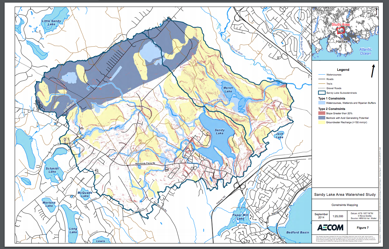
AECOM Fig 7 Constraints Mapping
From AECOM: 3.3 Development Constraints
The potential impacts of development on water quality in Sandy Lake can be mitigated, to a degree, by the implementation of effective planning strategies. To this effect, a constraints map is developed for the Sandy Lake watershed identifying areas that are not suitable for development and areas that are suitable for development, but may require environmental controls to mitigate potential impacts on surface water quality. Consequently, a constraints map (Figure 7) has been developed. Two categories of constraints are identified; Type 1 and Type 2. Type 1 constraints are for areas where development is not recommended to occur to protect water quality. Watercourses, wetlands and watercourse buffers are considered Type 1 constraints. Type 2 constraints are for areas where methods to protect the environment may be required if development occurs in these areas. Areas with high groundwater recharge, areas underlain by acid generating bedrock and slopes greater than 20% are areas recommended for Type 2 constraints.
The Type 1 constraints include watercourses and associated buffers surrounding the watercourses. A review and analysis of setbacks and vegetated buffers in Nova Scotia was undertaken by Hydrologic Systems Research Group (2012) indicating the effectiveness of buffer widths varies depending on the pollutant of interest. For sediment and phosphorus, a 5 m buffer will remove an estimated 50% of these pollutants. The 20 m buffer along all water courses used in the constraint analysis is reported to eliminate more than 70% of suspended sediment and more than 60% of phosphorus (Hydrologic Systems Research Group 2012). As illustrated in Figure 7 we have assumed there will be an automatic 20 m setback for all development along watercourses, wetlands contiguous with watercourses, and lakes. This buffer should ideally be retained in a natural vegetation state to reduce overland flow during storm events and to provide a buffer zone for nutrients, pesticides and other pollutants from developed areas both during and following construction.
Type 2 constraints are reserved for areas suitable for development but may require additional environmental controls. Areas with steep slopes (>20%) are more likely to erode and contribute sediment to watercourses. The areas in Sandy Lake watershed with slope greater than 20% are identified in Figure 7 and are recognized as development constraints in the watershed. Prior to development, these areas should be assessed to evaluate if erosion is likely based on the occurrence of bedrock (less likely) or surficial deposits (more likely). If development proceeds in these areas, sediment control methods are recommended to prevent high sediment loads from entering the watercourses.
Acidification from the exposure of sulphide bearing bedrock can reduce the pH of watercourses in HRM (White and Goodwin 2011). The slates of the Cunard Formation, the Beaverbank Formation and the Halifax Group are especially prone to producing acid drainage when exposed to the air. These slates occur in the extreme northwest part of the Sandy Lake watershed. The areas underlain by the Cunard Formation, the Beaverbank Formation and the Halifax Group rocks (Figure 4) are designated as Type 2 constraints. Development in these areas will be required to follow the Sulphide Bearing Materials Disposal Regulations under Section 66 of the Environment Act.
Areas with high groundwater recharge potential are important to groundwater users and the lakes and streams in the Sandy Lake watershed. The groundwater recharge model completed for the Sandy Lake watershed used surficial geology, slope and vegetative cover to predict how precipitation is partitioned into groundwater recharge and surface runoff. Areas with high groundwater recharge (>150 mm/yr) provide pathways for water to enter the groundwater system. Protecting these areas with high recharge is important to the groundwater quantity of the watershed which is utilized by water source wells and contributes to the hydraulic budget of the lakes in the watershed. Protecting these areas also protects groundwater quality in the watershed because they are potential pathways for contaminants to enter the groundwater system. Therefore, areas with recharge >150 mm/yr identified in Figure 6 are included in the development constraints as a Type 2 constraints. It is recommended that areas identified to have high groundwater recharge potential are suitable for development with conditions that allow for recharge rates to be maintained, such as:
Restricting the types of development to developments with low risk for groundwater contamination; and
Implementation of groundwater quality protection measures to avoid groundwater contamination.