On the Natural History of the Sackville River
I referenced this page titled just “Natural” on the Sacjkville Rivers Association website in 2020: http://sackvillerivers.ns.ca/sackville-river-watershed/history/natural/ on Dec 6, 2020.
May 7, 2024: That content is no longer posted on the active website, but most of the content is available on the web archive, copied below.
Sackville River SS1
Location
The Sackville River flows in a more or less southerly direction into Bedford Basin on the Atlantic coast of Nova Scotia. The mouth is in the community of Bedford, Lat. 44° 44′, Long. 63° 40′. The headwaters is in the Mount Uniacke area, and the stream flows through Upper, Middle & Lower Sackville, with a branch from the Beaverbank area & one from the Hammonds Plains area.
General Description
Sackville River is about 25 miles long and drains an area of about 60 square miles. The lower part of the river basin was originally an area of small mixed farms and lumbering was extensive in the upper portion. In this area there are acres of clear cutting near the river with tops and slashing left on the banks. Now, however, Sackville is Halifax’s fastest growing suburb and the lower part of the river basin is almost entirely residential area, moving outwards rapidly and taking up more and more of the basin.
Sackville River flows through a valley of granite and glacial fill. The gradient is moderate, but in some areas the stream is very rough and boulder strewn. 5, Between these rough areas there are long, deep dead waters flowing through swamps. In a few areas the stream flows moderately over gravel bottoms and forms riffle areas. The banks are variable from low swampy areas to steep cliffs as high as 50 feet.
This river is a fast run-off river with very high flows in spring and after heavy rains. At such times the velocity is very high and the river overflows its banks and makes new channels in many low areas. In mid-summer the river is just a small stream flowing between the boulders.
This flooding problem in such a populated area has led to several miles of the lower part of’ the stream being channelized and re-routed, and it is a number of years since any homes have been flooded. Ten years ago, flooded basements were an annual event.
This system has fifteen lakes, several of them quite large, and a number of ponds and still waters. Highways 1, 101 and old route 1 more or less parallel this river throughout its length, although in some places it is quite far removed from any of these roads. In the lower parts of the brook there are housing developments and other roads to the river in several places. In the upper portion small wood roads and lumbering roads give access to the river from Highway 101.
Tributaries
The largest tributary to the Sackville River is Little Sackville River. The Little Sackville is about 5 miles long and drains an area to the east of the main river. It originates in two small lakes in the Beaverbank area – Little Lake and Feely Lake. This stream has a gentle gradient and a meandering course. There are housing developments all along this river and roads parallel it and cross it in many places. There is a sawmill on this brook that has operated for many years.
The Little Sackville River formerly flooded its banks each spring and endangered houses along the river. The flooding has been controlled by channelization and re-routing of the river.
Tributary SSlB is a fairly large brook joining the main stream from the west. This stream is about five miles long. It drains Marsh Lake and Sandy Lake. Sandy Lake, like many others on this system, is surrounded by housing developments, and there is a large dairy manufacturing plant being built on the shore in 1974. The countryside around this stream is very rough and hilly. A large swamp surrounds Marsh Lake, and in fact, the new map shows the lake to be twice as large as the old map does.
Thompson Run is tributary to McCabe Lake from the west. It originates in Beaver Lake and Bottle Lake, and also drains Sandy Lake. These three lakes are inaccessible by road, and surrounded by dense woods. Thompson Run enters McCabe Lake through a large swamp area. There are about 2 miles of stream on Thomson River.
Tributary SSIF enters the north end of McCabe’ Lake from the east. – It drains two small lakes, Little Springfield Lake and Drain Lake. The outflow of these lakes is a small rocky brook. The stream between the two lakes flows through a culvert under highway 101.
Tributary SSIG joins the main river just above McCabe Lake. It drains Tomahawk Lake, one of the largest lakes of the system, and Beaver Lake, a smaller lake. This is a different Beaver Lake from the one on Thompson Run. There are about 4 miles of stream on SSIG. In addition, there are a number of small ponds and swamps on this system. SSIG drains an area to the west of the main river, between the Sackville River and Pockwock Lake.
SSIH is the tributary, which joins Lewis Lake to the mainstream and SSlJ, joins Pentz Lake to the river. Both Lewis Lake and Pentz Lake are centers for large housing developments
Fish Species
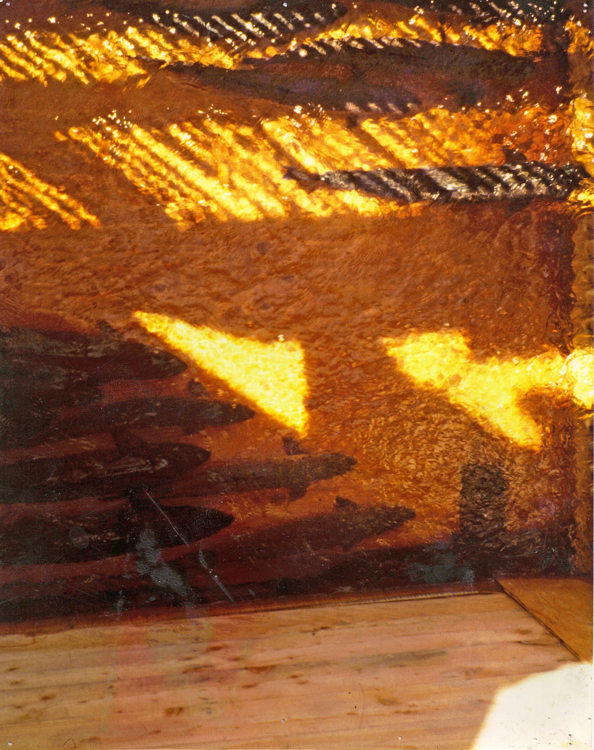
Historically, the Sackville River was a very good salmon river for its size. Records show that in the 18th century a fishing party took 45 salmon from one pool on the Sackville River in 1 day. In the 1940’s and 1950’s the Department of Fisheries maintained a fish hatchery at the mouth of this stream and utilized salmon from the stream for brood stock. Runs have declined since then and it is popularly believed that there are no longer salmon in the river. However, one fisherman reports catching a salmon there in 1974, and salmon fry and parr have been found by electrofishing.
The run of salmon in this river was a spring run, occurring early in the year during the snow melt run off. Spawning areas are not abundant on this stream, since much of the bottom is composed of boulders. However, there are some stretches of gravel in the lower main stem and in the lower Little Sackville. There are small patches of gravel scattered throughout the stream where the current is moderate. The extent of salmon migration is not known, but the only barriers are at the headwaters of the Little Sackville River. Most of the stream is open to salmon now, although there were barriers in the past.
The Atlantic salmon is an anadromous fish (spawning in fresh water but spends the majority of its life in salt water), and is renowned for phenomenal journey from the waters off south eastern Greenland, through the North Atlantic, to spawning beds in the rivers of Ireland, the United Kingdom, Canada, the Faroes Islands, Iceland, Norway, Sweden, Finland, Russia, France, Spain, and the United States. However, due to disturbance and pollution, many essential salmon runs have become extinct. Many individuals and organizations are now trying to raise awareness of the disappearing salmon runs, as Atlantic salmon are essential for the livelihood of many ecosystems and animal habitats as well as Atlantic heritage


Trout are not abundant in the Sackville River. There is some angling in the lakes, and Tomahawk Lake is believed to provide good fishing, but the success on the rest of the stream is low. No trout were found by electrofishing on the lower mile or so of stream, although this part of the stream appears to be good habitat for trout.
Gaspereau run up this stream in large numbers in late May and early June, when the water is high. Local people dip gaspereau for their own use and children dip them to sell to neighbors. A good place to dip gaspereau is at the foot of the falls just below Webber Lake. The distribution and spawning areas of the gaspereau are not known, but since they spawn in lakes, it is the opinion of department personnel that they must pass this falls and spawn in Webber Lake. If Webber Lake is accessible to them, they can pass beyond it to McCabe Lake and the still waters above it, and quite possibly to most of the other lakes feeding the Main Sackville. The two lakes on the Little Sackville are above the dam at Barrett’s Mill.
Large catfish and suckers are also found in this stream and are sometimes angled by children.
Barriers
In the past dams at various places along the stream have obstructed the Sackville River. Most of these barriers are now gone. There was a dam at the mouth of the river for the fish hatchery, one at the foot of Webber Lake, one for Hefler’s Lumber Mill, one at the foot of McCabe Lake, and one above McCabe Lake on the main stream. All of the above are gone, and there are no remains in the stream bed, so no obstruction to fish passage remains.
On Little Sackville River there have been two dams in association with Barrett’s Lumber Mill for many years. These dams are still maintained and they are both total barriers to fish passage. Above these two dams there are 2 small lakes and a very short length of stream.
On tributary SSlB, Sandy Lake Brook, there was formerly a dam between Sandy Lake and Marsh Lake, one at the outlet of Marsh Lake, and one dam near the headwaters of the stream. All three of these dams have been completely breached.
There were formerly dams at both the outlet,’ and inlet of Tomahawk Lake. These have both been breached so fish passage is possible right through Tomahawk Lake and into Beaver Lake. However, the planned new Halifax City Water supply utilizing the Pockwock system also includes Tomahawk Lake, so it appears that Tomahawk Lake will be diverted into that system.
On tributary SSIH at the foot of Lewis Lake there is a small dam of rocks placed in the stream. It is only about 2 feet high and backs the water up about 3 feet.
The culvert on tributary SSIF between Drain Lake and Little Springfield Lake is probably a barrier to fish passage in times of low water. Only Little Springfield Lake is above this culvert.
A partial obstruction to fish passage is found just below Webber Lake where there is a waterfall. The water drops about 20 feet in a horizontal distance of 20 feet but the falls is probably no barrier to fish passage during times of high water. There is another small waterfall above McCabe Lake. It is not a barrier to fish, at least during high water.
There is a diversion dam at Royce Hefler’s mill just below Webber Lake. Local people call this lake Hefler’s Lake. The dam only extends partway across the stream, so that fish can always pass it. The dam diverts water into the millpond to hold logs above the mill.
Water Quality
The water in Sackville River is dark brown in color. It is usually clear but it is frequently turbid after heavy rains, or when construction work in the area is carried too close to the stream. Siltation has been a particular problem in the Little Sackville River, the first mile or so of the main stream, and in Sandy Lake. The pH of the stream was found to be approximately 7 at all sites that were tested. The water temperature was quite variable from 72° to 80° with the air temperature in the eighties. These temperatures were in the lower part- of the stream. Further up, where the velocity is faster, and the stream more shaded, the temperature is lower.
In many places the rocks in this stream are covered with a slippery brown algae. There are some places where there is old sawdust in the stream bed, and sometimes-fresh sawdust is seen during high water.
Treated sewage enters the main river just below the confluence of Little Sackville River. Most of the homes on the watershed are hooked up to the sewage treatment. facility. Untreated, raw sewage enters Little Springfield Lake from a trailer court on its shore. In the past two years this lake has changed from its former brown color to a bluish green color_ and a foul odor is present all over the lake. The water appears soapy.
The lower part of the river is strewn with garbage from the highway, local residents and a drive-in restaurant. There have been incidents of wastes from the chicken being dumped on the banks of this stream.
In the Sunnyside area what appears to be a storm sewer empties into the river. The water at the outflow of this pipe was a blue color. The hardness of the water in this stream tested at 1 gram per gallon of CaCO3 and the iron content registered at more than 10 ppm. This is a very high iron reading.
Water Uses
Tomahawk Lake is destined to be used as part of the Halifax City water supply, but no work has yet been carried out on this diversion.
Sandy Lake (SSlB2) was designated by MAPC as a prime recreation lake that should be protected for recreational use of local people. A dairy processing plant has been built on this lake. The people who live on its shores use it for recreation.
Pentz (Swan), Lewis, and Little Springfield Lakes are all near housing developments and are popular swimming and boating areas. There is a new housing development planned for the land near Webber Lake, and its recreational use can be expected to increase when this gets underway.
The two lumber mills make use of water from the stream but this water is restored to the stream right below the mills, as clean as it went in.
Formerly a large gravel crusher operated in this stream, and the wash water was returned. to the stream without settling. This crusher has been closed down.
Stream Alterations
For many years the lower end of Sackville River has been cribbed along bath sides to prevent erosion. More recently a large area just above Sunnyside that was formerly low lying swamp subject to frequent flooding has been landfilled for development. Above the landfill long stretches
of the river was bulldozed and straightened when highway 101 was built along the bank and a section of the river was moved to the west. In these sections the channel was deepened and large boulders were removed from the watercourse. Pools and rapids that formerly existed along here are now obliterated and the riverbed is much more uniform.
About 2 miles above the mouth of the river, a large stream alteration has been brought about by the action of a gravel crusher working in the stream and along its banks. An area about _ mile long and _ mile wide was devastated, and many deep holes and side channels were left. These fill with water in the spring only to be cut off as the water level goes down. The temperature in these small pools becomes very high and in very dry years they dry up completely. Just upstream is another smaller gravel pit with similar damage but to a much smaller extent.
The Little Sackville River has also been subject to alterations to suit man. It too was channelized along Highway 101. In 1974 a section was bulldozed for a new bridge crossing-for Highway 1.
The proposed diversion of Tomahawk Lake and its tributaries from the Sackville system to the Pockwock system for Halifax City Water Supply will remove 5.8 square miles from the drainage area, including one of the largest lakes on the system.
Other Remarks
The Salmon Management and Salmon Development Section of Fisheries has a proposal to introduce an artificial run’ of salmon into this river to develop a recreational fishery here.
Click here for the history of the fishway.
Sackville River Dam History
Check out this progress report published by the Nova Scotia Water Power Commission on the dams of the Sackville River up until September 30th, 1916.
Sackville River Dam Report
Sackville River Watershed Species
[The original had photos with each species; not available on web archive]
Monarch butterflies
Wood Turtles
Short Eared Owls
Ring Necked Snakes
Freshwater Clams
Sea Run and Resident Brook Trout
Bicknell Thrushes
Atlantic Salmon
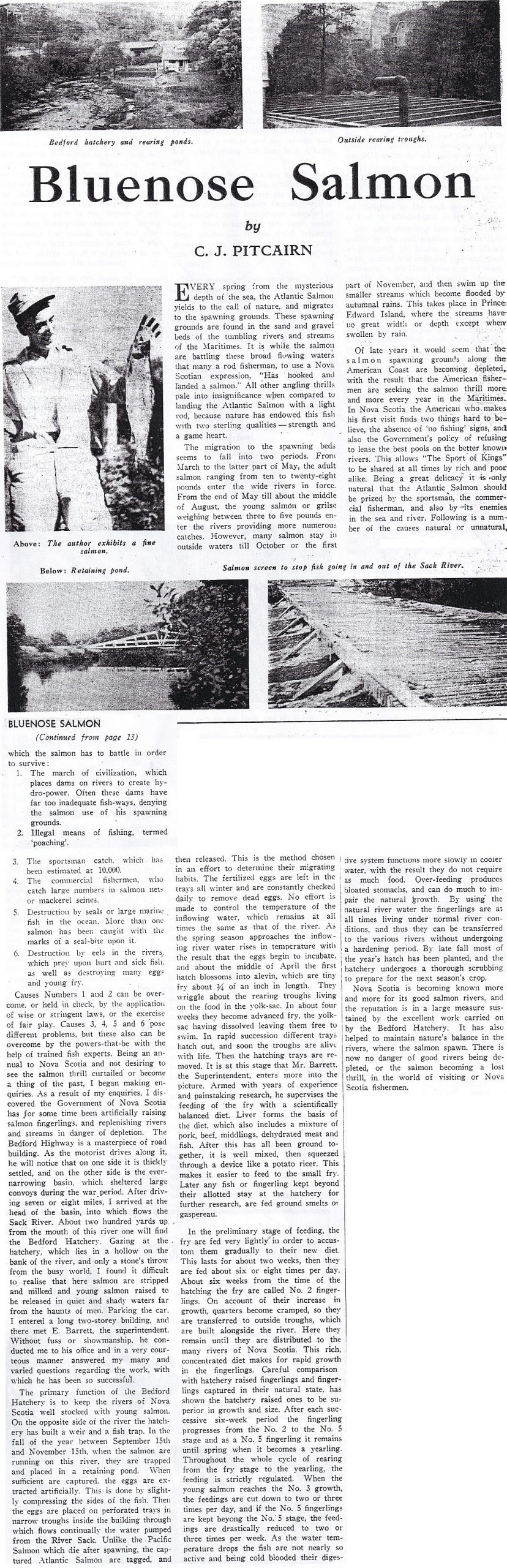
Click below to read the 1950 Bluenose Salmon Article.
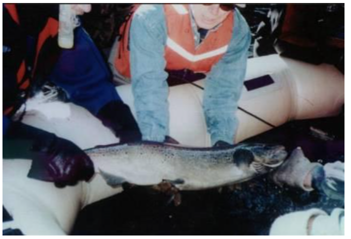
The first photo in 50 years of salmon in the Sackville River.