
From AECOM 2014:
– Sandy Lake watershed occupies 2422 ha (22.4 sq kilometers)
– Sandy Lake is 78.5 ha
– Marsh lake 21.5, not including “the wetlands surrounding the lake”
– Approximately 48% of the surface area within the watershed is currently occupied
by forest
– Approximately 85 ha of the watershed are wetlands, which make up about 3.5 % of the watershed area
The AECOM 2014 Report provides maps showing current settlement, and makes use of specific figures for different categories of land use to calculate phosphorus loading, but these figures are not available in the report (I will try to get them).
Mandel 1994 calculated urban land use percentages for 1967 and 1986 as 0 and 21.09%, and attributed the change to loss in forest cover which he estimated as 100% (except for surface waters) in 1986.
I have estimated the % settlement of the Sandy Lake Watershed in 2014 (View Map) as 29.2%.

The area within the polygons is 29.2% of the total area within the Sandy lake sub-watershed.
Casey Doucet 2022, estimated the value as 21% – the approximate (interpolated) value from her Fig 2.2 – in 2020. The average between 29% (my estimates and 21% (Casey Doucet) is 25% for the period 2014-2020.
Major New Development, Impending and Proposed
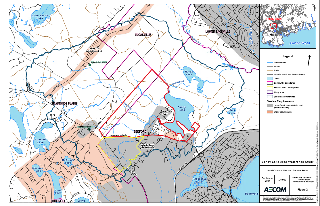
AECOM 2014 Fig 2 Local Communities and Service Areas. Low-res screen capture image, see AECOM Report for better image. The map also shows watershed boundaries, watercourses, roads. The area below Hammonds Plains Road enclosed in a yellow polygon is the Bedford West Development Sub Area 12 for which development is planned but detailed policies to enable that development have not yet been produced. The area above HPR enclosed in the red polygon includes the area of the Proposed Sandy Lake West Development, described in the AECOM 2014 Report.
From AECOM 2014 3. Development in Sandy Lake Watershed
3.1 Historical and Existing Development
Hammonds Plains Road is one of the oldest roads in Nova Scotia, historically connecting Lunenburg to Halifax. It bisects the southern portion of the Sandy Lake watershed and is still used as a primary commuter route by many residents of Hammonds Plains and nearby villages. Lucasville Road connects Hammonds Plains Road to Sackville and cuts across the northwestern portion of the watershed. The Sandy Lake area initially used the water and wood resources to operate lumber mills in the 1800s. Residential development of Sandy Lake began in the 1900s with the establishment of cottages and agricultural land. The area was utilized primarily for recreation and seasonal or full-time residence until the 1970s. Beginning in the 1970s development included the Farmers Dairy on 45 acres west of the lake, Peerless subdivision and the 112 acre Atlantic Acres Industrial Park. The development of Atlantic Acres Industrial Park included the infilling of Verge’s Marsh with rock and peat. In 1978 the Pockwock Lake water supply for Halifax was completed, including a main supply line across the western portion of the watershed and a secondary line south of Sandy Lake. Kingswood subdivision south of Hammonds Plains Road was developed in the 1990s and contains hundreds of homes. Although it is serviced by municipal water, residents use individual septic systems for their wastewater treatment. Subsequently, the Kingswood North subdivision (north of Hammonds Plains Road) was developed. It currently contains 50-75 homes with additional residences under construction. Residents of Kingswood North have both private wells and private septic systems. Lucasville is located in the northeastern portion of the watershed and has hundreds of residents on private wells and septic systems, although municipal water is provided along the Lucasville Road itself (Figure 2).
In 1970, the Timber Trails mobile home park was established and expanded in 1998. It is currently occupied with 233 homes on Lucasville Road. It will be expanded by 167 units over the next 5 to 8 years. The mobile home park uses a private communal septic system to treat wastewater, but is in the process of having the wastewater treatment system upgraded.
In 2002, the Sandy Lake Lion’s Park and Beach opened as a public park on the eastern side of Sandy Lake. The Park contains a dog off-leash area, parking for 100 cars, a 450-person capacity artificial beach, public washrooms and change rooms (Conrad et al. 2002).
In 2002 a set of studies were completed by Dalhousie for the Sandy Lake Area Residents Association which documented environmental conditions (Thompson 2001), demographics and development history (Dalhousie 2002a) to provide a set of recommendations for managing development in the watershed (Dalhousie 2002b). In 2009, an HRM commissioned report (CBCL 2009) provided cost estimates for servicing water, sanitary, stormwater and transportation links using various development scenarios in the ‘Greenfield’ area near Sandy Lake. In 2012, HRM Council agreed to oversize wastewater infrastructure through Bedford West to service potential future development of the Sandy Lake Greenfield area. In 2013 Armco Communities, developer and largest land owner, initiated forest clearing within the watershed. Armco Communities has since sold this property to Clayton Developments. As noted, HRM intends that future growth around Sandy Lake will be accommodated through central water and sewer services. A stormwater management plan will be developed by the property owner for approval by HRM and Halifax Water, in accordance with its Design and Construction Specifications guide book for the applicable calendar year (HRM request for proposal, this study).
A list of potential contaminant sources that may be present within the Sandy Lake watershed is presented in Table 1.

from AECOM (2014)
Wastewater in the Sandy Lake watershed is a source of nutrients (nitrogen and phosphorus) to the waterbodies that can impact water quality. Wastewater systems utilized in the Sandy Lake watershed include:
Septic Systems
Aging septic systems may not be effective at reducing phosphorus from water dispersed in the septic field. The systems may not function as designed because the system components are broken or corroded. The soils in the septic field exhaust their retention capacity and become saturated with phosphorus as the system ages. This saturation results in the discharge of phosphorus to groundwater and surface water that can increase the phosphorus load to lakes. In the Sandy Lake watershed there are no residences on Marsh Lake and there are approximately 20 residences situated within 300 m of Sandy Lake and approximately 200 residences within 300 m of watercourses. These residences rely on private septic systems to treat residential wastewater. In addition, trailhead peat toilets were installed at the Lion’s Beach Park in 2002. Given their proximity to the lake, all of these systems are potential sources of nutrients to Sandy Lake depending on their age and maintenance history.
Farmers Dairy
The Farmers Dairy facilities may have had impacts on water quality since it was constructed in the early 1970s. Erosion from areas logged prior to construction may have resulted in lake siltation in the early 1970s. Treated wastewater discharges from the dairy were associated with water quality impacts as reported by lakeside residents in the 1980s (Dalhousie 2002). The Farmers Dairy currently has a primary wastewater treatment facility consisting AECOM Halifax Regional Municipality Sandy Lake Watershed Study Final Report 2014 08 25 60303077 Sandy Lake Final Report 16 of two open-air lagoons. Discharge from the lagoons is directed to the municipal sanitary and the Mill Cove Wastewater Treatment Plant (T. Blouin, Halifax Water, pers. comm.).
Uplands Park – WWTF
The Uplands Park Wastewater Treatment Facility (Figure 1) was built in 1969 and consists of a primary clarifier, a trickling filter with rock media, a secondary clarifier, and hypochlorite disinfection. The plant has a rated capacity of 91 m3 /day with a peak capacity of 178 m3 /day, and serves a population of approximately 170 people. The effluent discharge criteria is 20 mg/L for both biochemical oxygen demand (BOD) and total suspended solids (TSS). In 2009 the plant was upgraded to ultraviolet disinfection (Halifax Water 2008). The plant discharges approximately 40 m3 of treated effluent per day into a wetland/creek approximately 3.5 km upstream of Sandy Lake (T. Blouin, Halifax Water, pers. comm.). In the early 2000s sewage leaks from broken sewer lines southwest of Sandy Lake affected lake water quality. Boil water and no swim advisories for Sandy Lake were issued by the municipality. Following the breaks, the force mains were replaced by Halifax Water (K. Mackenzie, Halifax Water, pers. comm.).
From p46, AECOM (2014):
Wastewater treatment facilities: The Uplands Park Wastewater Treatment Facility (WWTF) is located in the Sandy Lake watershed. It has been operational since 1969 and is a source of nutrients to Sandy Lake. The facility may overflow and bypass the treatment cycle during storms or malfunctions. Untreated wastewater discharge carries high nutrient loads, especially phosphorus and can significantly add to the natural and nonpoint loading of phosphorus to lakes resulting in their rapid eutrophication. The impact of the wastewater overflows is difficult to quantify for several reasons:
˗ Overflows typically occur during extreme weather events. The timing, frequency and severity of these events are not possible to predict and so the water quality impacts from overflows cannot be quantified or modeled.
˗ Halifax Water monitors the volumes and locations of overflows but does not measure the concentration of effluent released to the environment during an overflow event. Given this, it is not possible to gauge the nutrient loading that may occur during these events. We assume that reduction and ideally elimination of these overflows will be a priority within the plans for expansion of the waste water collection and treatment system within the watershed.
Timber Trails
The Timber Trails mobile home park is serviced by communal septic systems. In 2008, North West Community Council entered into a development agreement to enable an expansion of the Timber Trails mobile home park in support of upgrading its old sewage system. The old system had reportedly suffered from overflows and seepage during heavy rain events. As of August 2012, the park expansion has not occurred but detailed engineering of the new waste water treatment facility was underway (HRM Staff Report 2012). Since then, the waste water treatment facility has been upgraded but is not yet operational (A. Bone, HRM, pers. comm.)
From p 57: Timber Trails mobile home park: Timber Trails is serviced by a private communal septic system. Approximately 233 homes are located in Timber Trails and a proposed expansion of the park is conditional on improvement and expansion of the septic system. The septic system is a source of phosphorus, nitrate and bacteria to surface water and groundwater. In the past, the park has struggled with wastewater treatment issues such as overflow and seepage during rain events. The park is approximately 4 km from Sandy Lake, so it doesn’t represent a direct impact on the water quality of Sandy Lake. However, the septic system can impact local groundwater which is used for potable water supply in the area.
From p45, Non-point sources of pollution
Stormwater runoff
Stormwater runoff directs overland flow from developed areas through rudimentary drainage systems to streams and lakes. Sandy Lake is the primary receiving waterbody in the Sandy Lake watershed. Overland flow from developed areas represents a significant urban non-point source of pollution and contributes sediments, oil, anti-freeze, road salt, pesticides, nutrients and pet and waterfowl droppings to Sandy Lake. This urban runoff generally accelerates the eutrophication or natural aging process of urban lakes by adding
sediment and nutrients. The added nutrients can contribute to algal blooms, decreased water clarity, and an increase in the amount of rooted aquatic plants growing in the shallow near-shore waters of a lake. All of these can reduce the recreational value of a lake by hindering swimming, boating, fishing and reducing its overall aesthetics.
Road salt application: road salts pose a risk to plants and animals in the aquatic environment. Road salt application can also impact groundwater quality, leading to elevated concentrations of chloride in drinking water. HRM recognizes the potential impacts to surface and groundwater quality and utilizes several best management
practices to reduce the impacts when possible (HRM 2012). However, the application of road salts along Hammonds Plains Road and to a lesser extent on secondary residential roads contributes to chloride loading in Sandy Lake.
Deforestation
˗ Deforestation may impact water quality by increasing the organic content and sedimentation of runoff. Studies completed in the Pockwock watershed (NFA 2005) indicate the impact of deforestation on water quality is negligible when compared to the changes in phosphorus, chlorophyll-a, Secchi depth or pH from seasonal variations. However, best management practices for logging will limit the potential for impacts on
water quality from deforestation.