
NAVIGATION
This page is a sub-page of ObsBath, a top-level page on
the website Barbados Fringing Reefs and Seagrass Beds
(www.versicolor.ca/barbados).
Go to ObsBath for a list of other subpages in this section
of the website.
DRAFTING… Contents from a draft manuscript, 1999.
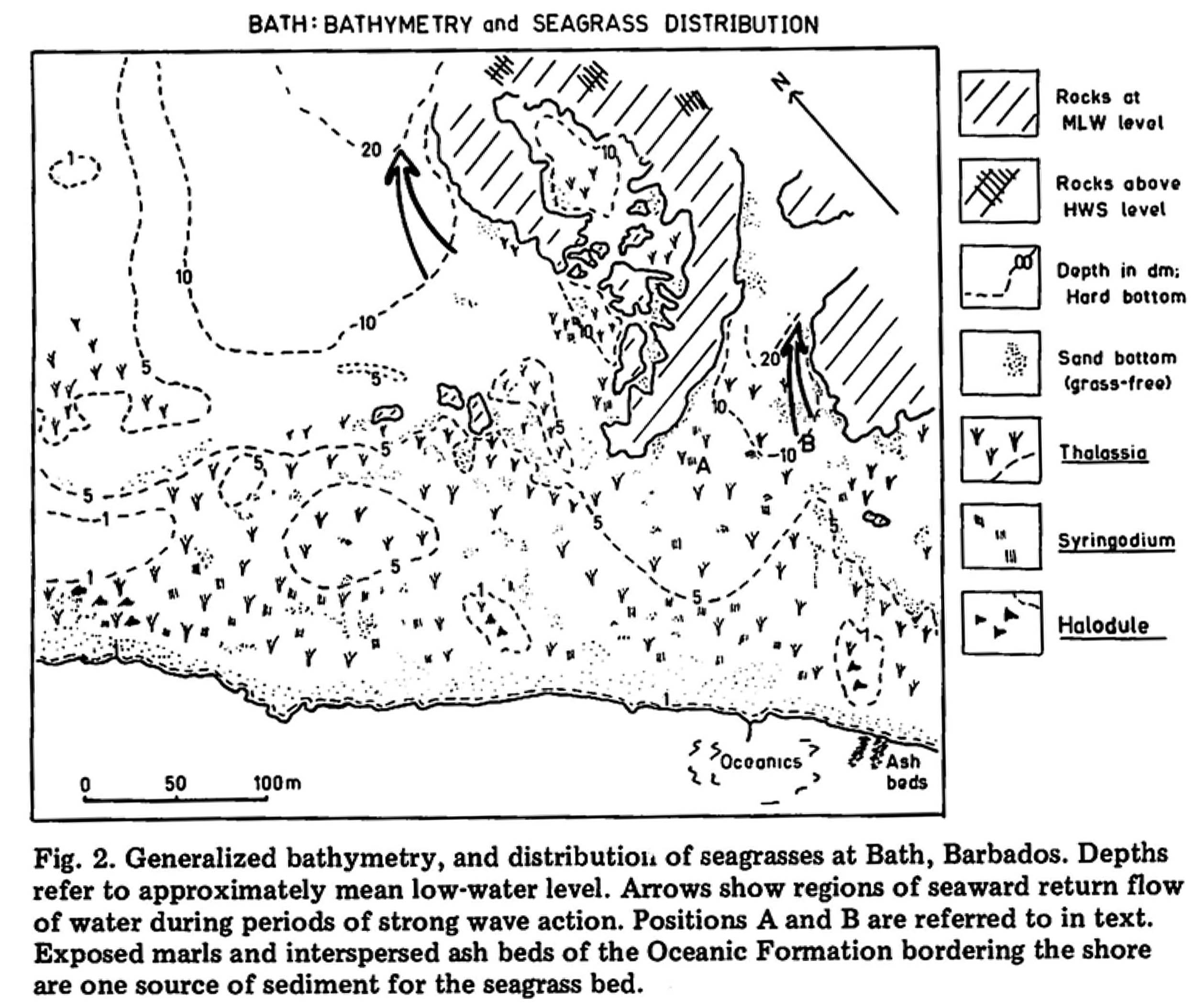 Fig 1 |
Fig 2 |
Fig 3. Depths and occurrence of T. testudinum (Tt) Syringodium filiforme (Sf), Porites furcata (Pf), Anrainvillea nigricans (An), Avrainvillea rawsonii (Ar), Cobble Framework substrate, Scarps on Transects M and 4S in 1969 and 1994. Depth of hard bottom (bedrock) inshore is shown for Transect M in 1969. For visual examples of the Consolidated bottom, see photos for Stations M and N in 2015.
Seagrass beds at Bath occur partially in the lee of algal- and coral-encrusted rocks rising to MLW level and above lying at 150-300 m from shore (Fig. 1). The beds have a complex topography and distribution of sediments as a result of the irregular topography of the bedrock, the complex wave regime, and prolific biogenic production of particles of clay to cobble size. The seagrass bed is shallow (mostly less than 1 m) and conditions are generally turbulent except for a few hours at low water; during the winter months, waves over the seagrass bed may reach one meter in height and Iongshore currents speeds in excess of 60 cm/sec (Patriquin 1975).
Four seagrass substrate types with well defined distribution were distinguishable in 1969 (Fig 2). These are
(i) Cobble Framework: T. testudinum-stabilized accumulations of cobble-sized rhodiles and coral debris at the seaward fringe of the beds;
(ii) Porites Rubble Flats: T. testudinum– and H. wrightii-stabilized accumulations of P. furcata debris rising to close to MLW nearshore which alternate with
(iii) Predominantly Sand: T. testudinum– and S. filiforme-colonized predominantly sand substrates; and
(iv) Cobble Sand: a mixed cobble-sand substrate stabilized by T. testudinum andS. filiforme occurring through the rest of the area (Fig. 2).
In Fig 3, topographic profiles, the distribution of seagrasses, Porites furcata and Avrainvillea spp and the occurrence of Cobble Framework substrate in 1969 and 1994 are presented for the two transects (M and S4 in Fig 2) which could be most accurately relocated in 1994.
In 1994, the Cobble Framework accumulations had largely disappeared from the seaward fringe of Transect M, the depth increased and the continuous seagrass cover of that area was broken up into patches (Fig. 3, M: compare profiles for 1969 and 1994 at 120 to 170 m; hatching shows the volume lost 1969 to 1994).
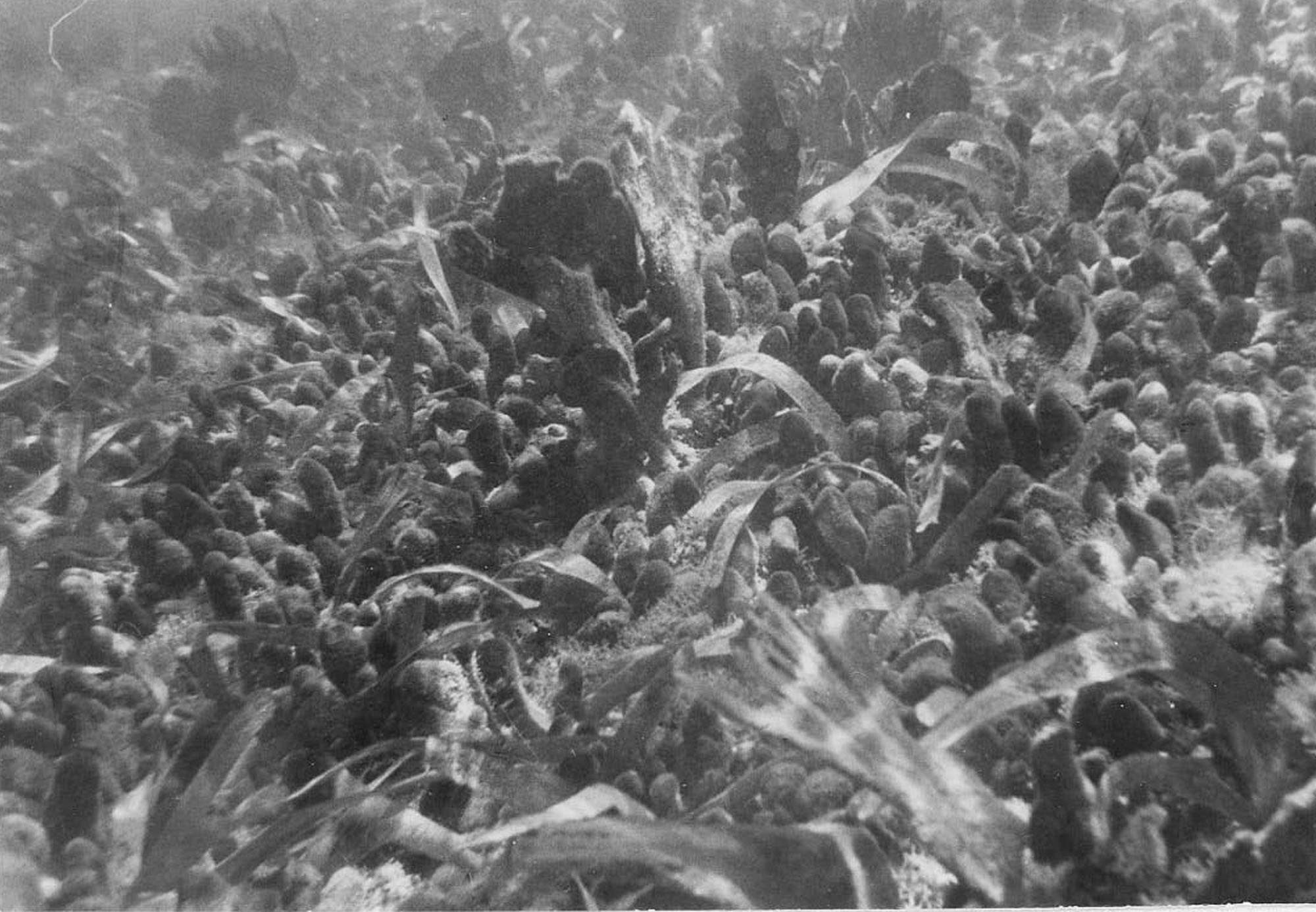
Fig. 5. T. testudinum stand overgrown by Avrainvillea rawsonii and Avrainvillea nigricans. The flabellate alga (A. nigricans) is approx 15 cm height.
In 1994, Cobble Framework substrates, and overall, much more coarse rubble were also observed shoreward of where the Cobble Framework had been in 1969 (Fig. 2, Transect M). Large areas of this Cobble Framework or mixed Cobble-Sand substrates were overgrown and stabilized by a carpet-like cover of the green algae Avrainvillea rawsonii and A. nigricans (Fug 5), which had been seen in only a few more restricted areas in 1969.
An erosional scarp in the region of Station C (Fig 2) revealed 10 t0 30 cm of rubble including rhodiles on top of Cobble-Sand substrate.
On transect 4S, there was an overall downward slope seaward (Fig. Profle 4S). In 1969, a bed of cobbles not exhibiting distinct relief, occurred at 2-3 meters depth over a distance of 20 m. In 1994, an area of Cobble Framework with distinct relief occurred shoreward of this area, and there was an overall pattern of greater relief and occurrence of cobble-sized materials towards shore.
These patterns suggest that a major storm event disrupted the cobble accumulations and moved much of that material closer to shore. I asked an elderly local resident whether he was aware of any major disruptions of this sort in recent years. He said that in the 1980s, wave action during a hurricane had deposited massive amounts of coral debris on shore one day, and then took it back to sea on the next day; it was the most severe storm disturbance of the Bath area that he could remember.
Discussion
The loss of the cobble-framework substrate at the seaward fringe of the Bath bed, and accumulation of similar materials inshore must be attributable to the severe disturbance described by a local resident.
The cobble framework substrate was well bound together by branching rhizomes of T. testudinum, thus a threshold type of disturbance would be required to disrupt its integrity,and strong wave action to erode it and carry the cobble-sized material away.
The resident was vague as to the precise year, however, a report by Nurse (1989) suggests that the likely event was Hurricane Gabrielle in September of 1989. Although its center was 600 km north-east of Barbados, it generated severe sea swells and wave heights of 3-3.7 m (the mean wave height for waves on th eeast coast is approximately 0.5m).
There are not detailed observations for Bath, but Nurse (1989) remarks that “an apparently powerful backwash carried much sediment seaward” which is consistent with the observations cited by the Bath resident that large amounts of rubble’ materials were washed onto shore one day and carried out to sea the next.
Comparison of the state of the systems in 1969 and 1994 suggest that this single disturbance led to other . changes that both reduced the carrying capacity o f the system for seagrasses, and stabilized it in this mode.
A number of factors could be involved: .
– The disturbance likely winnowed out much of the finer, organic matter and nutrient-rich . sediment from the sandier nearshore areas, removing~sources of N and/or altering~ conditions most favourable for N2 fIXation or adsorption and storage of nutrients, in thisstrongly N-limited environment (Patriquin, 1972; Patriquin and Knowles, 1972; Capone et ale 1979).
– Deposition of rubble on top of the T. testudinum-dominated beds and prolific overgrowth of much of it by Avrainvillea spp. stabilized the new configuration, restricted recolonization of seagrasses by preemptive exclusion (interference competition) and further reduced nutrients available to seagrasses (i.e., exploitative competition; REF)
– Shallowing resulted in increased wave disturbance at high tides, and more extreme conditions of heat when extreme low tides occur during the day; increased wave disturbance and a reduced protection of S. filiforme by the T. testudinum canopy (Williams, 1987) could further limit potential for S. filiforme to compensate for loss of T. testudinum.
Thus it appears that a single natural event caused a change of state, going from a mostly seagrass-dominated state to a mosaic of seagrass and Avrainvillea dominated communities. The latter state seems likely to remain in place until another severe disturbance, or chronic stress of some sort, e.g. affecting the Avrainvillea spp., causes it to change again.
There is no evidence to suggest that the change in state was associated with anthropogenic disturbance, however several factors which might have an influence on the biotic dynamics have changed in the interim,and they cannot be ruled out as contributing factors:
– First, after 1969, there was some dynamite fishing in the area of the offshore rocks. No large moray eels were observed in the area of the rocks during the 1994 visit, nor any large barracuda in the ssegrass beds which in 1969 were seen regularly; there were however, plentiful parrotfish and and surgeon fish in the vicinity of the rocks. Thus herbivory by fishes on seagrasses (add HAY REF) may have increased substantially.
– Second, in 1969 weeding of cane fields above the Bath shore was conducted manually, while herbicide use became common subsequently. In the 1980s, sea-island cotton was planted in the fields adjacent to the Bath seashore. Drainage from this field flows into the study area during periods of rain and renders the water at low tide very turbid when otherwise it is clear. Thus significant exposure to herbicides could occur periodically; fishers expressed concerns about possible impacts of herbicides on sea urchins (Scehibling & Mladenoc, 1987)
– Third, groundwater nitrate increased (2.0 mg/L, 1977; 8.4 mg mg/L in 1996), which is attributable to greater fertilizer-N use (Halcrow 1998)
REFS (many to add)
– Halcrow Group Ltd. 1998. Hydrogeology, terrestrial and manne water quality report.
Barbados Coastal Conservation Programme (Phase 1). Technical report to the
Coastal Zone Management Unit of the Government of Barbados. 116pp
– The Decline of the Sea Urchin, Tripneustes ventricosus, Fishery of
Barbados: A Survey of Fishermen and Consumers
by R.E. Scheibling and P.V. Mladenov. 1987 in Marine Fisheries Review 43(9): 62-67