
NAVIGATION
This page is a sub-page of Vauxhall Reef & Environs 2024.
Vauxhall Reef & Environs 2024 is a sub-page of ObsII a top-level page on the website Barbados Fringing Reefs and Seagrass Beds (www.versicolor.ca/barbados).
Go to ObsII to view a list of all pages and subpages under ObsII
April 19, 2024
Related: Video Transects of Vauxhall & 2 Degraded Fringing Reefs
Why is Vauxhall Reef (Reef No 34), apparently, much healthier overall than other fringing reefs in the MPA? Or alternatively, why are most of the fringing reefs seriously degraded?
Comments Robin Mahon, Professor Emeritus, Marine Affairs at UWI-Cave Hill in a 2019 paper*: “As regards coral reefs, direct physical destruction is relatively rare. There is no need: we have more or less destroyed them with a combination of pollution and overfishing.”
Overfishing has been minimized in the MPA though the ban on fishing. That, potentially, leaves pollution as the main threat. There is a fairly large scientific literature on effects of pollutants, especially nutrients, on Barbados reefs.
Mahon goes into more detail in regard to this threat in his 2011 paper, Achieving Sustainability in Barbados: Coping with Complexity and Uncertainty** under a section on “West Coast Gully outlets” (pp 157-161). An extract:
We hear a great deal about the Holetown Hole, how it has been degraded, stinks, dumps pollution and sediments out onto the reef. All of this is true, but how many people are aware that this is just one of about 16 substantial gully outlets on the west coast between Six Men’s Bay and Batts Rock. What about these, what is their condition, what problems are they creating and what goods and services have we lost with regard to them?
The gullies that feed these outlets form a series of watersheds along our west coast that drain about 20% of the island’s land area, but are in the area of the island where rainfall is highest. They empty onto a coastal plain of varying width with a sand and gravel substrate (Figure 1). We can only guess what the coastal plain was like before the island was extensively settled, but it is a fair guess that there were extensive seasonal wetlands all along the west coast associated with this string of gully outfalls.
…Functional west coast gully outlets would have been playing an important role in keeping land-based sediments and nutrients off the near-shore reefs, acting as filters and also preventing the large pulses of pollution laden water that come out of the concrete channels. These functions are even more crucial given the upstream changes in land use. Our west coast fringing reefs are substantially degraded. The extent to which this is due to the loss of gully outfall function relative to other activities is not known. It is likely to be due to the combined effect of many factors: gully discharge, groundwater seepage, swimming pool water discharge, direct sewage discharge, discharges from vessels and changes due to fishing.
_________________
*Progress with environmental sustainability in Barbados in 50 years of independence
Mahon, R. 2019. CERMES Technical Report No. 96, 31p.
**Achieving Sustainability in Barbados: Coping with Complexity and Uncertainty
R Mahon. 2011: pp 152 to 167 in Preserving Paradise, S. Carrington (Ed) A series of lectures to commemorate the life and work of the late Dr. Colin Hudson. Barbados Museum and Historical Society, St. Michael, Barbados. Includes a section on West Coast Gully Outlets, with maps, photos.
Over the course of the 8 years (2015-2020; 2023, 2024) in which I have been viewing the reefs in the MPA, I have consistently noted that fringing reefs are most bare of living coral in the vicinity of outfalls; at several sites, there are blankets of fine sediment covering much of the Seaward Slope/Reef Front; it seems fairly likely that these are deposited during periods of large outflow.
The Vauxhall Reef area south of the two breakwaters appears to be shielded from such outfall. Current directions I have experienced at the seaward edge of the contiguous fringing reef in the area are changeably nil, or north-flowing, or south-flowing, depending on swell intensity and direction and phase of the tide.
Onshore, there are some older larger luxury residences, and a suite of buildings constructed at ‘Beachlands’ beginning in 2015. As I have noted separately, I was concerned about possible impacts of the onshore construction activities and possible new effluents on the adjacent, moderately healthy Vauxhall Reef and have kept an eye on the Reef Flat in particular as it is closest to shore. Except for some construction debris likely blown in during storms, I have not to date seen any evidence of negative impacts.
So I hypothesize that what differentiates the Vauxhall Reef (#34) from the other 7 fringing reefs is some protection from land effluents afforded by the physiography and development history of the area.
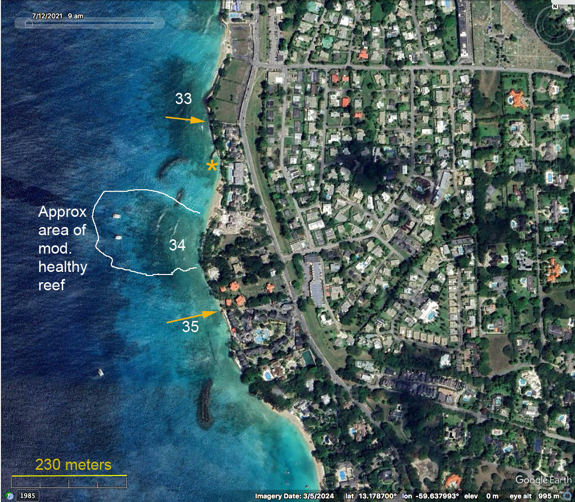
Yellow arrows point to major outfalls in the area of Vauxhall Reef. Yellow asterisk is an area inshore from the large breakwater where there is some smothering by fine sediment. It seems possible that the large breakwater plays some role in deflecting movement of materials from the major outflow just to the north away from Vauxhall Reef; the reef lying immediately north of the large breakwater is highly degraded.
UPDATE Apr 3, 2026 A recent report by UWI/CERMES authors including Robin Mahon provides clear evidence that the health of fringing reefs on the west coast of Barbados is strongly impacted, negatively, by outflows from watersheds, see:
| Barbados’ west coast fringing reefs: a broad-scale assessment of their ecological condition and impacting environment (2009-2012). by S. Connell, R. Mahon and H. A. Oxenford, 2026. Centre for Resource Management and Environmental Studies, The University of the West Indies, Cave Hill Campus, Barbados. CERMES Technical Report No 112, 45 pp. |
The Vauxhall Reef – identified in that report as the combined MPA Reefs 34 and 35 – is ranked 2nd for “Visual Health Index” among 43 Fringing Reefs on the West Coast (Vauxhall VHI 3.61; range for all reefs 1-3.75); Vauxhall VHI is the highest of the 6 Fringing Reefs of the MPA.*
*Conell et al. 2026 use different criteria to define an individual fringing reef than applied by Maclean & Oxenford, 2016
Thus the report provides independent support for my conclusion based on visual observations that the Vauxhall Reef – referring to MPA Reef 34 only, and more specifically to an approx. 2 ha area within that reef – is by far the healthiest fringing reef within the MPA.
While the report provides strong evidence that watershed outflows negatively impact Reef Health over the whole suite of fringing reefs, i.e. reefs subject to lower flows are healthier, as I interpret the data, one cannot say that within the MPA, differences in reef health are attributable to differences in watershed outflows (as estimated) between these reefs.
So I believe it remains possible that, as suggested above, local conditions somehow buffer, to some degree, the healthy patch of reef within MPA Reef #34 from the watershed outflows. It’s still just a hypothesis, however. And unfortunately such buffering did not prevent larger scale, external or global factors – Stony Coral Tissue Loss Disease, Extreme Warming, and Extreme physical disturbance associated with Hurricane Beryl – from impacting the reef post-2022.
There is a lot of interesting info. very pertinent to the fringing reefs of Barbados in the CERMES report. The methodology for assessing Reef Health based on -“a non-conventional expert ranking of underwater landscape photographs – will be of special interest to “reef watchers” be they professionals or “citizen scientists”. Certainly it has made me look at my many photos with a different eye, and will likewise impact the photos I take and how I attempt to assess reef health when I get back to Barbados, hopefully in early 2027. – david p, Apr 4, 2026.
Reminder: Illustrative Photos of sediment smothering in the area of outfalls etc to be added.
Page posted Apr 19, 2024