A new interactive map – the Ecological Landscape Analysis Report Finder – conveys a lot of useful information. An updated Forest Development Stage Layer on the Provincial Landscape Viewer appeared to introduce some significant errors for a site I have been monitoring; NRR is working to address such errors.
Nina Newington passed on this info she received recently from Peter Bush (Old-Growth Forest Coordinator, Nova Scotia Department of Natural Resources and Renewables):
– A new provincial ELA update document using 2022 data is available here, Ecological Landscape Analysis Reports | novascotia.ca
– A story map related to our Ecological Landscape Analysis (ELAs): Linking the Landscape to the Woodlot (arcgis.com).
– Also note that, there is a new development stage layer available on the PLV (more defined mature forest and now based on age).
– We updated our OGF Story Map to have a dashboard on the policy, and some new videos:
Old-Growth Forests of Nova Scotia (arcgis.com)
The dashboard highlights that we have added 400 ha Old-growth forest to protection since August 2022
Of note on the webpage Ecological Landscape Analysis Reports | novascotia.ca is a link to an interactive map page, the Ecological Landscape Analysis Report Finder:
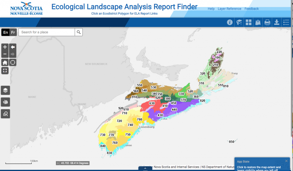
Screen Capture 12Apr2023. Click on image to go to actual map
There is a lot of very useful info. stacked on this page. Click on an Ecodistrict to start exploring.
The Revised Forest Development Class Layer
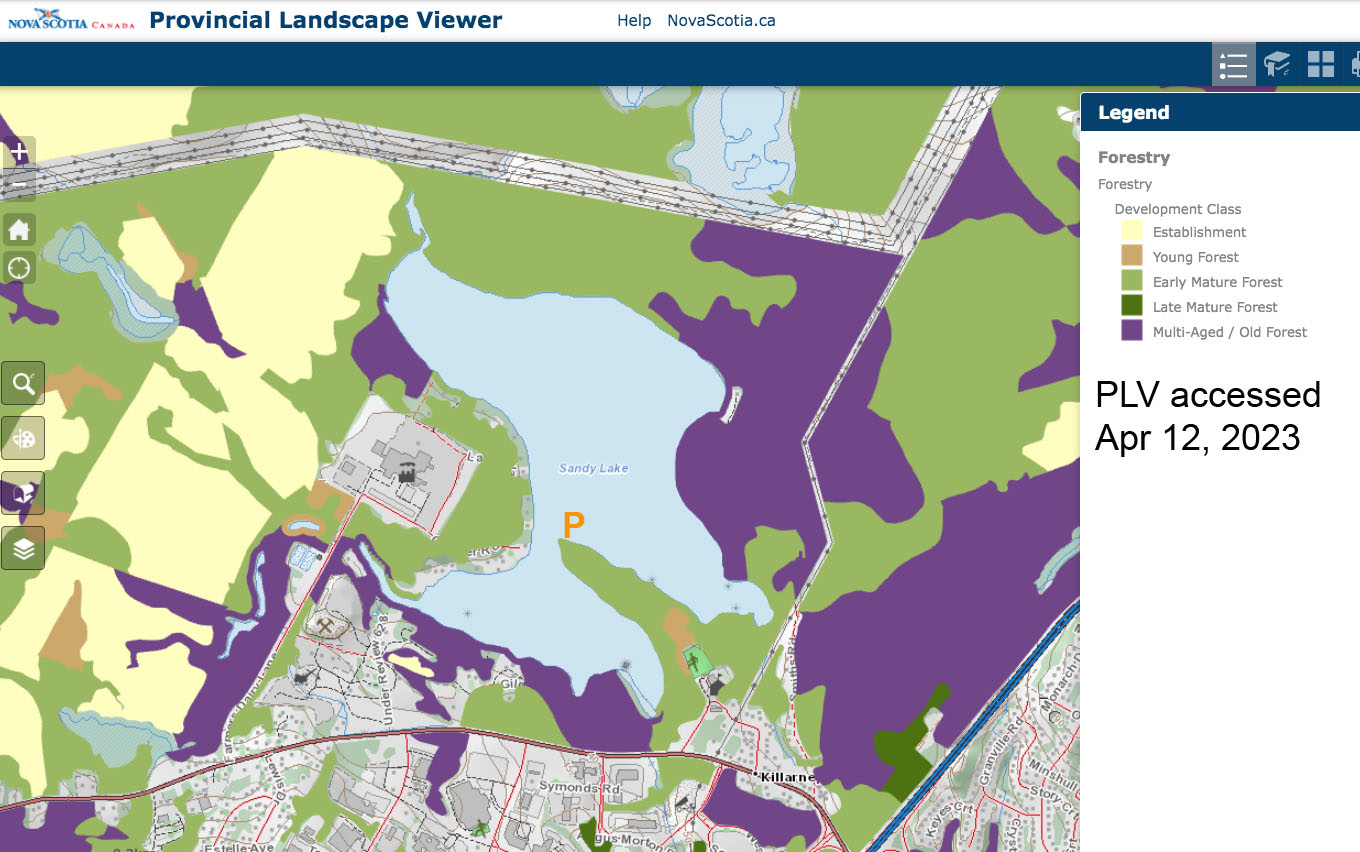
I took particular note of Peter Bush’s comment that “there is a new development stage layer available on the PLV (more defined mature forest and now based on age)”. (PLV refers to the NS Provincial Landscape Viewer.) I have made a lot of use of this layer both in relation to checking out areas proposed for forest harvests (e.g., see Post on NSFN 27Jan2022) and in my own natural history investigations locally (those mostly within Halifax Co.).

Forest section on Sandy Lake & Environs website. Most relevant to this post are the subpages Big Trees and Mature/OG Forest
So I decided to check out the new DCL (Development Stage Layer) for an area I know very well – forest around Sandy Lake in Bedford NS. (View Forest section on the Sandy Lake & Environs website). To my astonishment, the new DCL reclassified some significant areas I knew from ground observations to be Old Mature or Muti-aged/Old Growth and that had been classified as such in the 2017 version of the map; the reclassification now identifies these areas as Early Mature Forest.
So I wrote Peter Bush.
My first question (Apr 12) was to ask how stand age is estimated
Nina N sent a me copy of various updates you informed her about incl. “Also note that, there is a new development stage layer available on the PLV (more defined mature forest and now based on age)”. I am wondering how stand age is estimated. Any info appreciated.
Peter B replied within the same day :
Quick response, Yes estimated age through Photo-interpretation, based on height and site class.
Some explanation in Ela information I sent her. Longer response later in the week.
So I checked the Height layer for the 2017 version, and for the 2023 version and they had not changed significantly. There is no site class layer on the PLV.*
*As I understand it, the “site classes” provide geographically based estimates of “Land Capability” which are given in units of cubic meters of wood per hectare per annum (i.e. the estimated annual growth of trees; the amount of wood that could be harvested ‘sustainably’ if site conditions are maintained and no allowance is made for wildlife requirements); there are different classifications for hardwoods and softwoods (see NS Photo Interpretation Specifications, section 10; and Forest Research Reports 92 – for hardwoods and 22 for softwoods). Relationships between “Site Index” and Tree Height are used in silviculture to estimate tree heights with age or conversely the age of a tree from its height (deYoungCh 6.3). Land Capability info. for NS seems to be publicly available only via Geographic Information Systems)
I then sent this follow-up (Apr 13):
Hi Peter,
I have checked out an area I know well, around Sandy Lake in Bedford, NS.
The revised FDSL (Forest Development Stage Layer) shows a major change from earlier versions that is not reflected on the ground/Please see the attached maps. There is a big shift on the north side of Sandy Lake in the 2023 version compared to the 2017 version, yet there has not been major windfall or any harvesting to account for it. Also, the Tree Height layer and the Seral Stage layers do not show such change.
Where the P on the map is located there is an Old growth hemlock forest >200 yrs of age; it is Id’d as a patch on the 2017 version as Late Mature Forest, but in the 2023, it is identified as Early Mature Forest. It is still there, or at least it was as of last December.
These appear to suggest there are some significant errors in the revised FDSL. Any Comments?
…There are 2 jpg maps attached showing the FDSL 2017 version and 2023 version (yesterday). There are 2 png images which are screen captures yesterday of the forest height and Seral Stage layers. I think you will see the issue quite readily.
-David P
Attachments (Click on images for larger version).
 Forest Development Class Layer Forest Development Class LayerAccessed Dec 10, 2017 |
 Forest Development Class Layer Forest Development Class LayerAccessed Apr 12, 2023 |
 Forest Height Layer accessed Apr12, 2023 |
 Seral Stage Layer Accessed Apr 12, 2023 Seral Stage Layer Accessed Apr 12, 2023 |
Peter B replied that he would like to set up an online meeting to discuss the matter. We (myself, Nina Newington and Peter Bush) held that meeting on April 18th. We had lengthy conversations on a range of topics. On the matter of the apparent errors in the new map layer for Sandy Lake, Peter Bush provided this summary of his response today (Apr 24, 2023):
| Hi Dave,
Thank you for your question. The Development Stage layer are part of series of interpreted GIS layers to support Ecological Landscape Analysis. All of these layers are intended for broad-scale analysis across ecodistricts and the whole province. No decisions related to whether a forest is harvested or put into old-growth forest protection is based on these layers, these types of decisions are only based on ground-based field measurements. The two development layers you are referring are based on two independent forestry inventories. The 2017 Development Layer is based on an inventory (from Halifax County) that used air photos from 1992 and 2003, and the 2023 Development Layer was based on air photos taken in 2017 (for Halifax County). Forest inventories are completed every approximately 10 years by professional air photo interpreters, using previous inventories, new photos, harvest data and other data to make new independent interpretations of over 1 million polygons across Nova Scotia. Since 1992 there have been some changes to the forest inventory process and techniques used, which results in some of changes we see between forest inventories (e.g. starting 2007 photography, the scale of the photographs changed from 1:10,000 to 1:12,500). Development layers are just reclassifications of those independent interpretations. The forest inventory includes a series of attributes determined by the air photo interpreter that we can use to reclassify the forest into other data layers to support broad-scale landscape analysis. One of those attributes is age. Age is not a measured variable, but an estimated one, based on site class and stand height (both independent interpretation calls). The interpreters then use those attributes with a series of graphs (i.e. curves) to estimate age. Better site classes (good growing sites) generally allow trees to grow taller faster. Therefore, higher site class areas will have a lower estimated age for stands that are the same height compared to a lower site class. The two areas you are referencing experience the following changes related the new forest inventory that was used to develop the new independent 2023 Development stage layer.
How does this affect the broad-scale estimation of development stages across the province? On average these commission errors (wrong classification) will average out between inventories. However, as long as height/site is the method of age prediction there in an inherent bias to underestimate age in older stands where height growth is being limited by environmental factors. My initial assessment and based on your observations this layer underestimates some the late-mature and multi-age forests (i.e. some forest displayed as early-mature are likely late-mature on the ground). We will complete some additional analysis to better quantify this estimate of accuracy. In conclusion, the 2023 Development Stage layer is different then previous development stage layers. Development stage layers are not the best geospatial datasets to use for changed detection at a stand-level, especially when looking for subtle changes within the mature classes (early/late mature/multi-aged-old) the inventory would perform better on detecting major changes (mature/establishment). That said Remote sensing using standard formats like Landsat, are likely a better tool for change detect. Historical air photos may also be used for change detection at a stand level. Development stage layer is an independent classification of interpreted forest inventory across the entire province (1 million polygons) which provides the best available tool for landscape analysis about categories of forest ages. The department is committed to improving the forest inventory on a continual bases and will be incorporating new remote sensing (including lidar) into an Enhanced Forest Inventory in the near future. The department will work with the Dr. Mathew Novak at Saint Mary’s University’s Wicked Problems Lab to explore ways to better quantify the commission errors in the Development Stage layer based on ground-truth measurement and ages (including your OGF assessments from Sandy Lake). |
Thx P.B.