
 “Extremely Dangerous” Hurricane Beryl in the Southern Caribbean
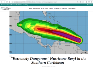
In www.caribjournal.com, by Caribbean Journal Staff – June 30, 2024
“A “major” hurricane is at the edge of the Southern Caribbean right now: Hurricane Beryl. The storm was an “extremely dangerous” Category 4 hurricane when it reached the southeastern Caribbean Monday morning {July 1] , according to the NOAA…
“Right now, a Hurricane Warning is in effect for Barbados, St Vincent and the Grenadines, Grenada and Tobago.”
View List of Barbados hurricanes (1950 to present), on Wikipedia
Update, re Barbados: Ministerial Statement on the passage of Hurricane Beryl July 10, 2024. Some extracts.
” I thank yet again all the essential personnel for the sacrifices they have made and continue to make in the name of national service. Between the night of 30th June and the first 12 hours of 01st July, Barbadians watched and felt the passage of Hurricane Beryl as it tracked towards Barbados from an area to the southeast of the island. As was noted at the time, Beryl was the first hurricane to form in the Atlantic this early in the hurricane season. Clearly our adage of “June too soon, July stand by…” no longer reflects our reality. Not only that, but the fact that Beryl intensified rapidly to a Category 3 by the time the eye passed to the south of Barbados before strengthening to a Category 4 hours after, and then to a Category 5 hurricane on 2nd July 2024, was also a new phenomenon, This clearly highlights the deleterious effects of the climate crisis. Beryl became the earliest Category 5 hurricane in the Atlantic on record and only the second Category 5 hurricane to occur in July after Hurricane Emily in 2005, this according to the National Hurricane Center — and Beryl beat Emily’s record by more than two weeks….
I must say one final thing in relation to the record-breaking Hurricane Beryl. In speaking to fisherfolk and those who make their living from the sea or along the coast, never in living memory has anyone seen sea swells like those which pounded the south coast and decimated much of the west coast. Even infrastructure designed decades ago to withstand severe weather systems proved little match for the destructive swells of Hurricane Beryl. One only need consider the reports of damage to the Bridgetown Port, Bridgetown Fisheries Complex and the boats sheltering there and the damage seen on the south and west coasts to understand the scale of the impact on Barbados and our economy… and with all of this it must be borne in mind that Barbados did not experience the actual hurricane-force winds associated with Beryl…With the hurricane passing to the south of Barbados it meant that the South Coast was particularly exposed. And indeed, in our original assessments, we noted that the coastal area along part of Highway 7 suffered extreme effects of storm surges that left at least two areas impassable. Other areas of the coastline, in the northwest such as Speightstown, also recorded damage from the storm surge… As of July 5th, 2024, a total of 209 boats were affected, directly impacting 560 persons associated with these vessels. At the time of this report 200 boats were recorded as receiving some form of damage to their structure, and 9 boats were confirmed by
surveyors as total losses in the BFC. Prior to the passing of Hurricane Beryl approximately 312 registered boats were active across the island for 2024, based on information from the data collectors, with the Bridgetown Fisheries Complex accounting for 175 of these vessels and Oistins 21. “
Update, Aug 11, 2024:
From www.reliefweb.int July 6, 2024:
On 25 June, the National Hurricane Centre began monitoring a tropical wave with the potential for development that was moving westward. By 28 June, already transformed into Tropical Depression 2 (system AL95), it began to intensify due to atmospheric conditions and officially became Tropical Storm Beryl.
The final conditions for it to become a hurricane occurred on 29 June, making it the first major hurricane of the 2024 Atlantic hurricane season and the earliest Category 4 hurricane to form in recorded history, on 30 June. By 1 July, it became a Category 5 hurricane with maximum sustained winds of 270 km/h.
It is important to remark that Beryl is only the second storm and first hurricane of the season. NOAA forecast predicts an 85% chance of an above-normal season, exceptionally active, with a range of 17 to 25 total named storms. Of those, 8 to 13 are forecast to become hurricanes (winds of 74 mph or higher), including 4 to 7 major hurricanes (category 3, 4 or 5; with winds of 111 mph or higher).This forecast, plus El Niño phenomenon and the climate change increases the risk of stronger storms and puts the Caribbean in high risk. There is a stronger link to climate change driving larger storms and faster intensification, which means more damage and less preparedness time for National Societies.
According to the forecasts, it is likely that before this response is finished, the same countries affected by Beryl will have to respond to other climate-exacerbated shocks and stresses. These will arrive on people already put in more vulnerable positions by this event.
Hurricane Beryl made landfall on 1 July in Grenada and Saint Vincent and the Grenadines as a Category 4, causing three deaths in Grenada and three deaths in Saint Vincent. According to the Prime Minister of Saint Vincent and the Grenadines, 90% of the houses on Union Island have been severely damaged or destroyed. Also, as reported by UN OCHA, an estimated 200,000 people have been affected in both Saint Vincent and the Grenadines and Grenada, representing 100% of the population. According to media reports, approximately 1,752 people in Saint Vincent and the Grenadines are currently in 71 public hurricane shelters. Hundreds of homes in Saint Vincent were also severely affected, including government buildings and several churches.
In Grenada, more than 1,600 people are in shelters, a number that is expected to double. More than 98 per cent of the buildings has been severely affected in the Union, Carriacou and Petit Martinique islands, where most of the health facilities are compromised, as well as the terminal building Carriacou airport, and in general the majority of buildings, including schools and petrol stations, are damaged or destroyed.
Beryl also impacted Barbados on 1 July. The Barbados Red Cross reported on the IFRC GO platform that 208,200 people were affected by the storm, representing almost 74% of the total population. Reports indicate 40 homes with some type of damage, loss of roofs, partial collapse, or damage such as roof leaks. In terms of livelihoods, all boats at the Bridgetown marina sustained damage, and several completely sank due to large waves. According to government, damage assessments will be carried out in the coming days to determine the losses of the fishing industry.
More on impacts on Carriacou, from From www.disasterphilanthropy.org, July 8, 2024:
As Beryl passed through the Caribbean islands of Grenada it caused extensive damage. Beryl made landfall as a strong Category 4 on Carriacou mid-morning on July 1, with winds of 150 mph (Category 5 starts at 157 mph). The majority of the businesses and homes on the islands of Carriacou (population 6,000) and Petite Martinique (population 900) have been destroyed. In addition, the islands have lost hospitals, marinas (and boats), airports and almost all vegetation, including protective mangrove swamps. Communications and electricity are out, and water infrastructure is being assessed.
Carriacou has a population divided between many wealthier people who own second homes on the island and the service industry people who support those homeowners. It is the latter population that will need the most philanthropic support. UN Climate Change Executive Secretary Simon Stiell told CNN, that Carriacou “had experienced a ‘traumatic’ event and will have months of challenges ahead as entire buildings were destroyed with their roofs blown off, with more storms to come.
At least 11 people have died across the Caribbean.
Update Feb 10, 2025
 – On the Grenadian island of Carriacou, even the dead are now climate victims
Natricia Duncan for The Guardian, Dec 3, 2024. “It’s a macabre picture: tombs, headstones and wreaths, lovingly selected by family members, floating into the oblivion of the ocean, and with them the remains of loved ones uprooted from their final resting place. Some are dragged back to land, washed up on beaches on the Grenadian island of Carriacou, transforming the beautiful Caribbean shoreline into a chaotic graveyard…This disturbing reality, says Grenada’s prime minister, Dickon Mitchell, is a poignant example of the gravity of the climate crisis and its impact on his country…The plight of the Tibeau cemetery is being presented as evidence of the worsening crisis facing vulnerable countries in the Caribbean in climate justice proceedings being considered by the international court of justice (ICJ). The case, which opened on Monday, seeks clarification on what states can be held liable for in relation to climate change.