 FireSmart Canada
“The goals for FireSmart Canada are twofold: to improve communication with stakeholders; and to organize programs and assets into a logical, manageable structure based on three pillars – homeowners, neighbourhoods and communities.”
View History (the text is also posted here).
“FireSmart is a registered trademark of Partners in Protection Association” (From https://firesmartcanada.ca/legal-trademarks/)*
| From About Fire Smart
“FireSmart™ Canada is a national program that helps Canadians increase neighborhood resilience to wildfire and minimize its negative impacts. It was founded over 20 years ago to address common concerns about wildfire in the wildland urban interface.” “Everyone can be FireSmart How can you get started?
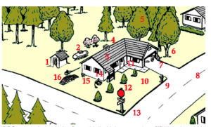
“It all starts with where you live. Research has shown that homes and their surrounding areas are particularly vulnerable to wildfire, which is why FireSmart principles focus on specific actions residents can implement in those areas, also known as the Home Ignition Zone.” |
Wildfire-Ready: Practical Guidance to Strengthen the Resilience of Canadian Homes and Communities
by Cheryl Evans, Dr. Anabela Bonada and Dr. Blair Feltmate of University of Waterloo’s Intact Centre on Climate Adaptation, released Dec 18, 2023. View Press Release. “The report presents a user-friendly synthesis of best practice guidance developed primarily by the National Research Council of Canada, and FireSmartTM Canada, a national program operated by the Canadian Interagency Forest Fire Centre that has been helping communities improve wildfire resilience for 30 years.”
From NS FireSmart
Page on Nova Scotia Natural resources website/ “Just 10 m of defensible space may save your Home!
(Defensible space is an area around a structure where fuels and vegetation are treated, cleared or reduced to slow the spread of wildfire towards the structure)”
——-
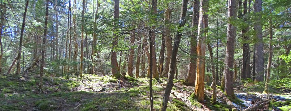
Reducing Fire Risk on Your Forest Property
By Max Bennett et al.. 2010. A Pacific Northwest Extension Publication, Oregon State University • University of Idaho • Washington State University PNW 618 • October 2010. Comprehensive.
Contents:
Chapter 1: Fire behavior risks
Chapters 2 and 3: Principles of fire-resistant forests and Fuel reduction methods
Chapter 4: Firebreaks and shaded fuelbreaks
Chapter 5: Roads and access considerations
Chapter 6: Water sources
Chapter 7: Case history: The Epstein property
Chapters 8 and 9: Integrating fuel reduction with other objectives and Adding fire management to your stewardship plan
Chapter 10: Working with your neighbors
Appendix A: Laws
Appendix B: Effects of topography, weather, and fuel
Appendix C: Additional case studies
Modeling fire susceptibility to delineate wildland-urban interface for municipal-scale risk management
Whitman, E., Rapaport, E., and Sherren, K. 2013. Environ Manag 53:1427–1439.
Current and future wildfire risk in the peri-urban acadian Forest region.
Whitman, E. 2013. Master of Environmental Studies thesis, Dalhousie University.
Ellen Whitman and colleagues applied a spatially oriented fire modeling approach to examine “Future Wildfire Risk in the HRM Wildland-Urban Interface Under Climate Change” and “Urban Forests And Hazard Management: Trade-Offs Between Wildfire Risk And Benefits From Trees In The HRM Wildland-Urban Interface” Spryfield and Beaver Bank were used as case study areas.
Exploring the Widlland-Urban Interface in Halifax NS: Mapping the fire risk in the Eastern Chebucto Peninsula Backlands
ESRI Story Map by Sascha Mosky 2021. As a Master of Planning student at Dalhousie University, Sascha examined fire risk in the Eastern Chebucto Peninsula Backlands. Using civic address point data, Sasha created a 4-kilometer buffer around all homes in the backlands. Then, using Ecological Land Classification data, Sasha classified the various ecosystem types found within the backlands according to their relative fire risk. The findings, which showcase the fire risk for homes across the backlands, are displayed in an ESRI Story Map. prepared for Dalhousie University’s Forest Ecology course (taught by Dr. Alana Westwood).
Osoyoos Indian Band Works to Reduce Wildfire Risk to the Community
Forest Enhancement Society of BC, Oct 11, 2023.
New rules to protect homes from wildfire ignite controversy
By Laurel Demkovich for Oregon Capital Chronicle, October 30, 2023