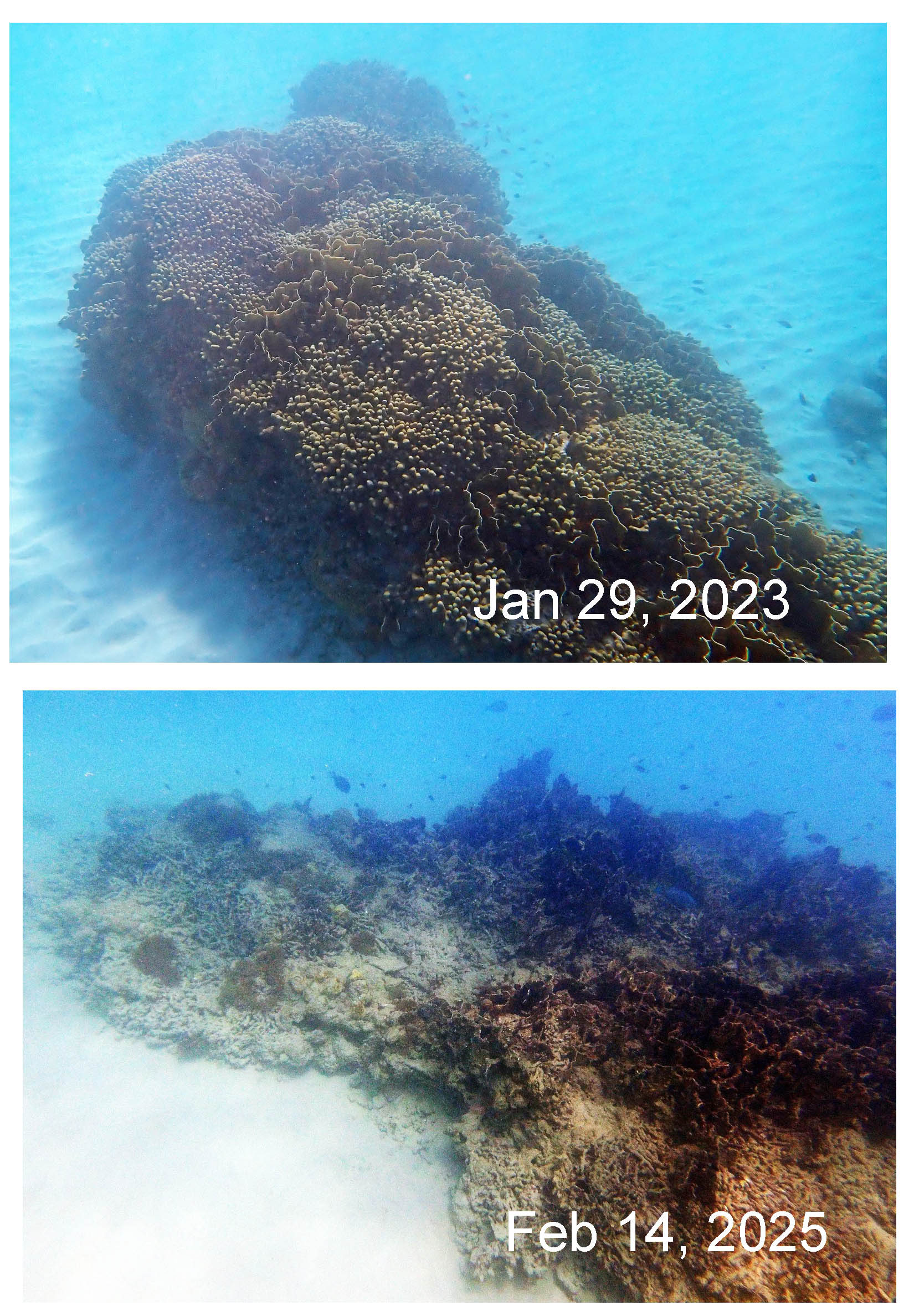
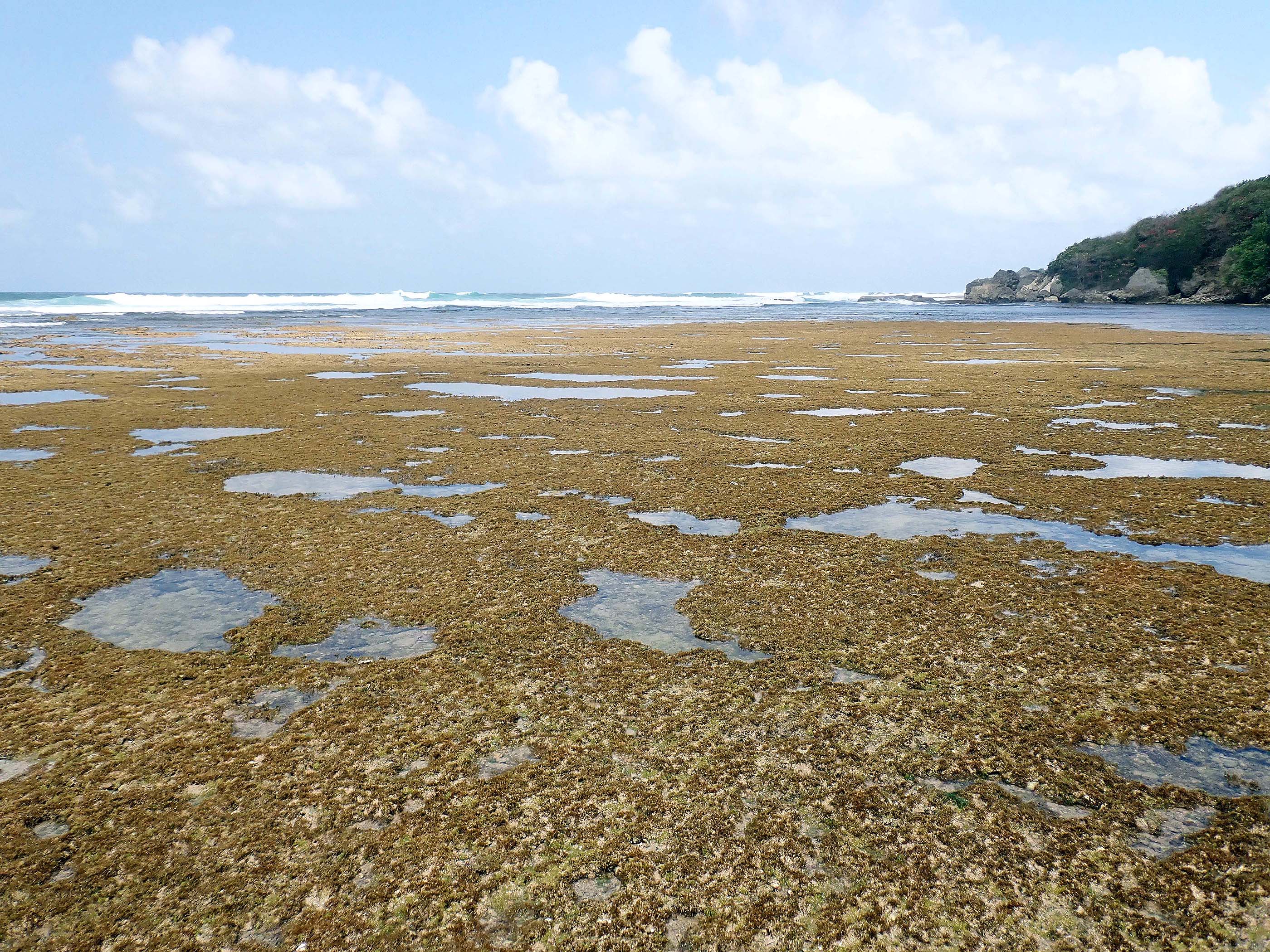
“Extremely Dangerous” Hurricane Beryl in the Southern Caribbean
In www.caribjournal.com, by Caribbean Journal Staff – June 30, 2024
“A “major” hurricane is at the edge of the Southern Caribbean right now: Hurricane Beryl. The storm was an “extremely dangerous” Category 4 hurricane when it reached the southeastern Caribbean Monday morning {July 1] , according to the NOAA…
“Right now, a Hurricane Warning is in effect for Barbados, St Vincent and the Grenadines, Grenada and Tobago.”
View List of Barbados hurricanes (1950 to present), on Wikipedia
Update, re Barbados: Ministerial Statement on the passage of Hurricane Beryl July 10, 2024. Some extracts.
” I thank yet again all the essential personnel for the sacrifices they have made and continue to make in the name of national service. Between the night of 30th June and the first 12 hours of 01st July, Barbadians watched and felt the passage of Hurricane Beryl as it tracked towards Barbados from an area to the southeast of the island. As was noted at the time, Beryl was the first hurricane to form in the Atlantic this early in the hurricane season. Clearly our adage of “June too soon, July stand by…” no longer reflects our reality. Not only that, but the fact that Beryl intensified rapidly to a Category 3 by the time the eye passed to the south of Barbados before strengthening to a Category 4 hours after, and then to a Category 5 hurricane on 2nd July 2024, was also a new phenomenon, This clearly highlights the deleterious effects of the climate crisis. Beryl became the earliest Category 5 hurricane in the Atlantic on record and only the second Category 5 hurricane to occur in July after Hurricane Emily in 2005, this according to the National Hurricane Center — and Beryl beat Emily’s record by more than two weeks….
I must say one final thing in relation to the record-breaking Hurricane Beryl. In speaking to fisherfolk and those who make their living from the sea or along the coast, never in living memory has anyone seen sea swells like those which pounded the south coast and decimated much of the west coast. Even infrastructure designed decades ago to withstand severe weather systems proved little match for the destructive swells of Hurricane Beryl. One only need consider the reports of damage to the Bridgetown Port, Bridgetown Fisheries Complex and the boats sheltering there and the damage seen on the south and west coasts to understand the scale of the impact on Barbados and our economy… and with all of this it must be borne in mind that Barbados did not experience the actual hurricane-force winds associated with Beryl…With the hurricane passing to the south of Barbados it meant that the South Coast was particularly exposed. And indeed, in our original assessments, we noted that the coastal area along part of Highway 7 suffered extreme effects of storm surges that left at least two areas impassable. Other areas of the coastline, in the northwest such as Speightstown, also recorded damage from the storm surge… As of July 5th, 2024, a total of 209 boats were affected, directly impacting 560 persons associated with these vessels. At the time of this report 200 boats were recorded as receiving some form of damage to their structure, and 9 boats were confirmed by
surveyors as total losses in the BFC. Prior to the passing of Hurricane Beryl approximately 312 registered boats were active across the island for 2024, based on information from the data collectors, with the Bridgetown Fisheries Complex accounting for 175 of these vessels and Oistins 21. “
Update, Aug 11, 2024:
From www.reliefweb.int July 6, 2024:
On 25 June, the National Hurricane Centre began monitoring a tropical wave with the potential for development that was moving westward. By 28 June, already transformed into Tropical Depression 2 (system AL95), it began to intensify due to atmospheric conditions and officially became Tropical Storm Beryl.
The final conditions for it to become a hurricane occurred on 29 June, making it the first major hurricane of the 2024 Atlantic hurricane season and the earliest Category 4 hurricane to form in recorded history, on 30 June. By 1 July, it became a Category 5 hurricane with maximum sustained winds of 270 km/h.
Continue reading →