
Calcium Carbonate Budget of a Fringing Reef on the West Coast of Barbados. Part I—Zonation and Productivity
c. W. Stearn, T. P. Scoffin, and W. Martindale. Bulletin of Marine Science, Volume 27, Number 3, July 1977, pp. 479-510(32)
ABSTRACT
A near-shore dominantly coral-covered area on the west coast of Barbados was surveyed from boats and by diving and a marked correlation between the bathymetry and ecological zonation was apparent. An isolated fringing reef within this surveyed area was selected for budget analyses. The proportion of the substrate covered by dead coral, erustose coralline algae, sand, rubble, and living corals (Porites porites, Porites as/reoides, MOll((lstrea aI/IIl/la ris, M. cavemosa, Mi/Jepora spp., Madracis mirabi/is, Sideras/rea
siderea, Agaricia agarici/es, Favia jragu/11) was determined by measurements along six roped transects. The rocky substrate area was calculated from vertical aerial photographs to give the planimetric area, then this figure was modified by relief factors to take into account the irregular reef surface. The macro-relief factor was determined with ropes and detailed underwater mapping, the micro-relief factor determined using weighted string and modelling clay. The areal coverage in m” for each coral present in greater than 1% proportional abundance and for the coralline algae was then calculated. The rate of growth of corals was determined either by using X-radiographs of thin slabs cut through axial regions of corals to reveal seasonal banding or by staining with Alizarin red-So The rate of growth of crustose coralline algae was obtained from measurements made on planted artificial substrates. Once the bulk density of the corals was calculatcd from simple water-displacement experiments, then the CaCO” productivity in gm/m”/year could be calculated for each coral. The overall CaCO” productivity of the reef was found to be 15 kg CaCO”jm” planimetric area per year.
Partial screen capture
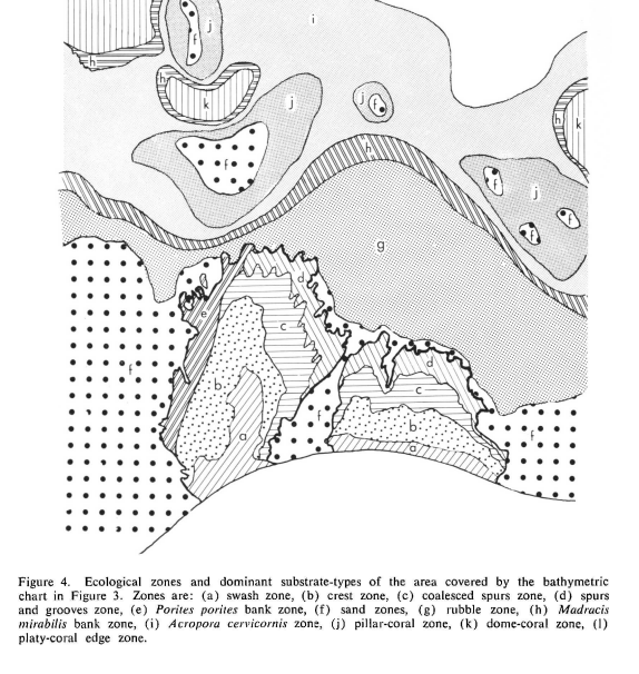
The major ecological zones were mapped (Fig. 4) on the same scale as the bathymetric chart and a comparison of Figures 3 and 4 reveals a marked correlation between local bathymetry and dominant coral population. The characteristics of each zone mapped in Figure 4 are described below. Only zones a, b, c, d, and e are present on the fringing reef.
(a) Swash Zone.-A narrow zone 20 to 30 m wide exists at the shore side of the fringing reefs. Here the small waves break and move sand that in places scours the few prominent
rocks. The depth at low tide is from 0 to 1 m. The region is about 50% mobile sand and 50% dead coral rock (Fig. 6) which is normally infested with filamentous algae which are grazed by Diadema sea urchins. Parts of the seaward edge of this zone support a cover of the colonial anemone, Palythoa mamillosa.
(b) Crest Zone.-The crest of the fringing reef extends from the seaward side of the swash out to sea for about 40 m. It is emerged in places at extreme low tides but is normally at about 1 m depth at low water. The surface is exceedingly irregular being made of small pinnacles of coralline algae (predominantly Porolithon) coating the remains of coral skeletons (Fig. 7). Few corals now live in this zone though the small coral Favia tragl/m is more abundant here than in any other zone on the reef (Fig. 20). The corals Porites porites and Porites astreoides occur in small numbers. In the crest zone a relief of about 1 m is developed between the elevated rocky knobs and the irregular channels and hollows with thin sand covering.
(c) Coalesced Spurs Zone.-The crest zone gives way seaward to a zone of mixed corals. The dominant species are Porites porites, Porites astreoides, Agaricia agaricites, Montastrea annularis, Montastrea cavernosa, Siderastrea siderea, Favia tragum, Millepora squarrosa, Millepora complanata, and Madracis mirabilis (Figs. 8 and 20). The depth ranges from 1 m to about 2 m at low water on the tops of the knobs of coral. The relief between the uppermost corals and sand filled channels reaches 2 m. The coral coverage is uniform over the tops and sides of prominences where the living in-situ fauna represents about 50% of the total rock surface. The remainder is covered mainly by coralline algae (Porolithon and Neogoniolithon with lesser amounts of Lithophyllum and Mesophylfum) or dead coral skeleton. In this zone the sand channels are irregular and sinuous whereas further out to sea they are parallel and at right angles to the shore and the wave fronts.
(d) Spur and Groove Zone.-The seaward front of the fringing reefs normally have aspur and groove configuration. The tops of the spurs range from 1 m to 3 m depth and the sand in the grooves is at about 3 m water-depth on the shoreward side and 5 m depth at their openings. The spurs are from 3 m to 10 m wide, the grooves have the same range in width, widening to seaward at the expense of the spurs. At the seaward front of the spurs small isolated knobs of corals are common (Fig. 19). The spurs have a high proportion of living corals on their tops and sides. The tops of spurs are populated chiefly by Porites porites
colonies but Porites astreoides, Montastrea annularis, M. cavernosa, Agaricia agaricites, Madracis mirabilis, Siderastrea siderea, Millepora complanata, and M. squarrosa, are
all common (Figs. 9 and 20). The following corals are also present but constitute less than 1% of total living coral area:
Diploria strigosa, D. labyrinthiformis, Dendrogyra cylindrus, Acropora palmata, Favia
tragum, Eusmilia tastigiata, and Mycetophyllia sp. The sides and seaward fronts
of the spurs are commonly flanked by shingle-like growth forms of Montastrea annularis (Figs. 5 and 10). The isolated knobs beyond the front of the spurs commonly consist of one large massive colony of Montastrea, Siderastrea, or Diploria.
(e) Porites porites Bank Zone.-Commonly the tops of spurs are densely populated with branching colonies of Porites porites but these areas are not large enough to warrant
description as separate zones except on the south side of Southern Bellairs fringing reef where an extensive shallow (3 m) bank of this coral occurs (Fig. 11), with dead broken branches accumulating in small hollows.
Sand Zone.-Loose particulate sediment, normally with no cover of vegetation, accumulates along the beaches and near-shore areas around the fringing reefs (Fig. 4).
Clean fine sand and silt also occur in the central areas of local depressions (Fig. 4) in the shelf and barrier areas offshore from Holetown River. Sand in the near-shore areas is commonly rippled and supports a large population of the sand dollar echinoids.
Rubble Zone.-On the seaward extension of the shelf beyond the front of the fringing
reef is a broad flat zone of rubble consisting of fragments of Acropora cervicornis. Isolated knobs of living corals are dotted over this area, the dominant species is Diploria strigosa (Fig. 12). This zone extends roughly from 6 m to 12 m depth. Diadema abounds on the rubble.
Madracis mirabilis Bank Zone.-A 20 mwide zone dominated by colonies of the thinly branched coral Madracis mirabilis is normally found at a depth of about 16 m (Fig. 13). In the vicinity of shallow banks and deep depressions just seaward of Bellairs reefs the Madracis zone separates the deeper water Acropora cervicornis zone from the shallower dome-coral bank zone.
Acropora cervicornis Zone.-Spindley branched Acropora cervicornis colonies form a zone of low relief up to 200 m wide in water about 16 m to 20 m deep (Fig. 14).
Mushroom-coral Zone.-From 20 m down to about 30 m is a characteristic population
of massive corals which line the sloping walls of]ocal depressions. Species include
Diploria strigosa, Agaricia sp., Siderastrea sp., Montastrea annularis, Meandrina sp.,
Mycetophyllia sp., Colpophyllia sp., Manicina sp., Montastrea cavernosa, Eusmillia
fastigiata, and Madrads sp. Many of the massive corals develop a mushroom shape
here with broad living surfaces well raised above the fine sediment that surrounds their
bases (Fig. 15).
Dome-coral Bank Zone.-Between about 400 m and 600 m offshore isolated shallow
banks (a dissected extension of the west coast first barrier) ] 2 m to ] 4 m deep have a rich cover of massive corals with uniform relief of about 20 em-50 em separated by a thin cover of sand and rubble. The dominant corals are Diploria strigosa, Diploria labyrinthiformis, Montastrea annularis, M. cavernosa, Siderastrea siderea, Manicina sp., Colpophyllia sp., Dichocoenia sp., Millepora complanata, and M. alcicornis (Fig. 16) . Large sponges, X estospongia and Verongia sp., and alcyonarians are also common. Some of the massive corals grow to 7 m diameter but unlike the corals of the mushroom-coral zone, these corals have living tissue around their skeletons down close to sediment level.
Platy-coral, Edge Zone.-About 600 m from the beach beyond the banks and Acropora cervicornis zone the seaward slope steepens. This zone is populated by broad platy growth forms chiefly of Diploria strigosa, Montastrea annularis, and Agaricia sp. (Fig. 17). In places, at depths beyond 30 m, the coral population is sparse with sponges and antipatharians increasing in
abundance on the muddy seaward slope (Fig. 18).
The physiographic features and coral populations of this small near-shore survey area are roughly similar to those of other Caribbean reefs (Lewis, 1960; Gareau, 1959; Newell and Rigby, 1957; Adams, 1968). No lagoonal area can be ascribed to the Northern Bellairs Reef and the narrow width on this reef between the crest and the shore does not allow the development of a distinct reef flat zone. The major difference
between the living Barbados reefs and other large Caribbean reefs is the marked rarity of Acropora palmata in Barbados.