Home | Why Protect | Photos | View Plane
Ecological and Wilderness Recreational Values of the "Cranberry Lake Lands"
CONFIDENTIAL
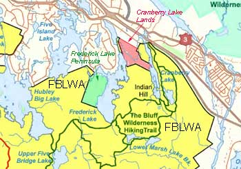
"Cranberry Lakes Lands" refers to two partially adjacent privately properties ( "Property A" & "Property B") lying between Cranberry Lake and Frederick Lake on the Chebucto Peninsula. Lands to the north and to the south are in the Five Bridge Lakes Wilderness Area (FBLWA).
We suggest that the Cranberry Lakes Lands should be included in the Five Bridge Lakes Wilderness Area to protect assets that are highly complementary to those of the existing lands of the FBLWA:
- Integrity of the view plane from The Bluff Wilderness Hiking Trail and Cranberry Lake
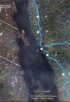
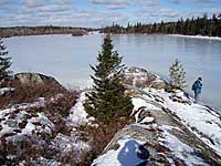
Property A abuts on Cranberry Lake with protected lands of the FBLWA to the north and the south. It includes a small peninsula that juts out into Cranberry Lake, and approximately 130 meters of shoreline to the south of the peninsula. (Total shoreline including the peninsula is ca. 329 m, 175 m via a straight canoe route.) Hikers entering The Bluff Trail begin to get a view of the headlands of Property A as the trail goes over the "whale back" (Site A at right), a high linear granitic outcrop about 700 m from the trailhead. They get a full view of the Property A frontage at the Pot Lake junction (Site C). Hikers often pause at that site before proceeding on the upper or lower leg of the Pot Lake Loop. We have placed a map sign, a guest book and our trail dedication sign at this site. It's also the point where hikers staying on the trail can first stand on the Lakeshore. As hikers move further along the lower branch of the Pot Lake Loop and climb upwards, a large erratic (the "rockingstone", Site E) provides another popular stopping point, and affords a southerly view of the Property A headlands.
Cranberry Lake is highly valued by canoers, kayakers and people traversing the ice in winter. Dusan Soudek of Canoe Kayak Nova Scotia comments:
Cranberry Lake is one of the most scenic lakes on the Chebucto Peninsula. The peninsula contains many fine lakes, but few can match the rugged and varied shoreline of Cranberry Lake for its aesthetic value.
Thus protection would ensure that the vista as visitors look across the lake from The Bluff Trail, or canoe or kayak on the lake, or hike or ski on it in winter, remains wild in nature. This would be in keeping with an important purpose of Nova Scotias Wilderness Areas Protection Act, i.e. "to protect and provide opportunities for scientific research, environmental education and wilderness recreation", and also with the message on the Dedication Sign for The Bluff Trail:
On behalf of all the wild things that make this land their home and with reverence for the First People who preserved this land before us, we dedicate The Bluff Wilderness Hiking Trail to wilderness preservation. We do this in trust that we can learn its deep beauty, in trust that we can understand and delight in the wildness in ourselves that we share with the rocks, earth, water, and teeming life and spirits that surround us, and in trust that we will work together to protect this sacred heritage.
Because of its proximity to our largest population centre, The Bluff Trail is an important wilderness recreation and education asset. The Pot Lake Loop is the most frequented part of the trail, hence we see protection of Property A as vital to these roles.
See View Plane Photos
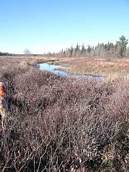
- Wetlands
Properties A & B together encompass a large (ca. 17 ha) and critical part of the largest set of contiguous wetlands in the area. They are diverse wetlands, different portions being classified by NSDNR as bog or fen, fen, swamp and marsh. As well as being important for wildlife, the wetlands border the stream known as Cranberry Run that follows a circuitous route from Cranberry Lake to Black Point Lake, thus they are likely important for maintaining water quality in the upper part of the Woodens River Watershed, e.g., by filtering materials emanating from highway 103. (This watershed is one of four major watersheds which lie partially in the FBLWA.) A portion of the wetland area has been known traditionally as the Cranberry Bog, possibly related to use by early settlers and possibly aboriginal peoples.
See wetland maps
See Photos of wetlands
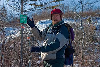
- Canoe portage, winter hiking route & Cranberry Run as a navigable waterway
Canoe Kayak Nova Scotia regularly monitors a 1 km portage route which runs from Cranberry Lake to Frederick Lake along the border between Properties A & B and the crown land, now protected, to the south. At a few points, it crosses portions of the private land. It is one of a set of lakes and portages providing a canoe route from the trailhead of The Bluff Wilderness Hiking Trail through the Chebucto Peninsula to to the Nine Mile and Scotts River waterways and thence to the ocean, a valuable asset to the entire FBLWA. In winter, the same portage route is used as part of the "Cranberry Lake - Frederick Lake - Black Point Lake - BLT Rail Trail Winter Loop". Dusan Soudek comments:
The Crown/private boundary between the two lakes is shaped like a hockey stick, with the obtuse angle apex being at the Crown boundary marker on the wooded peninsula jutting into Cranberry Bog. The portage deviates from the boundary at both lake ends, as it avoids vertical ledges and lake shoreline that is unsuitable for landing.
This portage is not only essential for navigation of the Woodens River Lake District but it also forms an important part of the Cranberry Lake - Frederick Lake - Black Point Lake - BLT Rail Trail Winter Loop. It can only be done once Lakes are safely frozen, either on snowshoes or wearing ice creepers. I do this loop at least once every winter, and often follow someone else's tracks on the portages.
Dusan notes also that at high water, Cranberry Run is actually a navigable waterway:
There are a few small and short rapids between the long stillwaters. They can be run at high water. The last 100 m or so of the stream, just before it plunges into Black Point Lake, are a bit tricky as the stream meanders very sharply here. One may wish to portage out just before the derelict earthen dam via the well-used Black Point Lake - Frederick Lake portage.
See also:
- Other features
- Other habitat features of note include the high barrens with outstanding views, oak woodlands, and approximately 300 m of lake frontage on Frederick Lake. (Collectievly, Property B, the Frederick Lake Peninusula (approx 1200 m of Lake frontage) and frontage on FBLWA land (ca. 3.2 km) make up ca. 3/4 of the shoreline of Frederick Lake (approx 6.2 km) with the remaining 1,5 km from Cambrian Cove up in relatively low density residential holdings.
-
Protection would fill a gap in the FBLWA on the west side of Cranberry Lake. While there is no official trail now, there has been ATV activity in the past, and hikers frequently go down the west side of the lake, crossing the private lands as they do, to reach the Indian Hill Loop of The Bluff Trail. Even in its unfinished state, it is somewhat easier going and quicker than accessing the Indian Hill Loop via the Pot Lake route. Recognizing that hikers are likely to keep using this route, it may be appropriate to maintain it as part of The Bluff Wilderness Hiking Trail.
- The Cranberry Run Dam: About this feature, Dusan Soudek comments:
The dam is at the very outlet of Cranberry Bog, maybe 50 m from Black Point Lake. Cranberry Run passes here through a gap in the granite ridge that forms the eastern shoreline of Black Point and Frederick lakes. It is on the inland boundary of the narrow enclave of Crown property, now part of the FBLWA, which hosts the portage between these two lakes. I cannot tell whether the dam is on private land or on public land, but in either case it is close to the boundary. The dam is a silent memento of the bygone logging era in the area. It is marked on the 1908 Faribault - Fletcher Geology Map (City of Halifax, Sheet No. 68), but is not shown on the 1865 A F Church map of Halifax County West. The dam had been breached many decades ago, and one can easily canoe through it. It is not easy to photograph, as it is quite overgrown with shrubby vegetation. It can be accessed via a very rough fisherman's trail from the shoreline of Black Point Lake. It is somewhat paradoxical, but people in the wilderness often pay a lot of attention to remains of civilization there. They often stop here to view the remains of the massive earthen dam. It is on the border of the existing Crown enclave and the adjacent private property. Securing the private property for the wilderness area would protect this industrial heritage site.
|