Home | Why Protect | Photos | Panorama
Ecological and Wilderness Recreational Values of the "Frederick Lake Peninsula"
The "Frederick Lake Peninsula" is an undeveloped, privately owned block of land on the west side of Frederick Lake. It borders the Cambrian Cove on its northern face and the Five Bridge Lakes Wilderness Area (FBLWA) on the west and south borders.
The major reasons that we would like to see it included in the FBLWA are:
- Integrity of the View Plane from The Bluff Wilderness Hiking Trail
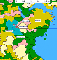
Development of the area would likely involve the barrens, mixed forest and the deciduous forest/drumlin regions on the northern half of the block. 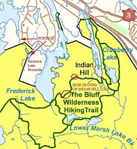
Adapted from NSE Map |
Much or most of this area is visible from high ground sections of the Indian Hill Loop of The Bluff Wilderness Hiking Trail. Thus, development would detract significantly from the wilderness experience on The Bluff Wilderness Hiking Trail, an important asset of the FBLWA. (The trail has been named one of the best eight urban escapes in Canada by the prestigious magazine, Explore: Canada's Outdoor Magazine.)
See View Plane Photos
- Integrity of the Canoe-Portage Route
The private land encompasses a key part of the canoe/portage route between Frederick Lake and Five Island Lake. Altogether, the lakes and portages provide a canoe route from the trailhead of The Bluff Wilderness Hiking Trail through the Chebucto Peninsula to the Nine Mile River system and thence to the ocean, a valuable asset to the entire FBLWPA.
See Portage Photos
- Wetlands & Watershed Integrity
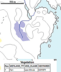
The southern half of the block encompasses approximately half of an eight hectare wetland classified by DNR as a fen (the other half lies within the FBLWA) and a large low-lying, swampy coniferous forest which feeds a stream or streams which flow into Frederick Lake.
Adapted from DNR Maps
Click on images for larger versions |
The Natural Features Map indicates that the fen feeds a stream going into two small waterbodies that are part of the flow from Frederick Lake into Five Island Lake, however, at least the more southerly area of the fen appears to drain into Frederick lake via the coniferous forest area. The conferous forest/swamp appears to collect water over a large area and for the first 50 to 100 m or more, this water moves below the sphagnum cover on the forest floor, then it begins to collect in higher order streams with open water.
The fen and coniferous forest filter atmospheric inputs and are sources of humic materials entering the streams. Thus, the continued integrity of this system is important for maintaining water quality of Frederick lake and the outflow to Five Island Lake, including its brown water nature.
As well, the fen and the coniferous forest swamp are significant wetland features on their own. Overall the vegetation of the fen is more bog-like, with a preponderance of ericaceous vegetation, than fen-like (usually with a preponderance of grasses, sedges, rushes, perhaps leatherleaf, meadowsweet); much of the fen is hummocky and there are scattered small rock outcrops.
The coniferous forest/swamp has old growth features, including fir, black spruce, red maple and yellow birch trees of greater than 12 inches dbh, snags and fallen dead trees. Firs are most numerous overall; the larger trees are likely near the limit of their lifespan. Given the wetland nature of the area, presence of old firs and other species, and proximity to the Atlantic Ocean, it is a potential habitat for rare cyanolichen species. (See Heuristic model for identifying the habitats of Erioderma pedicellatum and other rare cyanolichens in Nova Scotia, Canada.
Robert P. Camerona and Thomas Neily The Bryologist 111(4):650-658. 2008).
See Photos of Fen
See Photos of Coniferous Forest Swamp
- Protected shoreline
The shoreline of the private block amounts to about 1/6th of the shoreline of Frederick Lake; about 1/6th is currently developed (but lightly) and about 2/3 of the shoreline, on the south and east sides of the lake, is in the FBLWA. With inclusion of the private block in the FBLPWA, approximately 5/6th of the lake frontage would be permanently protected.
See Shoreline Photos
- Oak Drumlin
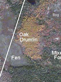
Adapted from Google Maps
Oaks retain their leaves for a period in the fall and we discovered that these oak dominated drumlins stand out in the Oct. 31st 2005 Google Maps and Google Earth satellite imagery of a portion of the Chebucto Peninsula, including the Frederick Peninsula. Ground examination confirmed the presence and abundance of oaks at several such sites. |
A small drumlin (approximately 7 ha) abutting on the fen lies entirely in the private block. Google Map imagery of Oct. 31st, 2005 and ground inspection show it to support an oak dominated forest. Trees are typically 4-6" dbh, there are lots of trees that developed in clusters from stump sprouts and trees appear to be more or less even aged. The largest oaks are single trees of 7-8" dbh. Large snags and fallen dead are generally lacking as are large, old, cut stumps. Thus it is likely that this stand was burnt over, perhaps 30-50 years ago when there were extensive fires in this area. Witch hazel and witherod are common understory tall shrubs. Blueberry, bracken fern, lambkill, huckleberry, teaberry as well as oak seedlings occur on the forest floor. There is a sharp transition to wetter forest dominated by red maple/black spruce with prominent cinnamon fern as you move from the oak dominated drumlin down onto the fen; some larger red maple (16" dbh) occur in this area, likely because they were not severely burnt in the fire that affected the oaks.
The Umlah Hill drumlin we investigated in 2009 supports a multiaged old growth oak forest which apparently escaped fires by virtue of being quite remote and largely surrounded by wetlands. As described in our report on the Umlah stand, that old growth forest stand appears to be wind structured and maintained.
In the continued absence of fires, it seems very likely that the "Frederick Lake Drumlin" and a handful of other drumlins in the FBLWA would develop a mature forest structure and makeup similar to that on Umlah Hill. With climatic warming and possible drying as well, red oak is likely to become more prominent overall. Thus conserving these oak dumlins is worthwhile as they are potential old growth stands and sources of propagules for spread of oaks as climate warms. In the case of tbis particular drumlin, its location next to the fen is also relevant. Development of the drumlin would undoubtedly impact the fen.
See Oak Drumlin Photos
|