APWPS/Discover the Watershed ProjectSurface Waters and Other Features of the Forest CommonsComments by David Patriquin (Professor of Biology, Dalhousie University) Submitted to APWPS August 29, 2007.
1. Background & Objectives
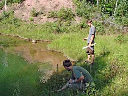
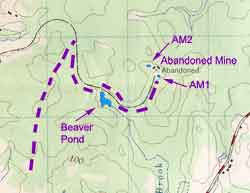
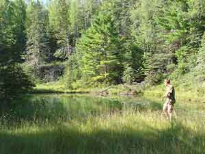
2. General ProcedureThe Forest Commons hike took place on Aug 1, 2007, 2-7 pm. We entered the Forest Commons and made our way to the Abandoned Mine via the Harvey and Wilson Roads and the Old Railway Bed; this route is referred to below as "the trail". On August 27, we walked up the Shaw Brook from the point where it crosses the road just west of Poplar Grove. GPS readings, photographs and video were taken at water bodies and other features of interest. Observations on August 27 included a practical trial of a protocol developed by the Flint River Watershed Coalition for volunteer based stream habitat assessment/monitoring.23. Observations
We did not go off the trail on the Forest Commons hike except briefly at the Beaver Pond and at the Abandoned Mine. SURFACE WATERS
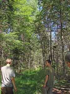
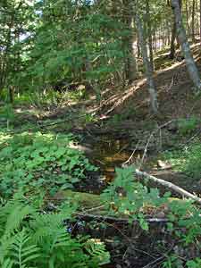
Harvey Road Pond Wilson Road Ponds 1 and 2 Standing water in wheel tracks Stream The Beaver Pond Beaver Pond Dam/Shaw Brook Abandoned Mine Ponds. AM1 was the first pond encountered when we entered the Abandoned Mine area. It appears to drop into deeper water quite sharply. Project personnel said that it never freezes over and called it "The Hot Springs". However it is not particularly hot - one had swum in the pond earlier in the summer and it was icy cold! The water has some cloudiness, possibly associated with fine suspended gypsum and/or sulfur-oxidizing bacteria (growing on hydrogen sulfide and oxygen) and/or phytoplankton. AM2, the second pond, is a smaller pond with shallow, submerged aquatic vegetation visible over most of the pond, pockmarked with open patches that apparently go into deeper water. There were distinct cloudy white patches in these latter areas, again possibly associated with fine suspended gypsum and/or sulfur-oxidizing bacteria and/or phytoplankton. Photograph Shaw Brook below the Forest Commons VEGETATION Trees, Clearcutting Before reaching the railway bed, a stand of tall hemlocks could be seen about 300 meters to the west ("Hemlock Grove"). It has been sold to the gypsum company and will likely be clearcut. There was a stand of large hemlocks on slopes adjacent to a stream approx 1.5 km (10 min. walk) before the Beaver Pond. Hemlocks had been clearcut above that area. Photographs In the region of the Beaver Pond there were some large standing white pines. Project personnel commented that a large number of white pines in that area had been removed by clearcutting within the last 2 years. Photograph There was a lot of balsam fir in the region of the Abandoned Mine. Project personnel said that much of this area had been clearcut/bulldozed within the last 2 years; before that closed forest bordered the narrow ATV trails, making them very attractive. Weedy Vegetation Forest Understory at the Abandoned Mine Three native species cited as characteristic of "plaster rock" by John Erskine3 were observed during the hike.
Also of note: on fir covered slopes at the NW border of the Abandoned Mine there were numerous broad leaved helleborine orchids (Epipactis helleborine). Yellow lady's-slipper orchids were also abundant in the same area. The lady's-slippers were post bloom, some Helleborine orchids had a few flowers, most were post-bloom with ripening fruit. Helleborine is a non-native species, originating in western Europe, Ireland and the U.K. It was first seen in Nova Scotia on in 1985.4 WILDLIFE Frogs, Turtles Mammals 4. DiscussionThere has apparently been extensive clearcutting & bulldozing within the last 2 years on the large blocks of land owned by the gypsum company in the centre of the Forest Commons. Some significant stands of older white pine and hemlock were cut, but much of the timber was presumably fairly low-grade poplar, small birch, black spruce. It appears that the recent clearcutting/bulldozing operations have destroyed a lot of native orchid habitat. Some significant older growth stands remain on the gypsum company holdings that could be clearcut in the near future. It is clear that if this area is to regain and retain its ecological integrity, some sort of selective harvesting scheme would need to be introduced. The comments by the area farmer concerning more extreme fluctuations in water flow in the Shaw Brook following extensive clearcutting in the Forest Commons, and his comments about other source waters for the Shaw Brook deserve follow-up. There were many dead-end culverts, bulldozed patches etc. left after the exploratory drilling operations. It seems that little if any consideration was given during the exploratory drilling operations to protecting the integrity of the Beaver Pond, the largest body of open water in the interior of the Peninsula. The status of the fish population in the pond needs to be investigated, and appropriate protective measures and restocking considered. The frog population appears to be exceptionally large and healthy which contrasts with declines of frog populations over much of the globe. Obviously one factor is a large amount of wetland or quasi-wetland habitat. Another may be the absence of forest spraying and the elevated, upstream position of the Forest Commons in relation to surrounding agricultural land. The status of the frog and reptile populations in the Forest Commons deserve special attention in any environmental reviews of this area. The Abandoned Mine (closed approx. 85 years ago), presents an interesting contrast to the existing (Miller Creek) mine and the proposed extension of that mine west of the Ferry Road. The Abandoned Mine was miniscule in area by comparison and was a much shallower mine (probably less then 30-40 meters), without the massive spill areas characteristic of the current mine. Project personnel said that until the recent bulldozing/exploratory drilling operations, the area of the old mine had been largely grown over and supported closed canopy forest; the nearly closed over trails through that area were especially valued by ATVers. By contrast, the proposed new mine, many fold larger and deeper would have massive direct and indirect environmental impacts and reversion to a more natural state, if any, would be measured in centuries or millennia, rather than decades. SOME HIGHLIGHTS FOR SUSTAINABLE MULTIPLE USE The two ponds in the Abandoned Mine area are interesting features that might be highlighted in sustainable multiple use options for the Forest Commons area. They are visually attractive and interesting with their unusual and contrasting hues, and in regard to the contrasting character of the two ponds. Studies of their depths, the nature of the white cloudiness, oxygen and hydrogen sulfide content, and species of aquatic vegetation and fauna in the ponds would be appropriate. Likewise, there are many other features of the Forest Commons that could be highlighted in sustainable/multiple use options, e.g. the following:
VOLUNTEER MONITORING PROTOCOLS The Flint River Watershed Coalition Stream Habitat Assessment Procedure2, with a little training, is easy to follow yet is quite comprehensive. I suggest it could be adopted as it stands to stream habitat assessment and monitoring by APWPS, however it would be appropriate to seek input from other volunteer organizations on such matters, e.g., the Clean Annopolis River Project. A set of stream flow observations on the Shaw Brook, repeated seasonally, could be instituted quite readily (with volunteers) and could be one means of monitoring effects of changes in management of the Forest Commons on the peninsular water regime. I encourage also the routine and extensive use of digital photography and audio or audio-visual files for documentation purposes. The equipment is now relatively inexpensive.5 Benefits of the digital format include reduced time required for field observations, less dependency on good weather (for recording observations), and easy replication and distribution of data for further processing and other purposes (e.g., training, public education). NOTES 1. From the project proposal: The overall goal of this project [The APWPS Discover the Watershed Project] is to ensure a long-term present needs of farms on the peninsula and to provide economic viability of farming on the peninsula. A watershed achieve this will include the following subsidiary goals: 1) Developing a concept of the watershed we live inThe Avon Peninsula is a unique farming community surrounded by tidal estuaries Windsor, in Hants County, Nova Scotia. It consists of the communities of Avondale, Poplar Grove, Belmont, and Mantua. The peninsula has excellent soil, excellent landscape biodiversity, excellent human resources in farming, and a cultural growing food. Approximately twenty-five square kilometers in area, today has three dairy farms, five beef farms, three certified organic market farms, turkey farm, a nursery, orchards with organic potential, a large commercial horses everywhere. There is considerable interest in market gardening and small-scale valued-added agricultural businesses, including agri-tourism. The eastern part of the peninsula has been deeply impacted by strip-mining for gypsum. However the high, wooded land in the interior of the western part of the peninsula is still relatively intact. It is the heart of the peninsula's watershed, as it is where the headwaters begin, and where most of the wildlife habitat is. Underlying the heartland is one of the most complex "gypsum karst" geological formations on the planet, which gives rise to the fragile hydrology, unique ecology, and special landscape of the gypsum woods. The integrity of the peninsula watershed ties together the community's rural landscape, wells, ponds, streams, wetlands, marshes, tidal rivers, scenic vistas, waterfront, heritage sites, farms, homes, and local economy. Many community residents still refer to the western wooded upland of the watershed as the Commons. Although owned by individual community members, local farmers once managed the Commons collectively. It was valued as a sustainable source of firewood and lumber for local residents. However, with changes in landownership and land use in recent years farmers have become concerned about the impact on the water resources that farmers depend on. Clearcutting in the watershed has been associated with observed unusual fluctuations in stream flows, and farmers wonder whether the watershed is being degraded in the absence of the moderating influence of the trees. Furthermore, strip-mining interests have assembled extensive land in the area and farmers are concerned about the impact of core drilling, blasting and mining operations on streams, ponds, wells, and well casings should mining proceed. Also, farmers are concerned about the impact of flooding and drought associated with climate change. These changes have resulted in a general sense that the future viability of farming on the peninsula cannot be taken for granted, and that there is an urgent need for a proactive response. 2. See Flint River Watershed Coalition Documents: Stream Assessment Standard Operating Procedure | Stream Survey Form Google web page versions: Stream Assessment Standard Operating Procedure | Stream Habitat Data Collection Form 3. Erskine, J. 1976. In Forest and Field. Halifax: Nova Scotia Museum. It seems likley that most or all of the species cited by John Erskine in his delightful Plaster Rock essay (pp 44-52) occur in the Forest Commons: gypsum ragwort, gypsum fleabane, shrubby cinquefoil, American dog-violet. gypsum buttercup, bird's-eye primrose, round-leaved dogwood, soapberry, leatherwood, two-leaved lady's-slipper, ram's-head lady's slipper, yellow lady's slipper and gypsum sedge. 4. Munden, C. 1999. Native Orchids of Nova Scotia. A Field Guide. University College of Cape Breton Press Inc. 5. During the course of the two excursions, we utilized a consumer level GPS unit (cost approx. $175), a consumer level weatherproof digital camera with audio and video recording options/2 GB storage (approx $450), a monopod support (approx. $30), a 2 m calibrated pole, a 50 m reel-type measuring tape (cost $25) and a stopwatech (cost approx. $30) to make and record observations; total cost of equipment: approximately $710. Digitally recorded observations included photographs, comments by participants, photographic images of the GPS readings and data forms and some video. |