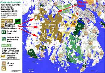
Click on map for larger version. |
The proposed
Chebucto Wilderness Area (CWA) Includes Public Lands bounded by Highways 103 and 333 on the Chebucto Peninsula as shown in brown on the map.
The Chebucto Wilderness Area is a mosaic of lakes, streams, ponds, wetlands (bogs, fens,
marshes), granite barrens, and mixed and evergreen forest. It includes the upper
part of the Woodens River watershed, major portions of the Nine Mile River watershed, the Blind Bay watershed, a lower part of the Prospect Bay watershed, as well
as several smaller watersheds and numerous small to medium_sized wetlands.
Protection of this area under the Wilderness Areas Protection Act is being sought by the Chebucto Wilderness Coalition, signed onto by WRWEO, The Five Bridges Wilderness Heritage Trust, the St. Margaret's Bay Stewardship Association, the BLT Rails to Trails Association, the Safety Minded ATV Club, the Resource Opportunities Centre, and over 30 other community organizations around the Chebucto Peninsula.
|