wrweo.caEmergency Helicopter Landing Sites
on The Bluff Wilderness Hiking Trail
Preliminary Survey
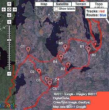
The following sites have been identifed as potential emergency helicopter landing sites on The Bluff Trail. The survey was conducted in the fall of 2010. The sites have around a 100ft diameter clearance and not many foreign object that could damage the engines or rotors. They would have to be verified as acceptable by the search and rescue team.
Large sections of The Bluff Trail appear not suitable as landing sites because of rocks, or swampy conditions or closed forest.
The B series are on the second (Indian Hill) Loop and include 2 sites on the section that is common to both Loops 2 and 3 (Indian Hill and Bluff Loops).
The C series are on the 3.2 km section common to the 3rd Loop (Bluff Loop) and the 4th Loop (Hay Marsh Loop).
| No. | Geographic Coordinates | UTM Coordinates* |
| B1 | 44.640833
-63.766111 | 0439243
4943338 |
| B2. | 44.640278
-63.765556 | 0439286
4943276 |
| B3 | 44.633333
-63.778056 | 0438287
4942514 |
| B4 | 44.636944
-63.7825 | 0437939
4942919 |
| B5 | 44.641389
-63.78 | 0438142
4943410 |
| C1 | 44.640334
-63.80307 | 0436311
4943311 |
| C2 | 44.630640
-63.79639 | 0436830
4942229 |
| C3 | 44.627073
-63.79142 | 0437220
4941829 |
| C4 | 44.626168
-63.78956 | 0437367
4941727 |
| C5 | 44.625474
-63.78975 | 0437351
4941650 |
*Zone 20, N Hemisphere
| 
See Maps.GPX page for detailed Trail Maps |
|