Water Powered Mills on the Coastal Area of the Bay of Fundy’s Chignecto Peninsula:
A search for remnants of water powered mills that once operated on the estuaries of Western Cumberland County, Nova Scotia, Canada.
By Kerr Canning
Web Link for Presentation
www.http://www.versicolor.ca/kerr/anew/2015_TIMS_Symposium
Each photograph is a thumbnail link to a larger version of the image. Simply place the cursor over a photograph and click.
Geographical Location of the Upper Bay of Fundy’s Chignecto Peninsula

Fig.1:The Chignecto Peninsula and Cumberland County are both located in Northern Nova Scotia, Canada. The Apple River Mill, where
I do much of my research, is located on the western
tip of the Chignecto Peninsula and the latitude of the community of Apple River is 45.4606° N. It is interesting that the latitude of Sibiu, Romania,
the site of the 2015 TIMS Symposium, is 45.7928° N.
|

Fig.2:The Chignecto Peninsula is approximately the triangular shaped western portion of Cumberland County and Colchester County.These counties are shown
on the map above.
|

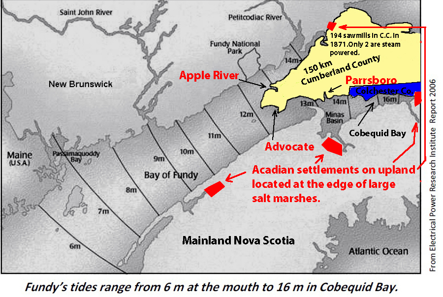
Fig.3:The above map shows the so-called Tidal Amplitude in the Bay of Fundy. Notice that the highest tides occur along the coast of the Chignecto
Peninsula.The map also shows the location of the major Acadian Settlements.
|
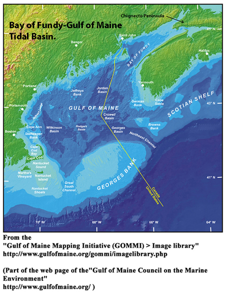
Fig.4:The Bay of Fundy has a natural
period of oscillation close to he period of oscillation of
the Atlantic Ocean’s dominant lunar tidal pulse. When this
pulse enters the Gulf of Maine, a large back and forth tidal oscillation is setup in the Bay of Fundy-Gulf of Maine Basin.
|
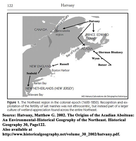
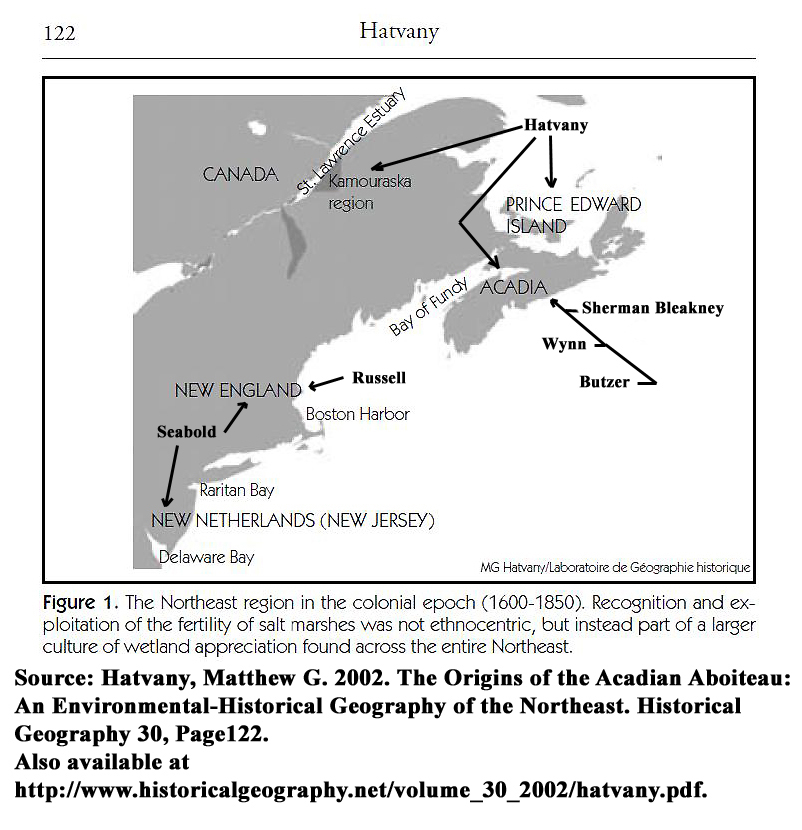
Fig.5:The area between the St. Lawrence River south to the northern edge of New Jersey is called glaciated coast (Sebold 1992, Chapter 2) and
the salt marshes on this coast were formed over the last six thousand years (Amos, 1978, P 965-981,Atlantic Geoscience Society 2001 and Gulf of
Maine Council on the Marine Enviroment. 2008).
|
Water Mills on the Coast of the Chignecto Peninsula:
Types of water powered mills found on the Peninsula.
The Chignecto Peninsula is a heavily forested area and as all of the forests of Nova Scotia, the Chignecto Peninsula is located in the so-called
Acadian Forest Region, , a geographical region
comprising all the Maritime Provinces, as well as the US states: New York, New Hampshire, Vermont and Maine. This type of forest region is
a
Mixture of hardwood and softwood trees containing 32
native tree species; many of these species have a commercial value. It is not surprising that the majority of the water powered mills built on the Peninsula were
designed to manufacture lumber. Grist mills as well as other types of mills were constructed to meet the needs of the local communities.
Common factors used to that determined the mill location.
The process for determining the mill site for
each water powered mill on the coast of the Chignecto Peninsula was
influenced by certain common factors.These include the natural features of the surface of the peninsula, the placement of hamlets,
villages, and towns as well as the ownership of land in these settlements. Also included are seasonal effects such as winter ice and summer
droughts, the mill owner’s range of skills, and the requirement that mill builders place permanent dams on streams in such a way
that there is adequate means for the passage of fish and for others to use the streams for lawful purposes.
Knowledge of these factors is necessary
to understand the history of water powered mills built on the
shoreline of this Peninsula. A brief overview of important details that influenced
the choice of a mill site will now be given.
Coastal Landscape, Mill Owners Rights and Public Rights of Free Passage on a River
The coastal landscape on the Chignecto Peninsula contains several estuaries formed by a series of complex processes that began during the retreat of melting
glaciers from the last Ice Age.
The estuaries conist of a gravel coastal barrier situated at the mouth of the estuary and a tidal lagoon (tidal flat when the tide is out) located
behind the barrier beach. One or more rivers flow into an estuary and salt marshes are found on the upper reaches of these tidal inlets. Many of these salt
marshes were dyked for agricultural purposes in the eighteenth and nineteenth centuries.
Using a salt marsh for agricultural purposes is accomplished by employing the existing dyking technology to build an enclosure on the marsh that would
not be inundated by the tide. Conversely, the discovery of the remnants of a water mill at Apple River on the western end of the Chignecto Peninsula demonstrated
that the same dyking technology was also used to build an enclosure on a salt marsh that functioned as the mill pond for a tide mill.
By placing the permanent mill
pond on the salt marsh, the Apple River mill builders met a requirement that permanent dams on streams must provide an adequate means for the passage of fish
and for floating logs, rafts and boats. The boats, in this case, would have to be small scows because the mill is located on the upper reaches of the South Branch
of the
Apple River where the river is narrow and shallow.
Transporting goods on inland waterways and the Bay of Fundy was often the only way to carry people and objects from one place to another. The rivers that flow into
estuaries on the Chignecto Peninsula are short, narrow and shallow. The tidal lagoons at the mouth of these estuaries, on the other hand, are usually
sufficiently large to accommodate vessels of various sizes and to provide them with a safe harbor (See Fig.9). It is not surprising then, that many Chignecto Peninsula
water powered saw and grist mills were built on an estuary or just upriver from an estuary. Here the mills would be a short distance from sea going vessels anchored
in the estuary’s tidal lagoon harbour. The mill owners could then take advantage of the Bay of Fundy transportation routes.
A mill owner had the right to construct a mill on a waterway but he/she must build in such a way that the river could be used for floating purposes. The mill rights
and public rights are nicely explained by the following quote from the document: A History of Water Power Legislation and Administration in Nova Scotia located in
Department of the Interior's Water Resources Branch records (RG 89, volume 528), Library and Archives Canada
“The placing of permanent dams across streams would naturally have the effect of preventing the free passage of fish and lumber, and thereby create a conflict with
these important interests. This difficulty was soon recognized by the General Assembly and since 1786 the owners of mill dams have been required to provide adequate
means for the passage of fish and lumber. It will be remembered that the use of streams for floating purposes had been declared to be a public right, but this does
not mean that it was such as to override the rights of the mill owner. No attempt was made by the Legislature to interfere with erection of mill dams, but merely to
require that they in turn should not interfere with the rights of others to use the streams for lawful purposes.”
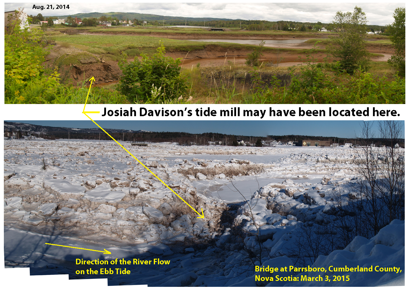
Fig.9 shows one tide mill and a possible location of a second tide mill that is no longer in existence. Both mills are on the De Wolfe Brook and they have a
permanent dam across
the De Wolfe Brook. The tidal lagoon for this brook’s estuary is a good size for a mill dam but it is not large enough for a harbour. The brook above
the estuary is too shallow and narrow for useful floating purposes.
When a river valley and its estuary were owned by one organization, permission to dam the river for a tide mill could be obtained. This was the case for Halifax
lawyers
James R. Smith and Hugh Hartshorne who had control of the Moose River on the Chignecto
Peninsula. On March 12, 1836 the Nova Scotia Legislature passed an Act
to authorize these gentlemen to erect Dams, Abutments and Piers, across the mouth of the Moose River and to erect mills in the Tideway at the mouth of the river.
Land Settlement Maps and Tidal Lagoons

Fig.6:Townships formed in 1761 for settlers from the Thirteen Colonies who were given
grants on the fertile lands vacated by the Acadians when they were forcibly removed in 1755.
|

Fig.7:Land Grants for the inhabitants of the Thirteen Colonies who were exiled from the newly formed United States because they
supported the British during the American Revolution.
|

Fig.8:The Fox River Estuary
|
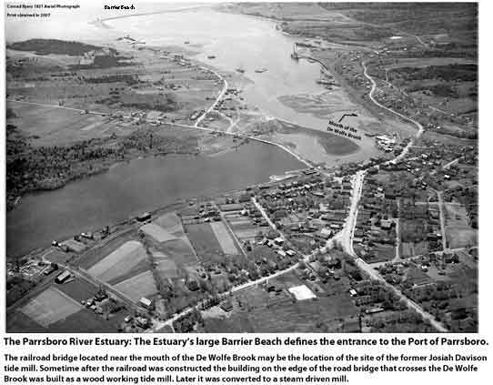
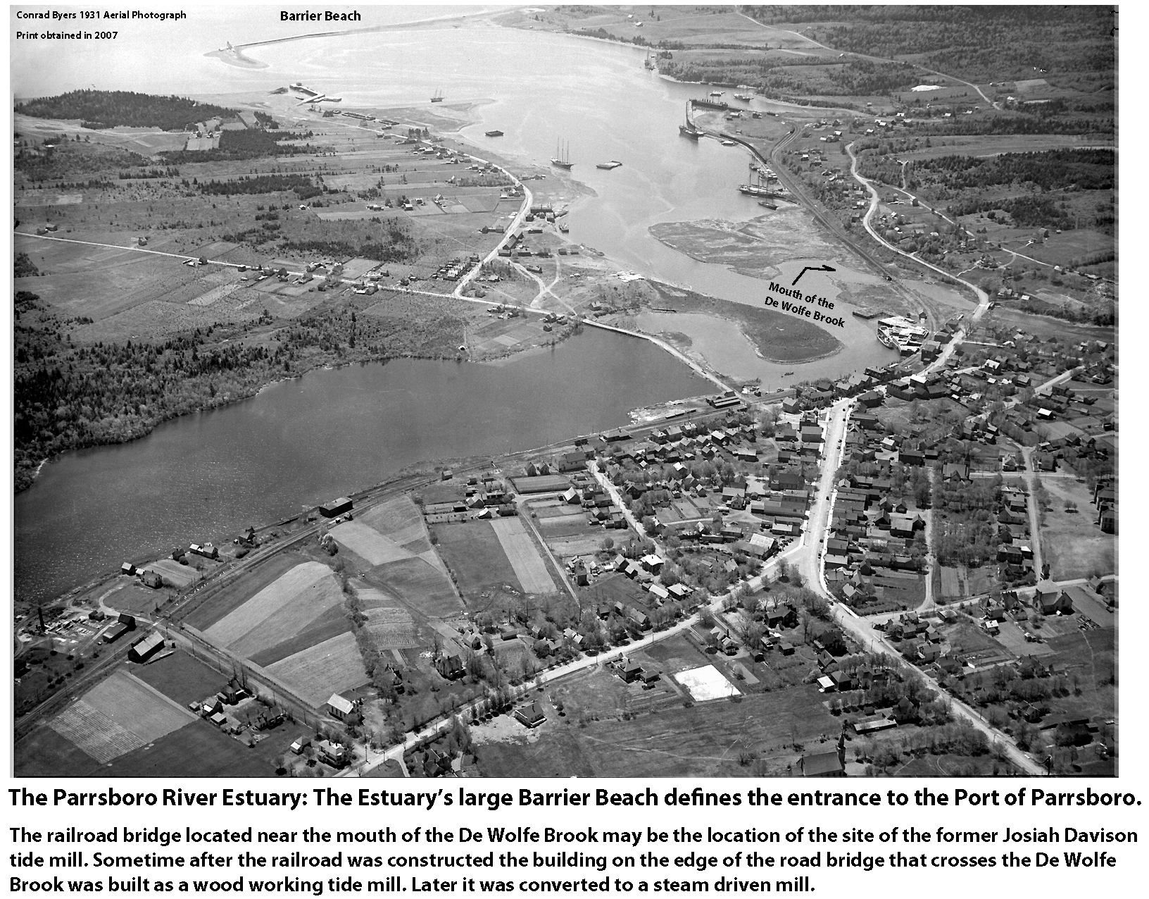
Fig.9:The Parrsboro River Estuary at High Tide.The tidal lagoon formed an important harbor that shipped lumber and coal for many decades.
|

Fig.10:The barrier beach at the entrance to the Moose River Estuary. The cribwork on the banks are the remains of wharfs used when sawmills operated on this Estuary.
|
Land Settlement Patterns and Land Ownership
At least three distinct groups have occupied the Chignecto Peninsula; these include the Aboriginals
(the indigenous peoples of Nova Scotia),
the Acadians
(French settlers) and the English speaking settlers. Mills were built by both the Acadians and the English speaking settlers.
In 1713 Peninsular Nova Scotia became a British colony by the Treaty of Utrecht and for the next forty five years, the Acadians were allowed to keep their
land. At the end of this period a process known as the Expulsion of the Acadians (Le Grand Dérangement) of 1755–1764 was initiated and at least 9000 Acadians
were forcibly exiled from Nova Scotia. By 1761,
settlers from the Thirteen Colonies, called New England Planters, had been placed on the
fertile
lands vacated by the Acadians. However, the western end of the Chignecto Peninsula received very few English speaking settlers before the signing of the
Treaty of Paris in 1783 officially ended the American Revolution, a civil war that initiated a second migration
to Nova Scotia
of people from the Thirteen Colonies. These settlers, called United Empire Loyalists, were exiled from
the newly formed United States because they
supported the British during the Revolution.
The pattern of land settlement for the New England Planters is partially shown in Fig.6. Peninsula Nova Scotia was divided into counties and townships;
the division of the townships into lots such that each family had a share of upland, meadow and salt marsh.The settlement pattern for the United Empire Loyalists who were granted land on
the western end
of the Chignecto Peninsula is shown in Fig.7
The pattern of land settlement in Nova Scotia and some locations in New Brunswick created thousands of small land grant holders. To accomplish this, the provincial
surveyors laid
out many long narrow strips of land with each strip being a possible grant; some settlers received more than one strip (See Fig.7). Furthermore, the front of each lot
was located
on the coast or a river. This was essential in the days when water was an important means of transportation. A small grant is defined as a grant of
200 to 2000 acres (80 to 800 hectares). On these forested lots a grantee and his descendants could engage in small scale lumbering activities: less than 4 people
were need to
operate a saw mill that ran from 1 to 6 months each year and produced less than 100,000
board feet per year. As well, a grantee could be an owner/operator of a grist mill.
In contrast, Monopolies, especially on Crown land in New Brunswick, allowed large scale operations: 15 to 100 employees per mill and sawing several million board feet
in a year.
These holdings, controlled by lumber barons, conisted of vast quantities of land, which means approximately 5000 acres (2023 hectares) to a
holding measured in square miles
(1 square mile = 259 hectares). Scottish timber merchant Alexander Rankin is an example of
a New Brunswick lumber baron and an example of one of the largest land holders.The Halifax lawyers James R. Smith and Hugh Hartshorne, mentioned above, who operated
a sawmill and a shipyard on the Moose River, are examples of lumber barons operating at the other end of the land spectrum.
Winter Ice, Summer Droughts, and the Eclectic Range of Skills of those who designed and built the mills.
Winter ice and summer droughts were major concerns of mill owners on the Chignecto Peninsula. Mills built upriver beyond the reach of estuary’s high tide experienced
low water levels for their mill pond during the month of August and a covering of ice and snow during the winter. Low rainfall in August and winter ice closed mills.
Droughts could be avoided by constructing a tide mill on a salt marsh provided the mill dam did not did not” interfere with the rights of others to use the streams
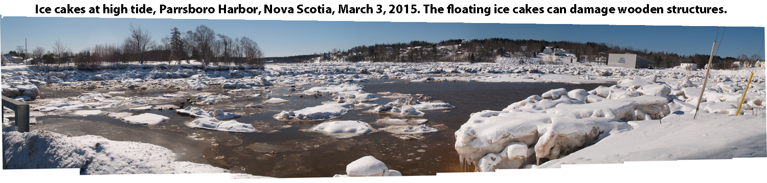
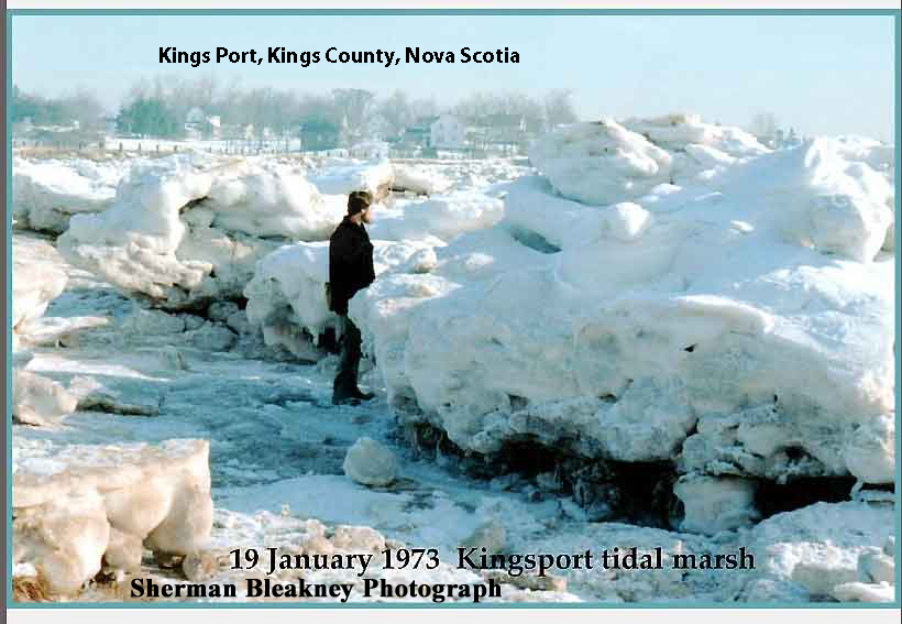
for lawful purposes.” However, as Figures 11, 12 and 13 show, the ice cakes that form on salt marshes due to heavy snow falls and high tides not only prevent a tide mill from
operating but can also damage the mill if special reinforcements are not built.
The Acadians, the New England Planters and the United Empire Loyalists brought to Nova Scotia many craftsmen who had an eclectic set of woodworking, blacksmithing and
agricultural skills, all of which were necessary for survival in the heavily forested New World of North America’s Atlantic coast. These craftsmen made it possible
for building projects to begin on the Chignecto Peninsula soon after the arrival of settlers.
The Loyalists Robert Dove, Captain of Militia, Hugh Pudsey, and Joseph Elderkin, for example, arrived on their Apple River grant shortly after it was issued in
ca.1784. They did not receive the actual paper document describing the grant boundaries and giving legal ownership to their land. In 1796 they petitioned
the governor of Nova Scotia asking that he “order their lands to be secured to them by grants”. In their petition they stated that:
“.. they became settlers of this province on lands appointed them on the Apple River in the Bay of Fundy.. in which they made large improvements by clearing lands,
building houses, barns, and a mill, to a large amount on which places they lived for upwards of eight years..”
How these skills were acquired is, at present, not known but a possible link for the Elderkin family is the existing information on a
John Elderkin, an immigrant to Lynn, Massachusetts in ca. 1637, where he owned a mill and was a master builder of churches, mills, houses, bridges and vessels
through New England. This master builder is believed to be the progenitor of the Apple River Elderkin family.
A
Medieval Studies project at the Pennsylvania State University, describes master builder John Elderkin as having a hybrid career and that such a career was not
only possible but necessary in the North American colonies. As an explanation the project states:
“The interplay between trades was relatively limited in European cultures: professional conduct was often regulated by guilds which were exclusive by their very
nature; saturation of the market in many areas meant that certain trades complained loudly when they felt their territory was being encroached upon; and rivalries
between the crafts often created a social barrier for, say, a carpenter to become a millwright or vice versa. In America on the other hand, the relative scarcity of
labor let — even demanded that — craftsmen do all the necessary jobs and then some. It is worth noting that during the roughly 150 years of the existence of the
American colonies before Independence, guilds never got a strong foothold here.”
Ice Cakes on the Salt Marshes
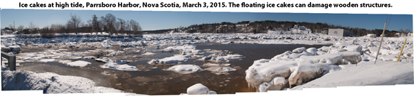
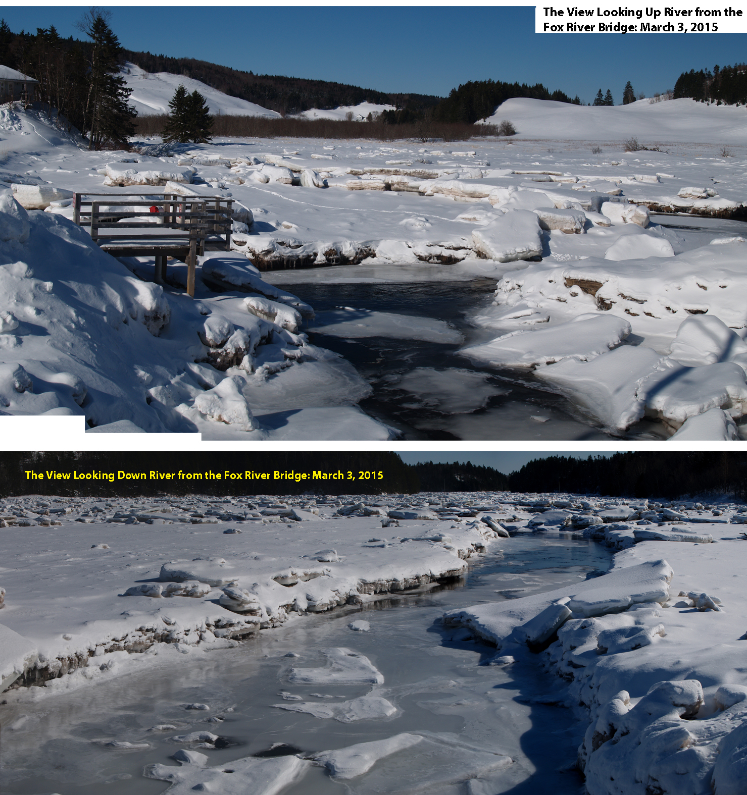
Fig.11:Ice Cakes up river at Parrsboro Harbour, Nova Scotia on March 3, 2015.This yead very little water was sufficiently ice free to allow sea birds to
land and take off. .
|

Fig.12: Ice cakes lift with an incoming tide and an exposed tide mill’s waterwheel would most likely be crushed.
|

Fig.13: Large ice cakes can form on salt marshes that experience heavy snow falls and high tides.
|
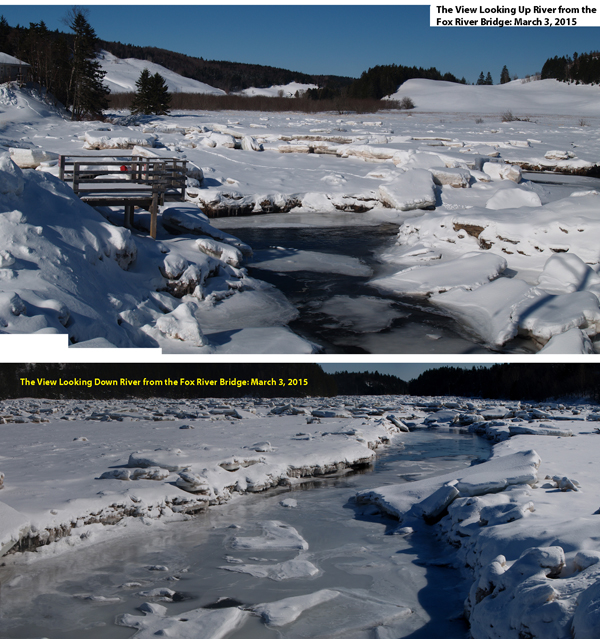
Fig.14:The ice up river is beyond the reach of the tide, is not in the form of cakes and does not move with the rise and fall of the tide.
|
Information on Individual Water Powered Mills on the Chignecto Peninsula
|
|
|
Fox River : A work in progress.
|
|
The De Wolf Brook, Parrsboro, N.S.: A work in progress.
|
DeWolf
|