Reference Material for the Spencer's Island Marine Environment:
Kerr Canning
email Kerr Canning
Introduction
The Coastal Environment at Spencer’s Island consists of tidal flats, a coastal barrier, salt marshes, and a “raised outwash terrace” formed as a result
of a complex process that took place when the ice melted at the end of the last ice age. In order to deal with the environmental and ecological
components of the Spencer’s Island coast one must become aware of the diversity, complexity, and importance of the watershed ecosystems
located on the two arms of the Upper Bay of Fundy. Such an awareness can be gained by examining the on line document “Ecosystem Overview Report
for the Minas Basin, Nova Scotia”. This report, abbreviated EOR, was prepared in 2007 for Fisheries and Oceans Canada by M.Parker, M. Westhead and A. Service.
The community of Spencer’s Island is on the north shore of the Minas Channel. The map below, found on EOR page 26, shows that Spencer’s Island
ecosystems, such its salt marsh and tidal flats, are adjacent to the Minas Basin (the major EOR study area). Differences must exist between the
Minas Channel and the Minas Basin eco-regions. I would expect, however, that these two tidal regions have enough in common for the EOR to be
useful at Spencer’s Island. An examination of the EOR table of contents will, for example, provide a list of the topics that that one must
consider in a study of any Upper Bay of Fundy ecosystem. These topics range from geology and sedimentology to the biological systems that
exist in the tidal flats, salt marshes and waters of the Minas Basin.
The EOR is a long report (179 hard copy pages and 199 PDF pages) containing a wealth of information. I suggest that you first read
“13.6 Coastal Habitats”, a four page
section starting at page 144 on the PDF version. Then consult the table of contents and read portions of EOR that are of interest.
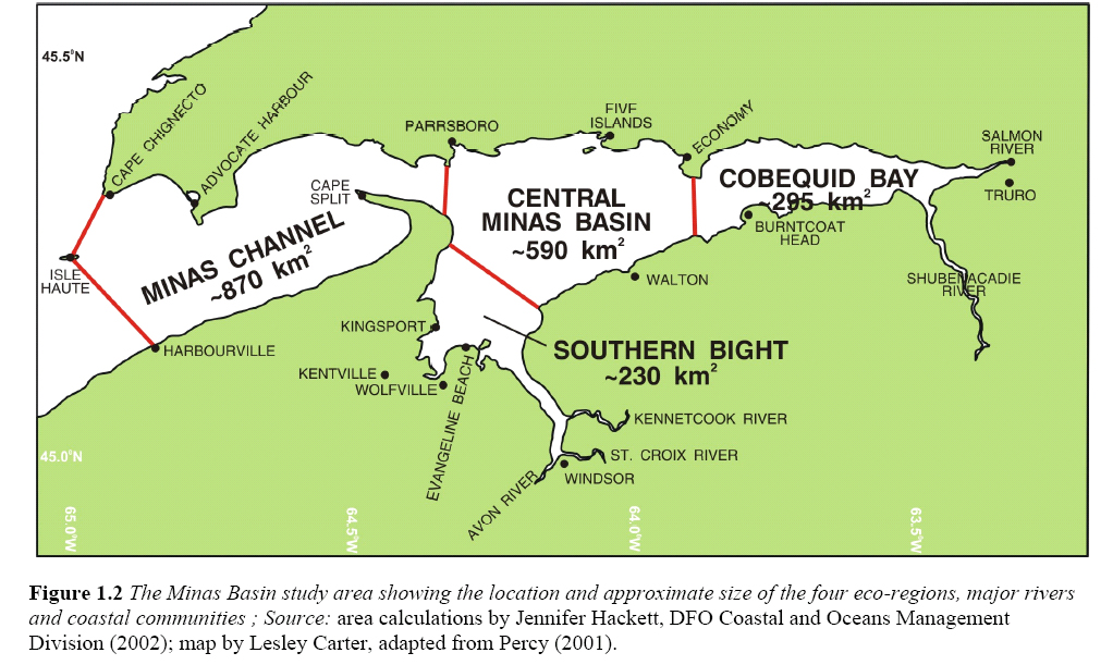
Note that the EOR defines the Minas Basin to be all of the regions shown on the above map. As well, the EOR does not use the term Upper
Bay of Fundy for the head of the Bay. The term Inner Bay of Fundy is used and the Inner Bay of Fundy “is divided into Chignecto Bay to the North and
the Minas Basin to the south.” The remainder of the Bay of Fundy is called the Outer Bay. See the EOR section “1.2 Boundaries of Study Area” on PDF page 22.
The Gulf of Maine and Links to Additional Source Material

Image courtesy of .....
A link to an interesting map that shows the Gulf of Maine Watershed can be found at the end of this web page.
Spencer’s Island, located on the Minas Channel-Minas Basin arm of the Upper Bay of Fundy, is part of a large costal environment called the Gulf of Maine.
This semi-enclosed and high tidal range sea is one of the world's most biologically productive ecosystems. Several government and non-government institutions
in both Canada and the United States are excellent source of online information on this important coastal region. Several web sites are gicen below.
- Ecology Action Centre
2705 Fern Lane
Halifax NS
B3K 4L3
Telephone: 442-5046
Protecting the Coastline: A call for a Provincial Strategy.
An article by
Jennifer Graham, Coastal Coordinator at the Ecological Action Center, Halifax, N.S.See page 30 when the link opens.
- Fundy Tidal Energy Strategic Environmental Assessment (SEA)
- Bay of Fundy Ecosystem Partnership
- Gulf of Maine Council on the Marine Environment
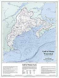
Map of the Gulf of Maine watershed.Created by Richard D. Kelly, Jr.,
Maine State Planning Office, for the Gulf of Maine Council on the Marine
Environment.