|
Possible Impacts of Highway 113 on the Proposed
Blue Mountain/Birch Cove Lakes Park and the Need for Strengthened
Protection of the Park and the Adjacent Resource
Land/Natural Corridor Area. A
submission to Environmental Assessment Branch, Nova Scotia Department of Environment and Labour, 5151 Terminal Road, Halifax, Nova Scotia B3J
2T8 e-mail: ea@gov.ns.ca Regional Planning Committee/ Regional Plan Public Hearing, Halifax Regional Municipality. c/o Clerk's Office, City Hall, 1841 Argyle Street, Halifax, NS B3J 3A5 e-mail: clerks@halifax.ca From:
Submitted
electronically and in hard copy on May 5, 2006 (Hy113DalComments.pdf) 1.
INTRODUCTION These comments are being submitted
to the Nova Scotia Department of
Environment and Labour (NSEL)
in response to a request for comments on or before May 5, 2006 on the Focus
Report for the Proposed Highway 113,
Class I Environmental Assessment
(N.S. Dept. Transportation and Public Works, March, 2006) and the associated Blue
Mountain/Birch Cove Assessment Study,
Final Report (Environmental Design
Management Limited report contracted by Halifax Regional Municipality, N.S. Dept. Transportation and Public
Works and N.S. Department of Natural Resources, March, 2006). NOTE
1 The
comments are addressed also to the Regional Planning Committee of HRM (Halifax
Regional Municipality) as they are pertinent to key aspects of protection for
the Blue Mountain/Birch Cove Lakes Park proposed in the HRM Regional Plan. This
plan was first reading in HRM Regional Council on 25 April, 2006. NOTE
2 i.
the undertaking is approved subject to specified terms and conditions
and any other approvals required by statute or regulation; ii.
an environmental-assessment report is required; or iii.
the undertaking is rejected." In
regard to the Regional Plan, a "Public Hearing to consider formal adoption of the Regional Plan, Regional
Subdivision By-law and amendments to the Municipal Planning Strategies and Land
Use By-laws of Halifax Regional Municipality necessary to implement the
Regional Plan will take place on: Tuesday, May 16, 2006 beginning at 1:00 P.M. Halifax Regional Council Chambers City Hall, 1841 Argyle
Street, Halifax." 2.
BACKGROUND The
Focus Report for the Proposed Highway 113 (hereafter referred to as the "Focus Report") addresses possibilities for increased
traffic in Halifax Regional
Municipality and a perceived need to construct a 9.9 km highway (45 m wide within a 150 m right of way)
connecting exit 3 on Highway 102 and exit 4 on Highway 103; The purpose of the proposed Highway 113
is to provide a more efficient means of travel for motorists between Highway
103 and Highway 102, that bypasses the Halifax Urban Core. It will also relieve
congestion on the Hammonds Plains Road. The proposed 4-lane divided highway
will go from Highway 103 near Exit 4 to Highway 102 near Exit 3. The
associated Blue Mountain/Birch Cove Assessment Study Final Report (hereafter
referred to as the "Assessment Study")
was conducted in connection with both the Focus Report and the HRM Regional Plan. Its focus is the delineation of a
regional park in the Blue Mountain-Birch Cove Lakes area. Such a park is formally recognized in
the Regional Plan as the "Blue Mountain Birch Cove Lakes Park" and is one of
six new parks proposed in the Regional Plan for HRM. References below to "the
Park", refer to the proposed Blue Mountain Birch Cove Lakes Park. The Park
includes approximately 1450 ha of
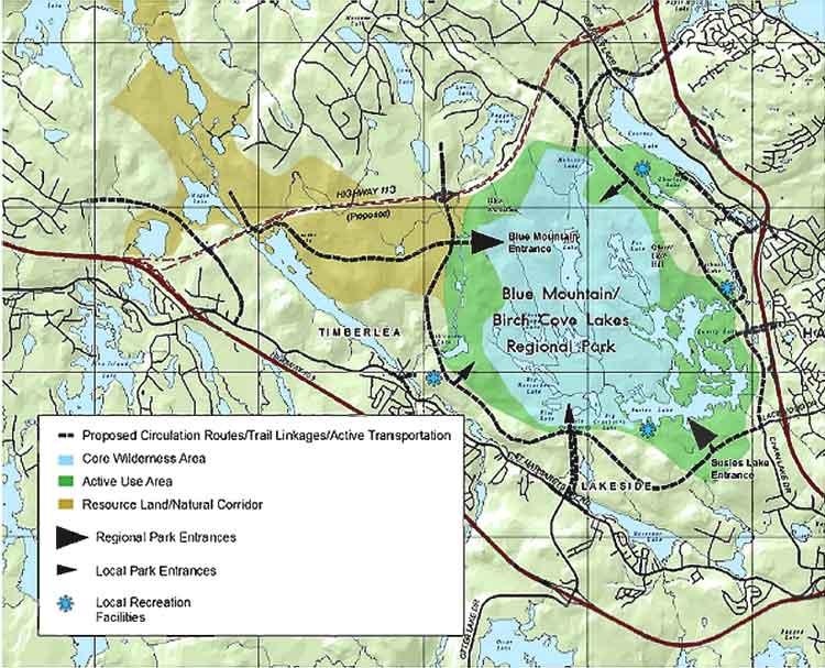
land or 1700 ha of land and water. (For convenience, Fig. 5.1 from the
Assessment Study is appended to the end of this document; it shows the location
of the Park, the adjacent Resource Lands/Natural Corridor and the proposed
highway.) The Terms of Reference for both reports required that they address in some detail the
compatibility of the proposed Highway 113
with the Park and with
broader open space and wildlife corridor functions of the area. The
highway would not be built for at least 20 years. However, ä early planning for the highway is important as this
area of HRM is developing quickly and possible routes for a new road are very
limited. The majority of the proposed highway alignment crosses private land
and generally skirts existing development. Without corridor preservation the
majority of land required for the highway could be privately developed. The
expected result would be either the elimination of any options for the highway
alignment or a highway project that has higher construction costs, and causes
greater impacts on existing development and the environment. Some property has
been purchased in order to preserve a corridor for the highway where imminent
development would have prevented preservation of the landä Corridor
preservation work for the proposed Highway 113 began in 1998. The
overall conclusion reached in these reports in regard to ecological impacts
of Highway 113 appears to be that
while it is a potential threat to
natural values in the area, the direct impact is minimal and it can serve as "an effective barrier to future
encroachments by development"; further, "The Department [of Transportation and
Public Works] recognizes the potential requirement for wildlife corridors and
trail connections." 3.
COMMENTS The Assessment Study provides an excellent characterization of the many natural
values of the proposed Blue Mountain/Birch Cove Park area and their importance
for HRM. NOTE 3 We support the concept of an "Ideal Regional Park", which would
include a large Core Wilderness
area and a peripheral Active Use
area, also an adjacent Resource Land/Natural Corridor. The last mentioned is
not formally in the Park but it is integral to its ecological integrity and
important for movement of wildlife between the Chebucto Peninsula and the
greater mainland.
Such
a park would be a magnificent and perhaps unique resource including, as it
would, a protected, ecologically diverse wilderness area and providing
"Keji-like opportunities" within the confines of a major city. It will become highly valued by residents and visitors much as
historic properties and our seashore are today. In addition to its inherent
natural values and importance for protection of our water resources,
it could become a significant contributor to our economy through ecotourism. Perhaps more significantly for the
economy, it would give HRM "a lot
to crow about" as a superb place
to live. In the 21st century, access to "the outdoors" is an
important consideration for
many of the industries and
businesses and associated skilled workers and professionals we want to attract
and keep in this area. It is also highly appropriate for a capital region to
illustrate a firm commitment to protection of the environment and biodiversity
and a willingness to make the
kinds of sacrifices that are more commonly asked of rural residents of Nova
Scotia. It is highly prudent to make key decisions at this time given the
strong development pressure in the area and the increased costs from rising land prices that would be
associated with delaying decisions; further we will quickly lose many options as highways and
residential and commercial developments impinge on areas that are now
wilderness or quasi-wilderness. Indeed we are very fortunate in being able to
make the choices presently before us. There
are, however, several concerns in these regards. One arises
primarily from significant omissions in the reports related to potential
impacts on the ecology of the area,
and two have more to do with the legalities and practical difficulties
of protecting important
ecological features of the area.
Consideration of the likelihood of dramatically altered traffic demands and
patterns associated with rapidly rising fuel costs is an additional omission
that is not cited here but we understand is the subject of one or more other
submissions. Also, these comments
focus on a few issues, not all
possible issues, related to the ecology of the area. Concern
No. 1: The reports do not adequately address potential
negative impacts of the highway on ecological functioning of the area, nor do
they adequately address highway design features to mitigate such effects. Except
for impacts on wildlife corridor functions, the Focus Report and Assessment
Study do not discuss in any detail, possible direct negative impacts of the
highway beyond the right-of-way boundaries on either the Park itself, or on the
adjacent Resource Lands/Natural Corridor area. There is substantive scientific literature on this topic.
The following is an example: The Ecological Road-Effect Zone of a
Massachusetts (U.S.A.) Suburban Highway Richard T. T. Forman* and Robert D.
Deblinger, Conservation Biology 14: 1523-1739 (2000) Abstract: Ecological flows and biological diversity
trace broad patterns across the landscape, whereas transportation planning for
human mobility traditionally focuses on a narrow strip close to a road or
highway. To help close this gap we examined the "road-effect zone"
over which significant ecological effects extend outward from a road. Nine
ecological factors—involving wetlands, streams, road salt, exotic plants,
moose, deer, amphibians, forest birds, and grassland birds—were measured
or estimated near 25 km of a busy four-lane highway west of Boston,
Massachusetts. The effects of all factors extended >100 m from the road, and moose corridors,
road avoidance by grassland birds, and perhaps road salt in a shallow reservoir
extended outwards >1
km. Most factors had effects at 2–5 specific locations, whereas traffic
noise apparently exerted effects along most of the road length. Creating a map
of these effects indicates that the road-effect zone averages approximately 600
m in width and is asymmetric, with convoluted boundaries and a few long
fingers. We conclude that busy roads and nature reserves should be well separated,
and that future transportation systems across landscapes can provide for
ecological flows and biological diversity in addition to safe and efficient
human mobility. The
Assessment Study correctly identified
the importance of preserving wildlife corridor functions in the area,
including areas to the west
of the proposed park as (i)
a corridor for movement of wildlife between the Chebucto
Peninsula and Mainland Nova Scotia; The Blue Mountain/Birch
Cove Lakes area occupies a strategic location as the connecting green
space/wilderness area at the "pinch point" between approximately 22,000
hectares of undeveloped land on the Chebucto Peninsula and the greater mainland
of central Nova Scotia. The pinch point of the Chebucto Peninsula extends
approximately 18 kms between the Head of St. Margaret's Bay east to the Bedford
Basin, the widest section of the Blue Mountain/Birch Cove Lakes Study Area is
approximately 10 kms across this same corridor leaving only 8 kms of land
connecting the Chebucto Peninsula to the greater mainland. (Assessment Study,
p.24). (ii)
a corridor and/or habitat for migration of species into the Park, necessary for
the long term maintenance of the current level of biodiversity: It is important to note that while it may be
determined in the future that connectivity is not be required at a provincial
level of concern between the two large Crown parcels, the proposed Blue
Mountain/Birch Cove Lakes Park should still be connected to adjacent resource
lands. This connectivity is necessary to maintain the diversity and species
richness within the park boundary. As human use of the park intensifies the
pressure on individual species will increase, and many species will slowly die
out if there is not a ready population that can easily re-populate the park on
a regular basis. In addition, without connectivity the genetic pool within the
park may become limited over time for species without a sufficiently large
population. Connectivity also helps the park be more resilient to disturbances
such as a fire, hurricane or other natural disaster. Maintenance of species
diversity within the proposed park area over the long term will likely require
connectivity to at least one resource area and preferably two. (Assessment
Study, p. 46) Fragmentation
of contiguous wild (or largely unmanaged)
landscapes is the major cause of species loss globally and locally over
the last century. This is only
partially due to loss of habitat per se.
Today, professional ecologists talk about "the flux of nature" rather than
a " balance of nature", recognizing that populations of different species are
not static; the norm is for populations to fluctuate over time and even to go
locally extinct due to natural cycles and natural or manmade catastrophic
events such as fire and disease.
Thus, immigration of
individuals into an area becomes critical for the long-term maintenance of a species in that area (and the same area also acts at times as a source of
immigrants for other areas).
Fragmentation of natural landscapes leads to loss of species in an
otherwise suitable area by eliminating the possibility for immigration or by reducing the rate of immigration below that necessary to
maintain a population over longer periods of time or at critical times. The degree of landscape
connectivity that is required to maintain a species in a particular area
depends on the species and local factors; in general, the larger the local area, the less sensitive it is to the
degree of connectivity with other areas, but of course a larger area would be
required to maintain moose than for example, a ground beetle. This
short discussion is offered to emphasize two points: (i) populations of all species, including, for example, plants and insects, and not just those of
the larger or more noticeable animals (deer, moose, frogs etc,) are sensitive
to reductions in the degree of connectivity of landscapes; (ii) regardless
of special passage-ways that might
be built into the design of the highway and that might be adequate for some, more
mobile species, there will be
reductions in overall connectivity, i.e. it is inevitable that a highway will
lead to some (negative) effects on connectivity and biodiversity within the
proposed park. The
connectivity issue is very significant in relation to the Park. A high degree
of connectivity is critical because of
the Park's relatively small size; maintenance of ecological integrity
over the longer term – especially if there are fires - will be highly dependent on
connectivity and immigration. That there will be fires, started by natural
processes or by humans, seems to
be a fairly safe prediction. (In fact,
much of the vegetation in quasi-wilderness areas of HRM consists of
early successional species that are either stimulated by fire (e.g, jack pine), or stimulated by release of
competition by fires (e.g., white
birch, large tooth aspen). In
regard to migration of species between the greater mainland and the Chebucto
Peninsula, connectivity is probably not highly critical for maintenance of
smaller and more numerous species in the Chebucto Peninsula, but it could be
for larger animals, e.g., moose, brown bear, deer, as noted in the Assessment
Study. NOTE 4 Of particular
concern is the fact that highway 113, in the absence of specific design
features, would eliminate two of the three existing "key opportunities" that
facilitate movement of such
wildlife between the Chebucto Peninsula wilderness areas and the Bowater Mersey
lands north of Hammonds Plains Road (Assessment Study p. 45; Appendix A: Figure
20). These
effects and how they will be dealt with are not addressed in any detail in the
Focus Report or in the Assessment Study; rather it is recommended simply that
"highway design that facilitates the movement of a wide variety of plants and
animals should be consideredä" and
TPW comments that In consultation with DNR, the provision of passage for
a variety of species will be considered in the design of the structure crossing
the Maple Lake/Frasers Lake watercourse; in addition, four water crossings will
be required over Fishers Brook and Stillwater Run; two of these are fish
habitat; avoidance of fish habitat damage and provision of fish passage must be
provided for these crossings; in the design of these crossings consideration will
be given to providing sufficient width and span height to allow the passage of
all but the largest wildlife species, which would provide connectivity in areas
with less human presence than the Maple Lake/Frasers Lake crossing may have. That
on its own might be reassuring if the design of wildlife corridors through
highways was a well developed science. It isn't. There is a large literature in this area. An authoritative
recent text on Ecosystem Management notes possible pitfalls of designed
corridors and comments: At present we do not understand corridors well enough
to evaluate these possible pitfall. In the years to come, after more movement
corridors have been designed, implemented, and monitored for success, we will
better understand their potential advantages and disadvantages. In the meantime
we need to try and reconnect landscapes that were historically connected and
that have become fragmented though human use. (GK Meffe et al., Ecosystem Management: Adaptive,
Community-based Conservation Island Press, 2002) Further
there have been many practical difficulties with maintaining wildlife corridors
through highways, and the more
elaborate, possibly more effective,
corridors are very expensive. These issues have not been addressed in
relation to the proposed highway. Concern
No, 2 Insufficient
consideration is given to the need to protect the Resource lands/Natural
Corridor area to the west of the
proposed park and highway, and
for immediate protection of the entire area from development. Even
if the highway were constructed with effective wildlife passageways, or even if
it were not constructed at all, the wildlife corridor lands and significant
wetlands and other water resources to the west of the proposed park and highway
– as well as the Core Wilderness Area and the peripheral Active Use Area - are potentially subject to fragmentation and physical
disruption through development of
existing private holdings.
Further, statements in the focus report give some concern that tradeoffs
of crown land in this western area might be made with local developers in
exchange for private lands currently held within the planned highway right of
way. In
the Assessment Study it is noted: Connecting the park to resource lands could require
management control and/or acquisition of critical parcels in the area between
Timberlea, Kingswood, and Hammonds Plains, as indicated in Figure 20 of Appendix A entitled Connectivity. However,
there is not much further discussion of this issue, which is clearly critical
for connectivity. Understandably
the Focus Report, coming from the Department of Transportation and Public
Works, focuses on securing rights
of way for the Highway. The
discussion reveals the sorts of tradeoffs that have occurred before: Over time, some of the crown land has
been traded off to developers for other properties or assets resulting in some
erosion of the crown land holdings.
As well, development
pressure in the area is raising the cost of purchasing private land that might
be added to the crown land for protection [ of the proposed Park] and actual developments are gradually
encroaching on the proposed protected [Park] area; similarly, these pressure
are raising the costs of private land that would need to be purchased to build
the connector highway or, through development, could directly encroach on the
proposed highway. It is clear
from various statements in the reports that there is good reason to be
concerned about development pressures and that possible land swaps in favour of
the highway would detract from the western corridor area, e.g., on p. 33 of the Assessment
Study it is noted: ÄMapping of developed and developable private land
indicates the rapid rate of development and the likelihood of development on
private lands which would preclude construction of Highway 113, if the corridor
were not established well before planned highway construction; Ä Developers have modified their plans based on the
publication of the plans for Highway 113, confirming the need to establish the
corridor and identifying a need to resolve the issue, so that developers can
proceed. On page 50
it is noted: The Crown
and private lands lying to the south and west of the generalized park area form
an important natural corridor, providing connectivity to the more extensive
Crown and Bowater lands to the south and westä A critical link in this corridor
is at Maple Lake/Frasers Lake where the proposed Highway 113 corridor crosses
the lake system. The highway will be located on one of the few remaining
"necks" of land available for species movement. The Piercey Investors
subdivision development on their lands to the west of the lakes may present a
significant complication for this initiative. Also,
large sections in the western area are rated at the two top levels in the
suitability scale for unserviced
residences (Fig 12 of the Appendix to the Assessment Study), which would add to pressure to trade off these area
off for private lands needed for the Highway right-of-way. Clearly the same development pressures that threaten the right-of-way
for Highway 113, also threaten the maintenance of or procurement of additional
lands to ensure the integrity of
the resource lands/natural corridor west of the proposed park and
highway 113 as well as the Core Wilderness area and the peripheral Active Use area. The difference is that
procurement of land to secure a right-of-way for Highway 113 began in 1998 and
is the focus of TPW concerns
(understandably), while equivalent
consideration and priority has not
been given to ensure the integrity of
the western Resource lands/Natural Corridor area or even of the Core Wilderness area and the peripheral Active Use area of the
Park proper. The highway is promoted as "an effective barrier to future encroachment
[of the Park] by development". However, the protection afforded by the highway is not a physical barrier but rather a
legal barrier associated with procurement of the right of way 20 or years
before a highway might even be considered. There seems no logical reason why,
in the same context, the same kind of insurance should not be applied to
securing the integrity of the western Resource Land/Natural Corridor area as
well as that of the Core Wilderness area and the peripheral Active Use area of the Park proper. Future generations will thank us for leaving all options fully open at
a time when we still have the choice to do so, not just those related to the
highway. Concern
No. 3 There is some
ambiguity in the proposal to maintain a large core wilderness area in the Park,
but not to give it wilderness area status under the Wilderness Areas Protection Act. Giving
such status to the core wilderness area would be the best way to protect it,
while still allowing the core area recreational activities discussed in the
Assessment Study. This designation
would be very appropriate in the context of this area being in an urban capital
city. It would be an invaluable educational tool for residents of HRM, an
additional "crow factor" for HRM, and the best practical protection we could
give to the most valued features of the Park. 4.
CONCLUSION The
Assessment Study is excellent in many regards, but is seriously deficient in
regard to possible direct negative impacts of the proposed highway beyond it's
the right-of-way and in regard to the limitations and challenges of mitigating
effects of the highway on corridor functions. The need to protect the western
Resource Land/Natural Corridor area is cited, but is not emphasized and is not
given due consideration in the Focus Report. The Assessment Study indicates
that the proposed boundaries are not fixed, but are adaptable which, given the
development pressure in the area and the high priority given to procurement of
right of way for the highway, raises concerns about possible opportunistic and
irreversible development in key
areas and about possible tradeoffs of land that would compromise the integrity
of the Park and the western Resource Land/Natural Corridor area. Thus we
suggest: ∑
If the highway option is not rejected, a full
environmental review should be required.
At the minimum, the necessity to secure the western Resource
Land/Natural Corridor as well as the Core Wilderness area and the peripheral Active Use area should
be given as much emphasis as that given to procurement of lands for the highway
right-of-way. ∑
Regardless of whether the highway option is rejected or
maintained, the integrity of the western resource Land/Natural Corridor area,
as well as that of the Park proper, need to be secured; an immediate, unequivocal
moratorium should be placed on any further development in the entire area. ∑
The benefits of giving the Core Wilderness area
protection under Wilderness Areas Protection Act should be seriously considered. NOTES 1. The pertinent announcements and documents were accessed
at a Nova Scotia Department of Environment and Labour webpage: Highway 113
Project at: www.gov.ns.ca/enla/ea/highway113.asp The relevant documents are available as downloadable PDF
documents, including: Focus Report (1.1
mb) www.gov.ns.ca/enla/ea/highway113/Hwy113_FocusReportPublicNotice.pdf The text of the Assessment
Study is contained in Appendix B1 (8.3 mb) and Appendix B2
(8.1 mb): www.gov.ns.ca/enla/ea/highway113/Hwy113_app_b1.pdf
www.gov.ns.ca/enla/ea/highway113/Hwy113_app_b2.pdf Terms of Reference, detailed
GIS-based maps, the traffic
projection study and other relevant documents are also accessible via the
Highway 113 Project webpage. For convenience, Assessment Study
Fig. 5.1 showing the location and boundaries of the proposed Blue
Mountain/Birch Cove Lakes Park and the adjacent Resource Lands/Natural Corridor
area and the proposed highway is appended to the end of this document. 2. See HRM Regional Planning for HRM at www.halifax.ca/regionalplanning/
The full Plan is available at www.halifax.ca/regionalplanning/FinalRegPlan.html
Map 13 listed on that page shows the location and boundaries of the
proposed Blue Mountain Birch Coves Lake Park and the adjacent Resource
Lands/Natural Corridor. 3. Public
Interest Group Values for the Blue Mountain/Birch Cove lakes area cited in the
Assessment Study include ÄLast piece of
publicly owned wilderness in this part of HRM Ä Largest area without
roads near the Halifax urban concentration Ä Known populations of
endangered mainland moose (Chebucto population) Ä Contains 22 lakes
and ponds many of which are entirely surrounded by public land Ä Contains headwaters
of the Kearney Lake, Papermill Lake, and Nine Mile River watersheds Ä Diverse mosaic of
ecosystem types, including numerous forest types (e.g., white pine, red spruce, red
oak, yellow birch, white birch, poplar, red maple, black spruce, mountain ash),
wetlands, barrens, aquatic areas, rivers, rapids, cliffs Ä Presence of southern
coastal plain flora species adjacent to sub-arctic alpine plants. Ä Several stands of
old-growth Acadian forests, including exceptional stands of old red oak, old red
spruce, and old white pine (with understories of similar species compositions). Ä Presence of a
naturally rare stand of jack pine (fire dependent ecosystem) Ä Presence of at least
two rare granite barren ecosystems dominated by tolerant red oak species (red oaks
usually occur in relatively nutrient rich areas) Ä Numerous granite
barren ecosystems, and associated rare arctic-alpine plants (e.g., Greenland
sandwort (Arenaria groenlandica)) Ä Numerous wetlands with
examples of bogs, fens, swamps, and shallow water areas Ä Significant
wetlands, including the "promised lands," Stillwater Run, and the lakeshore fens of the
Birch Cove Lakes canoe loop Ä Highest point of
land in Metro Halifax ("Blue Mountain Hill")14
with associated windblown treeless
area and sub-arctic alpine plants Ä Abundance of bird
species, with 146 different species recorded by the Nova Scotia Bird Society
(e.g., osprey, loon, bald eagle, blue heron, mourning dove, American kestrel,
Swainson's thrush, pileated woodpecker, great-horned owl, cedar waxwing, etc.)
owing to geographic location and habitat diversity. Many of these are breeders.
Some are recognized as rare species. 4. Some
argument is made that the Mainland Moose numbers in this region are so low (approximately 30 centered on the Chebucto Peninsula, and
20 in the Ship Harbour area) that we can really not make a strong case for
extra-ordinary measures to protect them;
the survival of mainland moose is dependent on maintenance of the larger
concentrations elsewhere. That may be true in a strict sense. However, they do
or could have strong symbolic value;
as a large, rather elusive
species, real efforts made to protect the Halifax County moose will
protect many other species and habitats. The Florida panther is an appropriate
analogy; there are only approximately 50 of these animals left in the whole
state of Florida, but extra-ordinary efforts, highly supported by the
public, are being made to conserve
them. This could hardly be justified
economically or even by wildlife biologists were it not that the efforts to conserve the Florida
panther - including protection of key corridor areas – also protect key
habitats for many other species. In Nova Scotia the Mainland Moose could be our
Florida Panther! Additionally, by giving proper protection to moose in the
capital area, there will less resentment of protection measures in rural areas.
The next
page is Figure. 5.1 (Proposed Blue Mountain/Birch Cove lakes Park) from the
Assessment Study (p. 47). |